Maps of North Region

Sud-America in zwei Blattern.
1 : 14000000 Stulpnagel, F.v.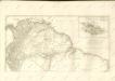
Amerique du Sud (Partie Septentrionale).
1 : 13575000 Migeon, J.
Süd-America
Hand-Atlas über alle Theile der Erde nach dem neuesten Zustande und über das Weltgebäude Stieler, Adolf bei Justus Perthes
Sudamerika nordliches Blatt.
1 : 20000000 Andree, Richard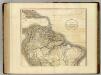
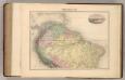
South America north.
1 : 10500000 Cary, John, ca. 1754-1835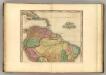
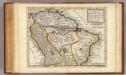
South America (northern half).
1 : 10200000 Tanner, Henry S.
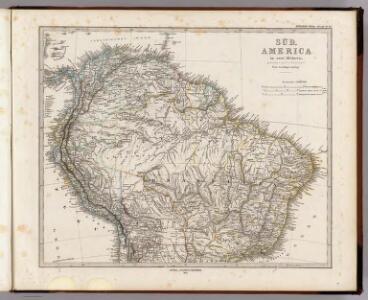
Süd-America in zwei Blättern
Hand-Atlas über alle Theile der Erde nach dem neuesten Zustande und über das Weltgebäude Stieler, Adolf bei Justus Perthes
Süd-America
Handatlas über alle Theile der Erde und über das Weltgebäude Stieler, Adolf Justus Perthes
South America and West Indies.
1 : 10500000 Tanner, Henry S.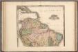
South America and West Indies.
1 : 10500000 Tanner, Henry S.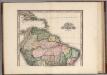
South America and West Indies. 1818
1 : 10500000 Tanner, Henry S.
Süd-America in zwei Blättern
Hand-Atlas über alle Theile der Erde und über das Weltgebäude Stieler, Adolf Justus Perthes
Der Nördliche Theil von Süd-America enthaltend Columbia, Guyana, Peru, Brasielien und Bolivia
Stieler's Hand-Atlas Stieler, Adolf bei Justus Perthes
Der nördliche Theil von Süd-America enthaltend Columbia, Guyana, Peru, Brasilien und Bolivia
1 : 7600000 in Mercators Projection nach den besten Hülfsmitteln bearb. und gezeichnet v. Pr. L[t]. v. Stülpnagel Hase sc. Gotha : Perthes
General-Charte von Süd America
Brazílie Spix, Johann Baptist von Martius, Carl Friedrich Philipp von
Map of Terra Firma, Peru, Amazone-Land, Brasil &c.
1 : 22000000 Moll, Herman, d. 1732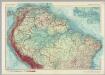
Northern South America. Pergamon World Atlas.
1 : 10000000 Polish Army Topography Service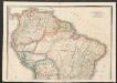
South America [North]
A new general atlas of modern geography, consisting of a complete collection of maps of the four quarters of the globe Wyld, James James Wyld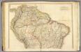
(Colombia Prima, S. America) N sheet.
1 : 7300000 Delarochette, Louis Stanislas d'Arcy; Faden, William, 1750?-1836
Carte de la Terre Ferme, du Perou, du Bresil et du Pays des Amazones
1 : 9000000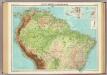
South America - northern section.
1 : 10000000 John Bartholomew and Son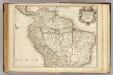
Terre Ferme, Perou, Bresil, Amazones.
1 : 9000000 L'Isle, Guillaume de, 1675-1726
Carte de la terre ferme du Perou, du Bresil et du Pays des Amazones
1 : 9000000 dressée sur les descriptions de Herrera de Laet, et des PP. Acuña, et M. Rodriguez et sur plusieurs relations et observations posterieures par Guillaume del'Isle A Amsteldam : chez Jean Covens et Corneille Mortier, geographes
Tabula Americæ specialis geographica regni Peru, Brasiliæ, Terræ Firmæ & reg: Amazonum
1 Karte : Kupferdruck ; 47 x 54 cm L'Isle; Herrera; Rodriguez; Acuña; Laet nunc recusa per Homannianos heredes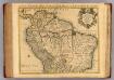
Terre Ferme, Perou, Bresil, et du pays des Amazones.
1 : 9000000 L'Isle, Guillaume de, 1675-1726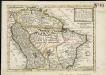
A map of Terra Firma Peru, Amazone-land, Brasil & the north p[art] of La Plata
1 : 18000000 Moll, Herman Bowles, Thomas
TABULA AMERICAE SPECIALIS GEOGRAPHICA REGNI PERU, BRASILIAE, TERRAE FIRMAE, & reg. AMAZONUM
Amazonka-oblast Delisle, Guillaume Acuna, Cristóbal de per Homan[n]ianos Heredes
TABULA AMERICAE SPECIALIS GEOGRAPHICA REGNI PERU, BRASILIAE, TERRAE FIRMAE, & reg. AMAZONUM
Amazonka-oblast Delisle, Guillaume Acuna, Cristóbal de per Homan[n]ianos Heredes