Maps of Arabian Peninsula

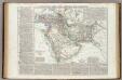
Nordost-Afrika Und Arabien.
1 : 12500000 Petermann, A.
[Mittel- und Nord-Africa, Oestl. Theil und Arabien]
Hand-Atlas über alle Theile der Erde und über das Weltgebäude Stieler, Adolf Justus Perthes
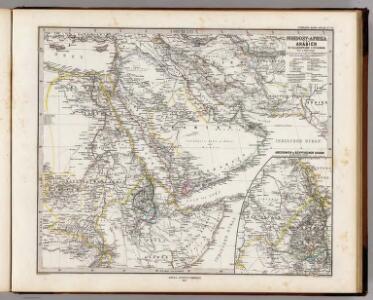
Nordost-Afrika und Arabien
Handatlas über alle Theile der Erde und über das Weltgebäude Stieler, Adolf Justus Perthes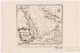
Carte de la coste d'Arabie, Mer Rouge et Golfe de Perse : tirée de la Carte de l'Océan Oriental publiée en 1740 par Ordre de Mgr le Comte de Maurepas augmentée sur des remarques particulières et dressée sur des observations astronomiques = Kaart van de Kust van Arabië, de Roode-Zee en de Gulf van Persië Gemaakt na de Fransse-Kaart van den Ooster-Ocean uitgegeven A. 1740 op Bevel van den Hre Grave de Maurepas Vermeederd op byzondere Aanmerkingen, en geschikt volgens Sterrekundige-Waarnemi
1 : 14000000 Schley, Jacobus van der, 1715-1779 Pierre de Hondt
Carte des trois Arabies : tirée en partie de l'Arabe de Nubie, en partie de diuers autres autheurs
1 : 7500000 Sanson, Nicolas, 1600-1667 Chez Pierre Mariette
Tabula Asiae VI. [Karte], in: Claud. Ptolemaeus. Geographia lat. cum mappis [...], S. 311.
1 Karte aus Atlas Münster, Sebastian [und Ptolemaeus, Claudius]
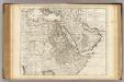
[Mittel- und Nord-Africa und Arabien, Oestliches Blatt]
Hand-Atlas über alle Theile der Erde nach dem neuesten Zustande und über das Weltgebäude Stieler, Adolf bei Justus Perthes
Sexta Asie Tabula [Karte], in: Claudii Ptolemei viri Alexandrini mathematice discipline philosophi doctissimi geographie opus [...], S. 208.
1 Karte aus Atlas Waldseemüller, Martin [und Ptolemaeus, Claudius] Übelin, Georg

Mittel- und Nord-Africa und Arabien. Östliches Blatt
Stieler's Hand-Atlas Stieler, Adolf bei Justus Perthes
Tabula Asiae VI. [Karte], in: Geographia universalis vetus et nova complectens Claudii Ptolemaei Alexandrini enarrationis libros VIII, S. 281.
1 Karte aus Atlas Münster, Sebastian [und Ptolemaeus, Claudius]
Sexta Asie Tabula [Karte], in: [Clavdii Ptholomei Cosmographi ...], S. 317.
1 Karte aus Atlas Nicolaus Germanus [und Ptolemaeus, Claudius]
Turkey, Saudi Arabia, Afghanistan, and Iran.
1 : 14630000 Johnson, A.J.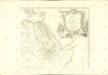
Egypte, Nubie, Abissinie &c.
1 : 9200000 L'Isle, Guillaume de, 1675-1726
Alexandri Magni Macedonis expeditio
Asie jihozápadní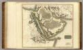
Arabia, Egypt, Abyssinia, Red Sea.
1 : 6500000 Thomson, John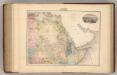
Afrique (Partie Nord-Est).
1 : 14400000 Migeon, J.
Vorder-Asien und Nil-Land
Schul-Atlas über alle Theile der Erde nach dem neuesten Zustande, und über das Weltgebäude Stieler, Adolf Justus Perthes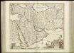
[76][76] Nova Persiae Armeniae Natoliae et Arabiae descriptio, uit: Atlas sive Descriptio terrarum orbis
Annotatie: Gedigitaliseerde versie. Amsterdam. Heiloo : Picturae (vervaardiger), 2015. tiff-bestand. Gedigitaliseerd: 07-01-2015; Origineel: Universiteitsbibliotheek Vrije Universiteit (XL.05127.-) ; Netherlands; Titelpagina ontbreekt Wit, Frederik de Amsterdam : Frederick de Wit
Carte de l'Egypte de la Nubie de l'Abissinie
1 : 9100000 Afrika severní Delisle, Guillaume Desrosiers, F. Guillame del'Isle
Africa orientale e la colonia italiana d'Assab
1 : 1455000 Eritrea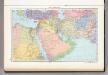
154. Near and Middle East, Political. The World Atlas.
1 : 12500000 USSR (Union of Soviet Socialist Republics).
Persia Arabia.
1 : 12000000 Colton, G.W.
L'Asie Antérieure
1 : 9000000
Vorder-Asien und das Land des Nil
E. von Sydow's Schul-Atlas in sechs und dreissig Karten Sydow, Emil von bei Justus Perthes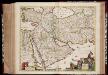
Nova Persiae Armeniae Natoliae et Arabiae descriptio / per F. de Wit
1 : 9250000 Annotatie: Origineel is Blad 180 in atlas factice; Annotatie geografische gegevens: Schaalstok op kaart: 75 Milliaria Germanica communia (=6 cm), en Gemeene Duytsche Mylen van 15 in een Graedt (=6 cm) Frederick de Wit 1630-1706 t'Amsterdam : by Frederick de Wit inde Kalverstraet inde Witte Pascaert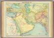
South-western Asia.
1 : 10000000 John Bartholomew and Son
Western Asia