Maps of Poland

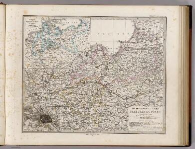
Die Preussischen Provinzen Preussen Und Posen.
1 : 1850000 Vogel, C.
Die Preussischen Provinzen Preussen und Posen
Handatlas über alle Theile der Erde und über das Weltgebäude Stieler, Adolf Justus Perthes
[Die Preussischen Provinzen, Preussen und Posen]
Hand-Atlas über alle Theile der Erde und über das Weltgebäude Stieler, Adolf Justus Perthes
Ostdeutschland
Volksschul-Atlas über alle Teile der Erde Lange, Henry Druck und Verlag von Georg Westermann
Preussen, Polen.
1 : 3000000 Haller von Hallerstein, Friedrich; Reichard, C. G.
Charte von den Königreichen Preussen und Polen, dem Grosherzogthum Posen nebst dem Gebiete der freien Stadt Krakau. Nach dem am 3. May 1815 zu Wien zwischen Russland, Preussen und Oesterreich abgeschlossenen Tractate
Kongresspolen, Provinz Posen
German Empire E, Poland.
1 : 1584000 Stanford, Edward
Prussian Dominions.
1 : 1440000 Pinkerton, John, 1758-1826
[Nordöstl. Deutschland und Polen]
[Allgemeiner Atlas über alle Theile der Erde in 29 Blättern] Ziegler, Jakob Melchior Top. Anstalt v. J. Wurster u. Comp.
Prussian Dominions.
1 : 1450000 Thomson, John
[Das Deutsches Reich, Blatt 2]
Adolf Stieler's Handatlas über alle Theile der Erde und über das Weltgebäude Stieler, Adolf Justus Perthes
Prussia.
1 : 3400000 Finley, Anthony
Generale-Charte der Preussischen Monarchie in zwey Blättern
1 : 1030000 Prusko Streit, Friedrich Wilhelm Gilly Geograph. Institut
Charte des nordöstlichen Deutschlands nebst Preussen u. Polen
Preußen, Kongresspolen
Germany, eastern border regions surface configuration
Relief shown by gradient tints. Includes most of western Poland. Includes location map. United States. Office of Strategic Services. Research and Analysis Branch. [Washington, D.C.] : R & A, OSS
Prussia and Saxony.
1 : 3000000 Colton, G.W.
Prussia.
1 : 3300000 Tanner, Henry S.
Charte vom Königreiche Preussen dem Herzogthume Warschau und dem neuen Danziger Gebiethe
1 : 1510000 Gdaňsk-oblast (Polsko) Soltzmann, D. F. Geographischen Instituts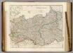
Prussia & Poland.
1 : 1584000 Arrowsmith, John
Charte vom Königreiche Preussen
1 : 1270000 Prusko Liechtenstern, Joseph Marx von Hartl, Martin Kunst und Industrie Comptoirs
Prussia and Saxony.
1 : 3000000 Colton, G.W.
Prussia.
1 : 4118400 Lucas, Fielding Jr.
Prussia and Saxony.
1 : 3000000 Colton, G.W.
Prussia.
1 : 1628000 Johnson, A.J.
Charte vom Königreiche Preussen, dem Herzogthum Warschau und dem neuen Danziger Gebiethe
1 : 2018000 Prusko Kipferling, Karl Joseph Kunst und Industrie Comptoirs
Prussia.
1 : 2650000 Hughes, William
Germany No.1, Prussia and Saxony.
1 : 2500000 Colton, G.W.
Polen u. Nachbarländer 963 bis 992
1 : 12000000 Polen
Polen und Preussen 1140 - 1240
1 : 6000000 Polen, Preußen (Ordensstaat)