Maps of Victoria

New Zealand.
1 : 4100000 Hughes, William
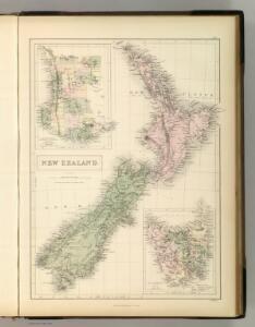
New Zealand. Plate 11, v.1
1 : 2500000 Bartholomew, John
Carte de la Nouvelle Zéelande
1 : 4450000 Cookovy ostrovy Bonne, Rigobert André
New Zealand.
1 : 2534400 Stanford, Edward
238. New Zealand, New Caledonia, Fiji. The World Atlas.
1 : 5000000 USSR (Union of Soviet Socialist Republics).
To the Right Honourable the Secretary of State for the Colonies, &c., &c., &c, this chart of New Zealand from original surveys is respectfully dedicated by his very obedient servant James Wyld
1 : 2500000 engraved by James Wyld [...] London : Wyld
Stille Zuid Zee No. 2
1 : 9000000 [Dordrecht : J. de Vos & Comp.
New Zealand
1 : 1415000 Auckland (Nový Zéland) Bacon, George Washington G.W. Bacon
CARTE de l'Ille D'IKA NA MAUWI
Severní ostrov (Nový Zéland) Blosseville, Jules de Eyries, Jean-Baptiste Benoît J.B. Eyries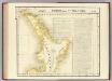
Partie, Nle. Zelande. Oceanque. no. 59.
1 : 1641836 Vandermaelen, Philippe, 1795-1869
Australia in 1839.
1 : 12700000 Society for the Diffusion of Useful Knowledge (Great Britain)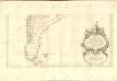
Amerique Meridionale [c]
1 : 6300000 Hoja del inferior del más importante y detallado mapa francés sobre Suramérica de mediados del siglo XVIII, elaborado por Jean Baptiste Bourguignon D’Anville, una de las autoridades cartográficas más trascendentales e influyentes de su tiempo. Esta parte del mapa muestra la región de las pampas y de la Patagonia, al extremo sur de América, en las actuales Chile y Argentina. El mapa enfatiza, con sus espacios en blanco, el carácter desconocido y salvaje de estas regiones, según los europeos. D’Anville registra las tensiones entre españoles e ingleses por las Islas Malvinas o Falkland. De particular interés resulta el cartucho decorativo, en la parte inferior del mapa: allí aparece una escena alegórica del dominio católico del subcontinente. Anville, Jean Baptiste Bourguignon d' (1697-1782) Delahaye, Guillaume-Nicolas (1727-1802)
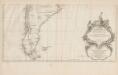
Chili et Argentine, Flle. Nord.
1 : 6000000 Vivien St Martin, L.
[Süd-Amerika in 6 Blättern, Blatt 6]
Adolf Stieler's Handatlas über alle Theile der Erde und über das Weltgebäude Stieler, Adolf Justus Perthes
[Süd-Amerika in 6 Blättern, Blatt 5]
Adolf Stieler's Handatlas über alle Theile der Erde und über das Weltgebäude Stieler, Adolf Justus Perthes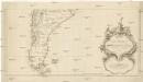
Karte von Süd-America
Jižní Amerika Anville, Jean-Baptiste Bourguinon d' Alberti, Ignaz F.A. Schraembl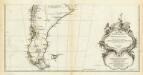
Amerique Meridionale. (Southern section)
1 : 6300000 Anville, Jean Baptiste Bourguignon d, 1697-1782
Patagonia. South Orkney or Powell's Group. Falkland Islands. South Georgia Island.
Colton, G.W.
Chili. [Karte], in: Gerardi Mercatoris et I. Hondii Newer Atlas, oder, Grosses Weltbuch, Bd. 2, S. 416.
1 Karte aus Atlas Mercator, Gerhard und Hondius, Jodocus Jansson, Jan
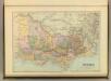
Victoria & Tasmania.
1 : 2500000 John Bartholomew & Co.
Victoria Or Port Phillip.
1 : 2977920 Tallis, J. & F.
Partie, (Chili, la Plata). Amer. Merid. 36.
1 : 1641836 Vandermaelen, Philippe, 1795-1869
Partie, la Plata. Amer. Merid. 37.
1 : 1641836 Vandermaelen, Philippe, 1795-1869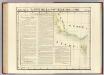
Partie, Nouvelle Hollande. Oceanique no. 56.
1 : 1641836 Vandermaelen, Philippe, 1795-1869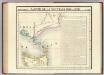
Partie, Nouvelle Hollande. Oceanique no. 57.
1 : 1641836 Vandermaelen, Philippe, 1795-1869
Partie, la Patagonie. Amer. Merid. 38.
1 : 1641836 Vandermaelen, Philippe, 1795-1869
Ile de Diemen. Oceanique no. 58.
1 : 1641836 Vandermaelen, Philippe, 1795-1869
State of Victoria