Maps of Merauke
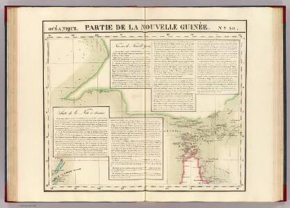
Partie, Nouvelle Guinee. Oceanique no. 30.
1 : 1641836 Vandermaelen, Philippe, 1795-1869
Geologische overzichtskaart van den Nederlandsch Oost-Indischen Archipel : Nederlandsch Nieuw Guinea [Zuid] / bewerkt door J. Zwierzycki
Landsdrukkerij Weltevreden (Batavia) [Weltevreden (Batavia) : Landsdrukkerij]
Daru / U.S. Army Map Service
U.S. Army Map Service Washington D.C. Washington D.C. : U.S. Army Map Service
Bladwijzer van Merauke en omgeving
[S.l. : s.n.]
Bian-Rivier / prepared and reproduced by Base Map Plant USASOS SWPA, December 1942 - January 1943, from a Dutch map printed by Topografische Dienst (Topographic Service) Batavia, 1941
Base Map Plant USASOS SWPA [S.l.] : Base Map Plant USASOS/SWPA
Merauke / prepared and reproduced by Base Map Plant USASOS SWPA, December 1942 - January 1943, from a Dutch map printed by Topografische Dienst (Topographic Service) Batavia, 1941
Base Map Plant USASOS SWPA [S.l.] : Base Map Plant USASOS SWPA
Merauke / Netherlands Topographic Service
Netherlands Topographic Service Delft [Delft] : Netherlands Topographic Service
Frederik-Hendrik-Eiland-Zuid / Netherlands Topographic Service
Netherlands Topographic Service Delft [Delft] : Netherlands Topographic Service
Frederik Hendrik-Eiland Noord / prepared and reproduced by Base Map Plant USASOS SWPA, December 1942 - January 1943, from a Dutch map printed by Topografische Dienst (Topographic Service) Batavia, 1941
Base Map Plant USASOS SWPA [S.l.] : Base Map Plant USASOS SWPA
Okaba / Netherlands Topographic Service
Netherlands Topographic Service Delft [Delft] : Netherlands Topographic Service
Dutch New Guinea : 1:250.000 / War Department, Washington D.C.. Corps of Engineers U.S. Army
Base Map Plant USASOS SWPA [S.l.] : Base Map Plant USASOS/SWPA
Frederik Hendrik-Eiland Zuid / published by Survey Directorate H[ead] Q[uarters] SEALF [=South East Asia Land Forces]
Survey Directorate Head Quarters South East Asia Land Forces (SEALF) [S.l.] : Survey Directorate H[ead] Q[uarters] SEALF [=South East Asia Land Forces]
Frederik Hendrik-eiland / Topografische Dienst
Topografische Dienst Delft [Delft] : Topografische Dienst
Digoel-Rivier / Netherlands Topographic Service
Netherlands Topographic Service Delft [Delft] : Netherlands Topographic Service
Bian-Rivier / Netherlands Topographic Service
Netherlands Topographic Service Delft [Delft] : Netherlands Topographic Service
Tanahmerah / prepared and reproduced by Base Map Plant USASOS/SWPA, December 1942 - January 1943, from a Dutch map printed by Topografische Dienst (Topographic Service) Batavia, 1940
Base Map Plant USASOS SWPA [S.l.] : Base Map Plant USASOS/SWPA
Digoel-Rivier / prepared and reproduced by Base Map Plant USASOS/SWPA, December 1942 - January 1943, from a Dutch map printed by Topografische Dienst (Topographic Service) Batavia, 1941
[S.l.] : Base Map Plant USASOS/SWPA
Cooks-Baai / published by Survey Directorate H[ead] Q[uarters] ALFSEA [=American Land Forces South East Asia]
Survey Directorate Head Quarters American Land Forces South East Asia [S.l.] : Survey Directorate H[ead] Q[uarters] ALFSEA [=American Land Forces South East Asia]
Cooks-Baai / Netherlands Topographic Service
Netherlands Topographic Service Delft [Delft] : Netherlands Topographic Service
Tanah Merah / Netherlands Topographic Service
Netherlands Topographic Service Delft [Delft] : Netherlands Topographic Service
Mappi-Rivier / Netherlands Topographic Service
Netherlands Topographic Service Delft [Delft] : Netherlands Topographic Service
Kondomiraf / Topografische Dienst
Topografische Dienst Delft [Delft] : Topografische Dienst
Gab-Gab meer / Topografische Dienst
Topografische Dienst Delft [Delft] : Topografische Dienst
Plan of Prince of Wales Group

Komolom / Topografische Dienst
Topografische Dienst Delft [Delft] : Topografische Dienst
Okaba / Topografische Dienst
Topografische Dienst Delft [Delft] : Topografische Dienst
Jera / Topografische Dienst
Topografische Dienst Delft [Delft] : Topografische Dienst
Pasirpoetih / Topografische Dienst
Topografische Dienst Delft [Delft] : Topografische Dienst
Boepoel / Topografische Dienst
Topografische Dienst Delft [Delft] : Topografische Dienst