Maps of Bougainville
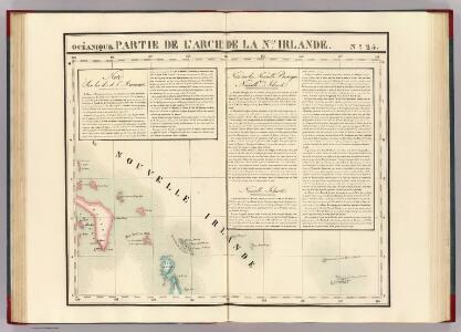
Partie, Nlle. Irlande. Oceanique no. 25.
1 : 1641836 Vandermaelen, Philippe, 1795-1869
Die deutschen Besitzungen im Stillen Ozean
1 : 3000000 Kiepert, Richard Geographische Verlagshandlung Dietrich Reimer
Kaiser-Wilhelmsland, Bismarck-Archipel, Salomon- und Marshall-Inseln
1 : 6000000 Bismarckovo souostroví F.A. Brockhaus' geogr.-artist. Anstalt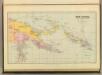
New Guinea & Solomon Islands.
1 : 5105520 Stanford, Edward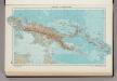
335. New Guinea, Solomon Islands. The World Atlas.
1 : 7500000 USSR (Union of Soviet Socialist Republics).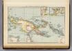
New Guinea, Papuan Archipelago.
1 : 10000000 Andree, Richard; Times (London, England)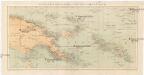
Kolonien (Schutzgebiete) des Deutschen Reichs
1 : 6000000 Marshallovy ostrovy F.A. Brockhaus Geogr.-artist. Anstalt
Nieuw Guinea en omgeving
1 : 8000000 Annotatie: Vrijgegeven door W.B.N. 29-3 '44 Den Haag : Kompas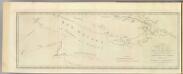
New Britain discoveries.
1 : 4500000 Hawkesworth, John, 1715?-1773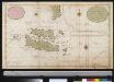
Nieuwe afteekeningh van Salomons Eijlanden of Isles de Salomon geleegen in de Groote Zuijd Zee. N.B. men segt dat de grond oft aertrijk deser eijlanden gout is
Solomon Islands Gerard van Keulen
Japanese aerodromes in Southwest Pacific Area, 20th November, 1944 / comp. by Allied Air Force SWPA
Allied Air Force SWPA [S.l.] : Allied Air Force SWPA

Australia and New Zealand.
1 : 16600000 Sharpe, J.
Uebersichts-Karte der ethnographischen Verhältnisse von Asien und von den angrenzenden Theilen Europa'sbearbeitet und herausgegeben mit Unterstützung der kaiserlichen Akademie der Wissenschaften in Wien von Vinzenz v. Haardt
Hartenthurn, Vincenz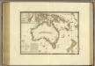
Australie.
1 : 17000000 Brue, Adrien Hubert, 1786-1832
East Indies from the best authorites
1 : 26000000
World War II Maps.
Hammond, C.S.
Tasman's kaart van zijn Australische ontdekkingen, 1644 / gereproduceerd op de ware grootte in goud en kleuren naar het orgineel, met tekst, door F.C. Wieder
Annotatie: Facsimile van de manuscriptkaart uit 1644, bewaard in de Mitchell Library, Sydney Frederik Casparus Wieder 1874-1943 's-Gravenhage : Nijhoff
Kaart van de afdeeling, eiland Saleijer (Silaijara), uit: Kaart van Zuid Celebes met uitzondering van het Rijk Gowa
1 : 200000 Annotatie: Met administratieve indeling 's-Gravenhage : Topographische Inrichting
Siam, Malacca and the Indian Islands.
from A new systeme of the mathematicks: containing I. Arithmetick, as well natural and decimal, as in species, or the principles of algebra. II. Practical geometry, together with the first six books of Euclid's Elements, as also the eleventh and twelfth, symbo
Carte marine des isles merid.les des Indes Orient.les et de la Nouv.e Hollande
1 Karte : Kupferdruck ; 41 x 48 cm Königliche Akademie der Wissenschaften
India quae Orientalis dicitur, et Insulae Adiacentes. [Karte], in: Novus atlas absolutissimus, Bd. 6, S. 144.
1 Karte aus Atlas Janssonius Offizin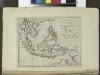
The islands of the East Indies with the channels between India, China & New Holland.
from Carey's general atlas, improved and enlarged : being a collection of maps of the world and quarters, their principal empires, kingdoms, &c.
India quae Orientalis dicitur, Et Insulae Adiacentes. [Karte], in: Theatrum orbis terrarum, sive, Atlas novus, Bd. 2, S. 248.
1 Karte aus Atlas Blaeu, Joan Blaeu, Willem Janszoon
India quae Orientalis dicitur, et Insulae Adiacentes. [Karte], in: Novus Atlas, das ist, Weltbeschreibung, Bd. 2, S. 263.
1 Karte aus Atlas Blaeu, Joan Blaeu, Willem Janszoon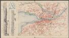
India quae Orientalis dicitur, Et Insulae Adiacentes. [Karte], in: Le théâtre du monde, ou, Nouvel atlas contenant les chartes et descriptions de tous les païs de la terre, Bd. 2, S. 239.
1 Karte aus Atlas Blaeu, Willem Janszoon und Blaeu, Joan Blaeu, Willem Janszoon
Australia and East Indies.
1 : 15000000 Johnson, A.J.
Far East, Mediterranean Area.
1 : 13000000 Sun Oil Company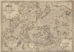
Indiae Orientalis, Insularumque Adiacientium Typus. [Karte], in: Theatrum orbis terrarum, S. 399.
1 Karte aus Atlas Ortelius, Abraham Vrients, Jan Baptista