Maps of Gander
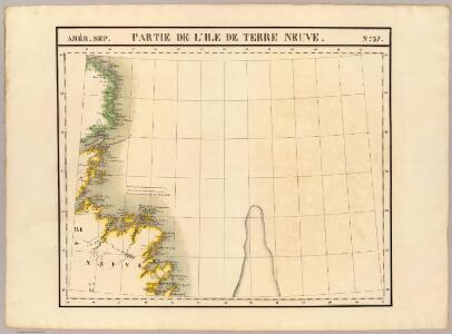
Partie, Ile de Terre Neuve. Amer. Sep. 37.
1 : 1641836 Vandermaelen, Philippe, 1795-1869
A Map of the British Empire in America. (Sheet 4).
1 : 2000000 Popple, Henry
HARBOR GRACE part of new found land; BAY BULLS part of new found land
from The sea-atlas : containing an hydrographical description of most of the sea-coasts of the known parts of the world.
Newfoundland.
1 : 1584000 Stanford, Edward
A General Chart Of The Island Of Newfoundland.
1 : 1280000 Jefferys, Thomas
Newfoundland.
1 : 1204000 Rand McNally and Company
Map of Newfoundland.
1 : 3900000 Morse, Jedidiah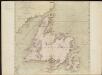
A general chart of the island of Newfoundland with the rocks & soundings
1 : 1280000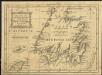
A new map of the only useful and frequented part of New Found Land
1 : 2800000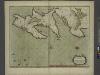
A new chart of the trading part of NEW FOUND LAND
from The sea-atlas : containing an hydrographical description of most of the sea-coasts of the known parts of the world.
Een gedeelte van de Oostkust van Labrador
Canada Johannes van Keulen
Newfoundland Nova Scotia And New Brunswick.
1 : 2787840 Burr, David H., 1803-1875
Ice Chart, Grand Banks Region, April.
U.S. Navy
Ice Chart, Grand Banks Region, December.
U.S. Navy
A New and correct map of the British colonies in North America comprehending eastern Canada with the province of Quebec, New Brunswick, Nova Scotia, and the Government of Newfoundland: with the adjacent states of New England, Vermont, New York, Pennsylvania and New Jersey.
from Charts and maps Publish'd by Laurie & Whittle, 53 Fleet Street: London; Robert Laurie and James Whittle,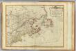
British colonies North America, New England.
1 : 3800000 Robert Laurie & James Whittle
A New and correct map of the British colonies in North America comprehending eastern Canada with the province of Quebec, New Brunswick, Nova Scotia, and the Government of Newfoundland: with the adjacent states of New England, Vermont, New York, Pennsylvania and New Jersey.
from John H. Levine Collection Publish'd by Laurie & Whittle, 53 Fleet Street: London; Robert Laurie and James Whittle,
Grand Banks Region, Index Chart for Ice Data Tables
U.S. Navy
Ice Chart, Grand Banks Region, May.
U.S. Navy
Ice Chart, Grand Banks Region, February.
U.S. Navy
Ice Chart, Grand Banks Region, June.
U.S. Navy
EXTREMA AMERICÆ | Versus Boream, ubi | TERRA NOVA | NOVA FRANCIA, Adjacentiaq.
Amstelaedami Io. Blaeu Exc.
Nova tabula geographica complectens borealiorem Americae partem : in qua exacte delineatae sunt Canada sive Nova Francia, Nova Scotia, Nova Anglia, Novum Belgium, Pensylvania, Virginia, Carolina et Terra Nova : cum omnibus littorum pulvinorumque profundi
from John H. Levine Collection
Ice Chart, Grand Banks Region, March.
U.S. Navy
Ice Chart, Grand Banks Region, August.
U.S. Navy
Ice Chart, Grand Banks Region, September.
U.S. Navy
Ice Chart, Grand Banks Region, November.
U.S. Navy
A new map of the British colonies in North America : shewing the seat of the present war, taken from the best surveys, compared with and improved from manuscripts of several noblemen and gentlemen / by John Andrews.
From Charts and maps
Ice Chart, Grand Banks Region, October.
U.S. Navy