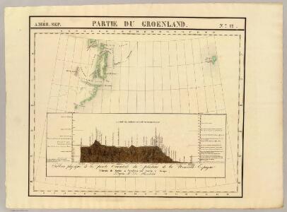
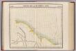
Maps of Jameson Land
Partie de Groenland. Amer. Sep. 12.
1 : 1641836 Vandermaelen, Philippe, 1795-1869
Spesielle kart 132: Jan Mayen nach der Aufnahme der Österreich arct
1 : 100000
Insulae Iohannis Mayen Cum universo situ Sinuum et Promontoriorum. Nova descriptio. [Karte], in: Novus atlas absolutissimus, Bd. 9, S. 176.
1 Karte aus Atlas Janssonius Offizin
INSVLA | QVÆ À | IOANNE MAYEN | NOMEN SORTITA EST.
[Amsterdam : Joan Blaeu]
Insulae Iohannis Mayen Cum universo situ Sinuum et Promontoriorum. [...] [Karte], in: Het vijfde Deel Des Grooten Atlas : Vervatende De Water-Weereld, S. 131.
1 Karte aus Atlas Jansson, Jan Jansson, Jan
Feuille 2 (B I), uit: Carte géologique internationale de l'Europe : la carte, votée au congrès géologique international de Bologne en 1881, est exécutée conformément aux décisions d'une commission internationale, avec le concours des gouvernements, sous le dir. de M.M. Beyrich et Hauchecorne
Annotatie: Blad 48 gamme des couleurs; blad 49: bladwijzer en titelblad Heinrich Ernst Beyrich 1815-1896; Wi. Hauchecorne Berlin : Reimer / (Berlin: Institut lithographique)
[II], uit: Geognostische Karte des Oesterreichischen Kaiserstaates mit einem grossen Theile Deutschland's u. Italien / hauptsachlich nach ... Haidinger's geognostischer Karte dieses Staates bearb. von Josef Scheda
1 : 3000000 titelvariant: General-Karte von Europa in 25 Blättern; Annotatie: Bijlage bij: General-Karte von Europa in 25 Blättern. - 1:2.592.000. - 1845-1847 Scheda, Joseph Wien : K.K. Militär. Geografisch. Institut
Carte d'Europe ou sont tracées les limites des empires, royaumes, et etats souverains, feuille 1
1 Blatt : 63 x 96 cm Semen etc
Evropa, 1
1 Blatt : mehrfarbig ; 49 x 57 cm Homännische Erben
Europe N.
1 : 4050000 Thomson, John
De custen van Noorwegen, Finmarken, Laplandt, Spitsbergen, Ian Maÿen Eÿlandt, Yslandt, als mede Hitlandt, en een gedeelte van Schotlandt
1 Karte : Kupferdruck ; 44 x 54 cm Doncker bÿ Hendrick Doncker boeckverkoper in de Nieubrugsteeg
Europa befolkningskarta
Partie, Russie d'Asie. Asie 11.
1 : 1641836 Vandermaelen, Philippe, 1795-1869
Carte réduite des mers du Nord
1 Karte : Kupferdruck ; 54 x 76 cm Verdun de la Crenne; Borda; Pingré; Petit s.n.
Vorstellung des Meers in Norden von Asien und America, nebst der Berechnung von dessen Grösse und Ausdehnung
Asie severní
Scandinavia.
1 : 9300000 Bowen, Emanuel
Gletscherkarte
Atlas der Geologie Zittel, K.v. ; Berghaus, Hermann Justus Perthes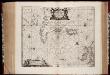
Typus Maritimus Groenlandiae, Islandiae, Freti Davidis, Insulae Iohannis Mayen, et Hitlandiae, Scotiae, et Hiberniae litora maritima Septentrionalia
1 : 7000000 Annotatie: Paskaart van de noordelijke Atlantische Oceaan met de kusten van met name het gebied tussen de Faeroër Eilanden, Groenland en Baffin Island; Origineel is Blad 149 in atlas factice; Kaart bevat diverse kompasrozen en is gedecoreerd met afbeeldingen van schepen en een walvis; Annotatie geografische gegevens: Met drie schaalstokken [Amstelodami] : [Apud Ioannem Ianßonium]
A General Chart ... Davis Straits & Baffin Islands Bay.
1 : 19000000 Melish, John
Septentrionalivm regionvm descrip
1 : 11050000 Evropa severozápadní
Septentrionalium regionum descriptio
1 : 28000000 1 Karte : Kupferdruck ; 8 x 11 cm Galle, Philippe [Christophe Plantin]
Swedland and Norway.
from A new systeme of the mathematicks: containing I. Arithmetick, as well natural and decimal, as in species, or the principles of algebra. II. Practical geometry, together with the first six books of Euclid's Elements, as also the eleventh and twelfth, symbo
Groenland und die angraenzenden Laender nach den Charten und Berichten von Cranz, Egede, Gieseke, Graah, Olavsen, Parry, Ross, Scoresby, Thorhallesen u.a.
1 : 5000000 entworfen und gezeichnet von Theodor Gliemann Weimar : Verlag des Geograph. Instituts
Pas-caerte van Groenlandt, Yslandt, Straet Davids en Ian Mayen Eylant
1 Karte : Kupferdruck ; 43 x 52 cm Doncker bÿ Hendrick Doncker boekverkoper en graadbooghmaker inde Nieubrughsteegh
Statistikk 38: Bosettingskart over Norge. Oversiktskart
Statistisk Sentralbyrå
(L'Europe)
1 : 100000000 Bruyset, Jean-Marie; Schneider, J. H.
Schweden und Norwegen, Dänemark, Island u. Faer-öer
Hand-Atlas über alle Theile der Erde nach dem neuesten Zustande und über das Weltgebäude Stieler, Adolf bei Justus Perthes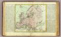
L'Europe isles, caps, ports.
1 : 13600000 Clouet, J. B. L. (Jean-Baptiste Louis), b. 1730
Evropa
Evropa z c. k. školního kněhoskladu