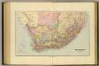
Maps of Eastern Cape

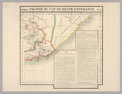
Cap de Bonne Esperance. Afrique 54.
1 : 1641836 Vandermaelen, Philippe, 1795-1869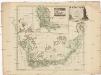
Carte von der südlichen Spitze von Africa bis zu dem Wendekreise des Steinbocks
Afrika jižní Forster, D. I. R. Sparrman, Anders in der A.G. Schneider und Weigelschen kaiserl. priv. Kunst- u. Buchhandlung
Charte der Südspize von Africa oder des Hottentotten und Caplands
Afrika jižní
CHARTE der SÜDSPIZE von AFRICA oder des HOTTENTOTTEN und CAPLANDS
Afrika jižní
Specialkarte der Südafrikanischen- (Transvaal) Republik

Union of South Africa Special Map Accompanying Richmond's South African All Mining Year Book (Sheet 2)
Union of South Africa. Special map accompanying Richmond's South African All Mining Year Book illustrating the location of Mines, Quarries and Works. Johannesburg : Hortors
Cape Province, Transvaal, &c. - eastern section.
1 : 2500000 John Bartholomew and Son
Cape Colony.
1 : 4200000 Arrowsmith, Aaron; Lewis, Samuel
Cape Colony.
1 : 4200000 Arrowsmith, Aaron; Lewis, Samuel
Natal And Kaffraria.
1 : 2640000 Tallis, J. & F.
Charte von dem Vorgebürge der guten Hoffnung: Nach John Barrow's Charte (London 1800 Sept. 1) reducirt
1 : 4100000 Landes-Industrie-Comptoir
Oranje-Freistaat, Kimberley, Colesberg, Dordrecht, Sterkstrom, u. s. w
1 : 800000 Afrika jižní Dietrich Reimer (Ernst Vohsen)
Ba-Souto mission area based on information provided by the missionaries of the Society of Evangelical Missions of Paris.

Southern Africa.
1 : 3100000 Hall, S. (Sidney)
South Africa, Cape Colony.
1 : 7180000 Higgins, W.M.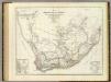
Sud. v. Africa.
1 : 3000000 Weiland, C. F. (Carl Ferdinand), d. 1847
South Africa.
1 : 10080000 Peterson, Augusts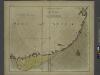
A draught of the south part of AFRICA from cape Bona Esperance to Delagoa
from The sea-atlas : containing an hydrographical description of most of the sea-coasts of the known parts of the world.
Das Capland nebst den süd-afrikanischen Freistaaten un dem Gebiet der Hottentotten & Kaffern.
South Africa.
1 : 5000000 John Bartholomew and Son
Politisch - militärische Karte von Süd-Afrika

[Kaart], uit: Karte des Afrikander-Aufstandes im Kaplande und des Angriffskrieges der Buren / Paul Langhans
1 : 4000000 titelvariant: Karte des Afrikander-Aufstandes im Kaplande; Annotatie: Omslagtitel: Karte des Afrikander-Aufstandes im Kaplande; Met portret van Christian de Wet Langhans, Paul Gotha : Perthes
Zuidelijkste gedeelte van Afrika of het land der Hottentotten : volgens de nieuwste waarneminghe opgesteld
1 : 15000000 Te Amsterdam : bij de Wed. van Esveldt en Holtrop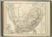
South Africa.
1 : 3817440 Johnston, W. & A.K.
Kaart van Zuid-Afrika / naar de laatste en beste bronnen bewerkt voor 'De worstelstrijd der Transvalers' door F. Lion Cachet, derde herziene druk ; A.J. Wendel grav
1 : 3000000 Annotatie geografische gegevens: Met schaalstok; Legenda Abraham Jacobus Wendel 1826-1915 Pretoria [etc.] : Boekhandel voorheen Höveker & Wormser / ([Leiden : P.W.M. Trap])
Topographical map of the Union of South Africa = Topografiese kaart van die Unie van Suid-Afrika / A.D. Lewis ; comp. in the Office of the Director of Irrigation
1 : 1500000 titelvariant: Topografiese kaart van die Unie van Suid-Afrika Lewis, A. D.; Office of the Director of Irrigation, Zuid-Afrika Pretoria : Government Printer
Süd-Afrika
Hand-Atlas über alle Theile der Erde nach dem neuesten Zustande und über das Weltgebäude Stieler, Adolf bei Justus Perthes
Mission map of South Africa according to the map in Stieler's Atlas

[Süd-Afrika]
Hand-Atlas über alle Theile der Erde nach dem neuesten Zustande und über das Weltgebäude Stieler, Adolf bei Justus Perthes