Maps of Puntland

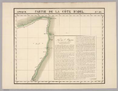
Partie, la Cote d'Adel. Afrique 34.
1 : 1641836 Vandermaelen, Philippe, 1795-1869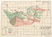
Plant ecology (Somalia)
[A collection of maps illustrating an economic survey and reconnaissance report on British Somaliland, G.P. numbers 2577 - 2593]. Great Britain. Army. East Africa Force. [S.l.] : 157 (E.A. & S.R.) Base Svy. Coy., E.A.E.
Le royaume d'Adel
1 : 9600000 Jemen Bonne, Rigobert André
Abessinien - Somaliländer
1 : 7500000 Etiopie Barich, Carl Justus Perthes
116-17. Eritrea, Etiopia, Somalia.
1 : 5000000 Touring club italiano
Ostafrika – Vých. Afrika

British Somaliland and Sokotra
in British Somaliland and Sokotra. [With a map.] iv, 40 p. ; 8 -- . Great Britain. Foreign Office. Historical Section.
Itinerari di due viaggi al Madagascar eseguiti dall'inge. E. Cortese nel 1887
1 : 1000000 Società geografica italiana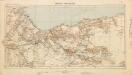
British Somaliland [showing routes] (1926)
British Somaliland [showing routes], GSGS 2991(b). Great Britain. General Staff. Geographical Section. [London] : [GSGS, War Office]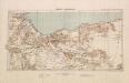
British Somaliland, GSGS 2991 (1922)
British Somaliland, GSGS 2991. Great Britain. General Staff. Geographical Section. [London] : [GSGS, War Office]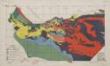
Soil map (Somalia)
[A collection of maps illustrating an economic survey and reconnaissance report on British Somaliland, G.P. numbers 2577 - 2593]. Great Britain. Army. East Africa Force. [S.l.] : 157 (E.A. & S.R.) Base Svy. Coy., E.A.E.
Untitled

Delineatio omnium orarum totius australis partis Americae, dictae Peruvianae, a R. de la Plata, Brasiliam, Pariam, & Castellam auream, una cum omnibus insulis Antillas dictis, Hispaniolam, item & Cubam comprehendentis, usq[ue] ad promont. Floridae, vulgo cabo de la Florida, item isthmi inter Panamam & Nombre de dios, terrae Peru auriferae, cum ejus metropoli Cusco & com[m]odissimo portu Limae. orarum etiam Chilae, freti inter terram Patagonum, & terram del fuego, vulgo Estre
Jižní Amerika Langren, Arnoldus Florentius De Laet, Johannes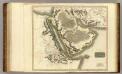
Arabia, Egypt, Abyssinia, Red Sea.
1 : 6500000 Thomson, John
Ost-Africa, Madagascar.
1 : 12900000 Radefeld, Carl Christian Franz, 1788-1874
Ost-Africa und Madagascar
Grosser Hand-Atlas über alle Theile der Erde in 170 Karten Meyer, J. Verlag des Bibliographischen Instituts
Prémière partie de la carte d'Asie : contenant la Turquie, l'Arabie, la Perse, l'Inde en deçu du Gange et de la Tartarie ce qui est limitrophe de la Perse et de l'Inde / par le Sr. d'Anville ; gravé par Guill. de-la-Haye
1 : 6650000 Annotatie: In: [Atlas du Sr. d'Anville], bl. 1 Anville, Jean Baptiste Bourguignon d'; Haye, Guill. de la A Paris : chez l'auteur

[Afrika, Blatt 4]
Adolf Stieler's Handatlas über alle Theile der Erde und über das Weltgebäude Stieler, Adolf Justus Perthes
Arabia.
1 : 13800000 Darton, William
Carte de l'Ethiopie Orientale située sur la Mer des Indes entre la Cap Guardasouin, & le Cap de Bonne Esperance
1 : 8500000 dressée sur les meilleurs memoires principalement sur ceux des Portugais par le Sr. d'Anville [...] aout 1727 Delahaye sculpsit [Paris] : le Sr. d'Anville
Geographie des Hebreux.
1 : 16800000 Malte-Brun, Conrad, 1775-1826
North Eastern Africa.
1 : 15000000 Colton, G.W.
North Eastern Africa.
1 : 15000000 Colton, G.W.
La table des peuples de Moise et geographie de la Genese.
1 : 14000000 Vivien de Saint-Martin, M.
North Eastern Africa.
1 : 15000000 Colton, G.W.
Carte des trois Arabies : tirée en partie de l'Arabe de Nubie, en partie de diuers autres autheurs
1 : 7500000 Sanson, Nicolas, 1600-1667 Chez Pierre Mariette
Tabula Asiae VI. [Karte], in: Claud. Ptolemaeus. Geographia lat. cum mappis [...], S. 311.
1 Karte aus Atlas Münster, Sebastian [und Ptolemaeus, Claudius]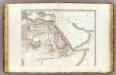
L'Afrique 2.
1 : 10000000 Brue, Adrien Hubert, 1786-1832