Maps of Somali Region

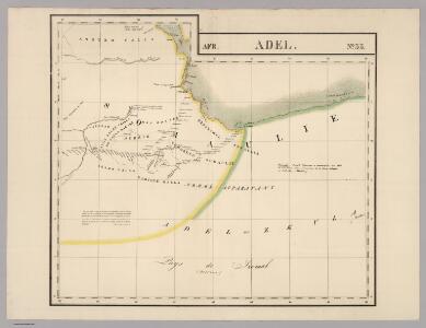
Adel. Afrique 33.
1 : 1641836 Vandermaelen, Philippe, 1795-1869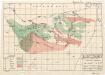
Plant ecology (Somalia)
[A collection of maps illustrating an economic survey and reconnaissance report on British Somaliland, G.P. numbers 2577 - 2593]. Great Britain. Army. East Africa Force. [S.l.] : 157 (E.A. & S.R.) Base Svy. Coy., E.A.E.
Carta dimostrativa della Etiopia (Sheet 6)
Carta dimostrativa della Etiopia, in 6 fogli e 2 aggiunte, alla scala di 1 : 100,000. Compilata dal Capitano ... Ethiopia de Chaurand, etc. [Rome]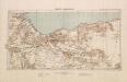
British Somaliland, GSGS 2991 (1922)
British Somaliland, GSGS 2991. Great Britain. General Staff. Geographical Section. [London] : [GSGS, War Office]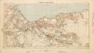
British Somaliland [showing routes] (1926)
British Somaliland [showing routes], GSGS 2991(b). Great Britain. General Staff. Geographical Section. [London] : [GSGS, War Office]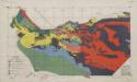
Soil map (Somalia)
[A collection of maps illustrating an economic survey and reconnaissance report on British Somaliland, G.P. numbers 2577 - 2593]. Great Britain. Army. East Africa Force. [S.l.] : 157 (E.A. & S.R.) Base Svy. Coy., E.A.E.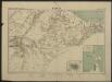
Carte de la côte française des Somalis et régions avoisinantes. Harrar
1 : 500000 Meunier, A., cartographe [Paris] : Service géographique des colonies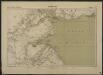
Carte de la côte française des Somalis et régions avoisinantes. Djibouti
1 : 500000 Meunier, A., cartographe [Paris] : Service géographique des colonies
Somaliland 1:250 000, Sa-Wer
Somaliland 1:250 000 , Series GSGS 3927. Series in seventeen sheets covers former British Somaliland only. Sheetlines based on grid. Sheets numbered consecutively; 1 to 17. Great Britain. War Office. General Staff. Geographical Section. [S.l.] : War Office.
Somaliland 1:250 000, Hargeisa
Somaliland 1:250 000 , Series GSGS 3927. Series in seventeen sheets covers former British Somaliland only. Sheetlines based on grid. Sheets numbered consecutively; 1 to 17. Great Britain. War Office. General Staff. Geographical Section. [S.l.] : War Office.
Somaliland 1:250 000, Tug Wajale
Somaliland 1:250 000 , Series GSGS 3927. Series in seventeen sheets covers former British Somaliland only. Sheetlines based on grid. Sheets numbered consecutively; 1 to 17. Great Britain. War Office. General Staff. Geographical Section. [S.l.] : War Office.
Somaliland 1:250 000, Berbera
Somaliland 1:250 000 , Series GSGS 3927. Series in seventeen sheets covers former British Somaliland only. Sheetlines based on grid. Sheets numbered consecutively; 1 to 17. Great Britain. War Office. General Staff. Geographical Section. [S.l.] : War Office.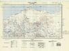
Somaliland 1:250 000, Las Dureh
Somaliland 1:250 000 , Series GSGS 3927. Series in seventeen sheets covers former British Somaliland only. Sheetlines based on grid. Sheets numbered consecutively; 1 to 17. Great Britain. War Office. General Staff. Geographical Section. [S.l.] : War Office.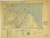
Somaliland 1:250 000, Zeila
Somaliland 1:250 000 , Series GSGS 3927. Series in seventeen sheets covers former British Somaliland only. Sheetlines based on grid. Sheets numbered consecutively; 1 to 17. Great Britain. War Office. General Staff. Geographical Section. [S.l.] : War Office.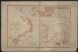
Port d'Obock et possessions françaises sur la mer Rouge
1 : 700000 Paris : Charles Bayle et Cie
1 : 125,000 Somaliland Protectorate. Geological Survey. D.C.S. 1076, Abdal Qadr
1 : 125,000 Somaliland Protectorate. Geological Survey. D.C.S. 1076. [Surbiton] : Directorate of Colonial Surveys
1 : 125,000 Somaliland Protectorate. Geological Survey. D.C.S. 1076, Heis Area
1 : 125,000 Somaliland Protectorate. Geological Survey. D.C.S. 1076. [Surbiton] : Directorate of Colonial Surveys
1 : 125,000 Somaliland Protectorate. Geological Survey. D.C.S. 1076, Sheikh
1 : 125,000 Somaliland Protectorate. Geological Survey. D.C.S. 1076. [Surbiton] : Directorate of Colonial Surveys
1 : 125,000 Somaliland Protectorate. Geological Survey. D.C.S. 1076, El Dur Elan
1 : 125,000 Somaliland Protectorate. Geological Survey. D.C.S. 1076. [Surbiton] : Directorate of Colonial Surveys
1 : 125,000 Somaliland Protectorate. Geological Survey. D.C.S. 1076, Las Dureh
1 : 125,000 Somaliland Protectorate. Geological Survey. D.C.S. 1076. [Surbiton] : Directorate of Colonial Surveys
1 : 125,000 Somaliland Protectorate. Geological Survey. D.C.S. 1076, Burao
1 : 125,000 Somaliland Protectorate. Geological Survey. D.C.S. 1076. [Surbiton] : Directorate of Colonial Surveys
1 : 125,000 Somaliland Protectorate. Geological Survey. D.C.S. 1076, Adadleh
1 : 125,000 Somaliland Protectorate. Geological Survey. D.C.S. 1076. [Surbiton] : Directorate of Colonial Surveys
1 : 125,000 Somaliland Protectorate. Geological Survey. D.C.S. 1076, Medishe
1 : 125,000 Somaliland Protectorate. Geological Survey. D.C.S. 1076. [Surbiton] : Directorate of Colonial Surveys
1 : 125,000 Somaliland Protectorate. Geological Survey. D.C.S. 1076, Habaji
1 : 125,000 Somaliland Protectorate. Geological Survey. D.C.S. 1076. [Surbiton] : Directorate of Colonial Surveys
1 : 125,000 Somaliland Protectorate. Geological Survey. D.C.S. 1076, Erigavo
1 : 125,000 Somaliland Protectorate. Geological Survey. D.C.S. 1076. [Surbiton] : Directorate of Colonial Surveys
1 : 125,000 Somaliland Protectorate. Geological Survey. D.C.S. 1076, Bawn
1 : 125,000 Somaliland Protectorate. Geological Survey. D.C.S. 1076. [Surbiton] : Directorate of Colonial Surveys
1 : 125,000 Somaliland Protectorate. Geological Survey. D.C.S. 1076, Qabri Bahar
1 : 125,000 Somaliland Protectorate. Geological Survey. D.C.S. 1076. [Surbiton] : Directorate of Colonial Surveys
1 : 125,000 Somaliland Protectorate. Geological Survey. D.C.S. 1076, Laferug
1 : 125,000 Somaliland Protectorate. Geological Survey. D.C.S. 1076. [Surbiton] : Directorate of Colonial Surveys
1 : 125,000 Somaliland Protectorate. Geological Survey. D.C.S. 1076, Gocti
1 : 125,000 Somaliland Protectorate. Geological Survey. D.C.S. 1076. [Surbiton] : Directorate of Colonial Surveys