Maps of Debubawi Keyih Bahri
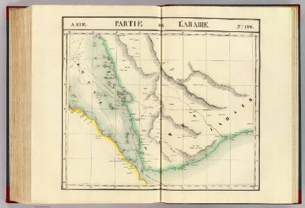
Partie, l'Arabie. Asie 100.
1 : 1641836 Vandermaelen, Philippe, 1795-1869
Fünf Karten zu C. Ritter ́s Erdkunde von Arabien

Terrae Yemen maxima Pars. seu Imperii Imami, Principatus Kaukebân, nec non ditionum Haschid U Bekîl, Nehhm, Chaulân, Abu Arîsch Et Aden Tabula : ex observationibus astronomicis et hodometricis jussu et suntibus Potentissimor: Daniae Regnum Friderici V et Christiani VII institutis
1 : 1250000 Niebuhr, Carsten, 1733-1815 Tob. Conr. Lotter
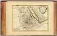
Terrae Yemen maxima pars, seu imperii Imami, principatus Kaukebân, nec non ditionum Haschid u Bekîl, Nehhm, Chaulân, Abu Arîsch et Aden, tabula : ex observationibus astronomicis et hodometricis jussu et sumtibus potentissimor. Daniae regum Friderici V, et Christiani VII. institutis, delineata
1 : 1200000 auctore C. Niebuhr Gustav Conrad Lotter sculps. Aug. Vind. : Tob. Conr: Lotter geogr. excud.
Karte von dem groessten Theil des Landes Jemen Imame, Kaukeban &
1 : 775000 Jemen Niebuhr, Carsten Benedicti, Hieronymus F.A. Schraembl
Carta dimostrativa della Etiopia (Sheet 1)
Carta dimostrativa della Etiopia, in 6 fogli e 2 aggiunte, alla scala di 1 : 100,000. Compilata dal Capitano ... Ethiopia de Chaurand, etc. [Rome]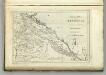
Map of Abyssinia.
1 : 1470000 Melish, John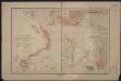
Port d'Obock et possessions françaises sur la mer Rouge
1 : 700000 Paris : Charles Bayle et Cie
Terrae Yemen
1 : 1130000 Jemen Niebuhr, Carsten Lotter, Gustav Konrad Tob. Conr. Lotter
1re partie de la Carte de la Mer Rouge
1 : 2500000 Rudé moře-oblast
Carta della colonia Eritrea
1 : 1500000 Italie. Ministero degli Affari esteri [Florence] : Ministero degli affari esteri
Carte d'Abyssinie et des contrées adjacentes dressée partie d'après des observations faites sur les lieux par l'auteur, partie d'après les informations prises dans le pays en 1809 et 1810
1 : 5000000 par Henry Salt [S.l.] : [s.n.]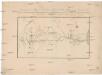
Carte der neuen Strasse von Villa de St. José do Porto-Alegre nach Minas Novas welche im Jahr 1816 durch die Wälder gebahnt ward vom Coronel Bento Lourenco Vaz de Abreu e Lima, Inspector dieser Strasse
Minas Novas (Brazílie) Kitschin, Thomas Brönner, Heinrich Ludwig Heinrich Ludwig Brönner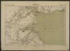
Carte de la côte française des Somalis et régions avoisinantes. Djibouti
1 : 500000 Meunier, A., cartographe [Paris] : Service géographique des colonies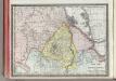
Upper Nubia and Habesh or Abyssina.
1 : 5000000 Rand McNally and Company
Abyssinië in vogelvlucht gezien = Abyssinie vue a vol d'oiseau / Seghers
titelvariant: Abyssinie vue a vol d'oiseau; Annotatie: Gegevens verzameld over de periode/Data collected over the period: 1935; With photographs of current world leaders; Fragment: foto's van wereldleiders ontbreken; Annotatie geografische gegevens: Bijkaart: Van Gibraltar tot Abessinië = De Gibraltar a l'Abessinie W. Seghers Antwerpen [etc.] : [Patria, etc.]
Programma di massima della triangolazione geodetica di I° ordine dell' altopiano etiopico
1 : 3000000 Eritrea Istituto geografico militare
Abessinien
1 : 5000000 Etiopie G. Freytag & Berndt
[Kaart], uit: Colonie dell'Africa Orientale Italiana
1 : 4000000 Annotatie: Ondertitel op omslag: Eritrea - Somalia Italiana - Etiopia - Somalia Francese e Britannica; Annotatie geografische gegevens: Inzetkrt.: [Omgevingskaart]. - 1:50.000.000 Milano : Vallardi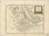
La Nubia ed Abissinia

Ostafrika – Vých. Afrika
Nubie, Abissinie.
1 : 7000000 Bonne, Rigobert, 1727-1794
Abessinien
1 : 5000000 Afrika východní Josef Ulbricht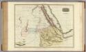
Abyssinia, Nubia &c.
1 : 4000000 Pinkerton, John, 1758-1826
116-17. Eritrea, Etiopia, Somalia.
1 : 5000000 Touring club italiano
Spezial-Karte von Afrika
1 : 4000000 Blatt 6 Habenicht, Hermann Perthes
Sudan and Ethiopia, Plate 87, V. IV
1 : 5000000 Bartholomew, John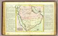
L'Arabie.
1 : 7000000 Clouet, J. B. L. (Jean-Baptiste Louis), b. 1730