Maps of Nepal
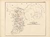
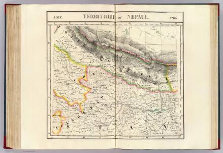
Nepaul. Asie 83.
1 : 1641836 Vandermaelen, Philippe, 1795-1869
India 10.
1 : 2217600 Letts, Son & Co.
India X.
1 : 2200000 Society for the Diffusion of Useful Knowledge (Great Britain)
Tingri Dzong
1 : 2500000 United States. Army Map Service. Army Map Service
Mustang
1 : 2500000 United States. Army Map Service. Army Map Service
No. 11. Rotasgur Fort. One of a series of plans of forts and passes on the W. border of Bihar, copied from the original by Lieut Robert Smith
Pen-and-ink and water-colour map of Rohtasgarh fort copied from the original by Lieut Robert Smith (1787-1873), c.1813. This is one of six plans of forts and passes on the west border of Bihar in the north east of India. Inscribed on the front of the folder in ink is: 'Plans of Forts & Passes on the South West Frontier of Bengal. Copied from the Original by Lieut. Robt. Smith of the Engineers.' Rohtasgarh is a hill fort near Sasaram, Bengal. It derives its name from the young prince Rohitaswa, son of Haris Chandra, king of the Solar race. Little is known of the fort until 1100 when it is supposed to have belonged to Pratap Dhawala, father of the last Hindu king. Sher Shah captured Rohtasgarh in 1539 and immediately began to strengthen the fortifications; but the work had not progressed far before he selected a new site at the place still known as Shergarh. Man Singh, Akbar's Hindu general, on being appointed viceroy of Bengal and Bihar selected Rohtasgarh as his stronghold. Smith, Robert (1787-1873), Artist
No. 3. Sohagee Pass. One of a series of plans of forts and passes on the W. border of Bihar, copied from the original by Lieut Robert Smith
Pen-and-ink and water-colour plan of a pass in the West of Bihar copied from the original by Lieut Robert Smith (1787-1873), c.1813. This is one of six plans of forts and passes on the west border of Bihar in the north east of India. Inscribed on the front of the folder in ink is: 'Plans of Forts & Passes on the South West Frontier of Bengal. Copied from the Original by Lieut. Robt. Smith of the Engineers.' Smith, Robert (1787-1873), Artist
Mount Everest and environs
1 : 126720 Himálaj (pohoří : oblast) Survey of India offices
Map of the confluence of the Barna and Ganges rivers with temples and the old fort on the left and brick kiln on the right, Benares
Pen and ink and watercolour map by James Prinsep (1799-1840), of the confluence of the Barna and Ganges rivers at Varanasi (Benares) in Uttar Pradesh, dated between 1822 and 1829. The map also shows temples, the old fort on the left and brick kiln on the right. James Prinsep came from a family who served in India for three generations; five of his brothers were also in the country. James, a noted scholar and antiquarian, was Assistant Assay Master at the old Calcutta Mint in 1819, and after occupying the position at the Benares Mint from 1820-30 finally became Assay Master of the Calcutta Mint in 1832. He also devised a plan to drain the unhealthy marshes and stagnant pools which formed around the most populated areas of Varanasi during the rainy season, by building a network of drains and a tunnel. These were considered a great feat of engineering. Prinsep, James (1799-1840), Artist
Map of the area around the Machhodri tank, Benares, with cross sections showing relative water levels of the marsh and the river, and the site of the proposed drain. With notes and measurements
Pen and ink and watercolour map by James Prinsep (1799-1840) of the area around the Machhodri tank at Varanasi (Benares) in Uttar Pradesh, dated between 1822 and 1829. The map contains cross sections showing the relative water levels of the marsh and the river, and the site of the proposed drain, and includes notes and measurements. Varanasi stands on the left bank of the Ganges and at its highest point stood well away from the river, but as the ground receded towards the water stagnant pools and marshes formed near the most densely inhabited areas during the rainy season and became a danger to health. Prinsep devised a plan to drain the city and built a network of drains and a tunnel which were considered a great feat of engineering. The sewers were opened in 1824 and the tunnel, in 1827. The Machhodri tank, drained by Prinsep, was formerly a marsh and later the site of a park and a grain market, the Bisheshwarganj, established in 1830. Prinsep came from a family who served in India for three generations; five of his brothers were also in the country. James, also a noted scholar and antiquarian, was Assistant Assay Master at the old Calcutta Mint in 1819, and after occupying the position at the Benares Mint from 1820-30 finally became Assay Master of the Calcutta Mint in 1832. Prinsep, James (1799-1840), Artist
Map and cross section of the drainage tunnel from the Machhodri tank to the river, Benares, with elevation and cross section of the tunnelling process and drawings of the equipment used
Pen and ink and watercolour map and cross section of the drainage tunnel from the Machhodri tank to the river at Varanasi (Benares) in Uttar Pradesh by James Prinsep (1799-1840), dated c. 1825. This image shows the elevation and cross section of the tunnelling process and drawings of the equipment used and is inscribed: 'Plan of the Mutsyoduree Tunnel. Proposed 30th April 1825. Sanctioned 2nd June 1825. Commenced masonry 1826. Completed 31 July 1827'. On the reverse of the map is an unfinished diagram. Varanasi stands on the left bank of the Ganges and at its highest point stood well away from the river, but as the ground receded towards the water stagnant pools and marshes formed near the most densely inhabited areas during the rainy season and became a danger to health. Prinsep devised a plan to drain the city and built a network of drains and a tunnel which were considered a great feat of engineering. The Machhodri tank, drained by Prinsep, was formerly a marsh and later the site of a park and a grain market, the Bisheshwarganj, established in 1830. Prinsep came from a family who served in India for three generations; five of his brothers were also in the country. James, also a noted scholar and antiquarian, was Assistant Assay Master at the old Calcutta Mint in 1819, and after occupying the position at the Benares Mint from 1820-30 finally became Assay Master of the Calcutta Mint in 1832. Prinsep, James (1799-1840), Artist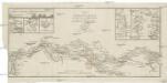
Charte vom Laufe des Ganges von Colgong bis Hurrisonker
1 : 400000 Ganga (Indie a Bangladéš : řeka) Colebrooke, R. H. im Verlage des Geograph. Instituts
District Maldah
Maps described in the 1878 published catalogue Survey of India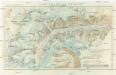
Karte des Zemu-Gletschers
1 : 33333 Himálaj (pohoří) Knorr & Hirth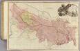
Bengal, Bahar, Oude, Allahabad.
1 : 1480000 Rennell, James, 1742-1830
Gangetic Hindoostan or the countries occupied by the Ganges and the branches
1 : 7000000 Cary, John, ca. 1754-1835 J. Cary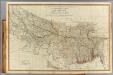
N. Hindostan.
1 : 1480000 Robert Laurie & James Whittle
Provinces of the Lower Ganges.
1 : 2000000 John Bartholomew & Co.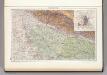
139. Upper Ganga (Ganges) Valley. Delhi. The World Atlas.
1 : 2500000 USSR (Union of Soviet Socialist Republics).
Composite: Delhi, Agrah, Oude, Ellahabad.
1 : 750000 Robert Laurie & James Whittle
North-Western Provinces, Oudh, and Nepal.
1 : 3990000 W. & A.K. Johnston Limited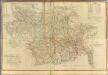
Composite: Bengal, Bahar &c.
1 : 750000 Robert Laurie & James Whittle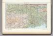
142. Lower Ganga (Ganges) Valley. The World Atlas.
1 : 2500000 USSR (Union of Soviet Socialist Republics).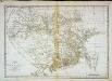
Carte du Bengale et de ses dépendances
1 Karte : Kupferdruck ; 37 x 53 cm Bolts s.n.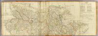
(Bengal, Bahar &c north)
1 : 750000 Robert Laurie & James Whittle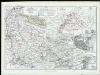
Die Missionsgebiete der Nordwest-Provinzen

India VII.
1 : 2200000 Society for the Diffusion of Useful Knowledge (Great Britain)
India 7.
1 : 2217600 Letts, Son & Co.
District Moorshedabad
India Office reference collection of maps Survey of India