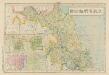
Maps of Jeollanam-do
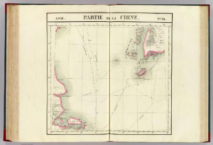
Partie, la Chine. Asie 74.
1 : 1641836 Vandermaelen, Philippe, 1795-1869
N.-Stiller Ocean. Chinesische Küste
N.-Stiller Ocean. Chinesische Küste. Gelbes Meer von Tsingtau bis Schanghai. Massstab, 1 : 1,000,000. Berlin : Reichs-Marine-Amt
韓國輿地圖:全羅道
Manuscript. Imprint date from postscript. 金鴻圭
輿地:全羅道
Not drawn to scale. 1 ms. atlas ([5] folded leaves of plates) : 5 col. maps ; 32 cm. Cover title. Relief shown pictorially. Brush-and-ink and watercolor
天下輿地圖:全羅道
天下輿地圖 明清时期 该图集为李氏朝鲜时期舆图,前有《天下圖》和《中國圖》各一幅,后为朝鲜八道图及日本图。封面题有“玄黓執徐腊下瀚”,可能是壬辰年十二月下旬,但具体年份待定。内容与形态基本与上图相同(005833853),《天下圖》反映中国传统天下观,中国居中,周围岛国取自《山海经》,《中國圖》绘制明朝两京十三省。 1图,彩绘,中文,图幅27.8 x 34.3 cm。 Harvard-Yenching | Rare Book | TK 3490.7 1174;Hollis Number:009140732
Lü-ssu-chen
1 : 2500000 United States. Army Map Service. Army Map Service
Shang-hai, East
1 : 2500000 United States. Army Map Service. Army Map Service
Shanghai area, GSGS 3837
Shanghai area, GSGS 3837. Great Britain. War Office. General Staff. Geographical Section. [S.l.] : [GSGS, War Office]
Shanghai & neighbourhood, GSGS 2386.
Shanghai & neighbourhood, GSGS 2386. Great Britain. General Staff. Geographical Section. [London] : [GSGS, War Office]
Shanghai, China, and vicinity
Shanghai, Maps, Map, Asia, China, and vicinity, including parts of Kiangsu and Chekiang provinces : approximately extends from 300̊0' to 314̊1' N. lat. and from 1200̊0' to 1220̊0' E. long / under direction of The Military Information Division, Manila, P.I. United States. Army. General Staff. Military Intelligence Division. [Manila?] : Military Intelligence Division, General Staff
Shanghai, OR 326.
Shanghai, OR 326. Great Britain. Ordnance Survey. London : War Office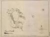
Port Hamilton Surveyed by Sir E Belcher 1845
[Port Hamilton. Surveyed by Sir E. Belcher ... 1845. [Admiralty Chart]] London
Shanghai Harbour (1877)
Shanghai Harbour. Surveyed by A.M. Bisbee, assisted by W.F. Stevenson. [Admiralty Chart] London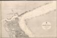
Shanghai Harbour(1868)
Shanghai Harbour. Surveyed by S.A. Viguier and J.M. Hockly ... 1866. The Town of Shanghai from a French Plan 1861. [Admiralty Chart] London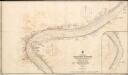
China East Coast Wusung River Shanghai Harbour (1900)
China. East Coast. Wusung River. Shanghai Harbour. Surveyed ... 1894. Soundings above Lu Kah Du Creek ... 1899. Revised and corrected to 1900 ... Natural scale 1 : 7,220. London : Admiralty
Shanghai Harbour (1889)
Shanghai Harbour. Surveyed ... 1887. Natural scale, 1 : 7,217. [Admiralty Chart] London
蘇城廂圖
1 : 8000 蘇城廂圖 清后期 绘制苏州城内各巷道、府署衙门、寺庙、书院、桥梁等。此图只绘制了娄、齐、葑、阊、胥、盘6城门,为清晚期的城门格局。 1图,墨刻本,中文,59 x 54cm,计里画方。 Harvard-Yenching | Rare Book | T 3099 2406,Hollis Number:009406209 缺
Ting-hai
1 : 2500000 United States. Army Map Service. Army Map Service
Nan-t'ung
1 : 2500000 United States. Army Map Service. Army Map Service
Shang-hai, West
1 : 2500000 United States. Army Map Service. Army Map Service
Yen-ch'eng
1 : 2500000 United States. Army Map Service. Army Map Service
Pa-t'an
1 : 2500000 United States. Army Map Service. Army Map Service
Ling-shan-wei
1 : 2500000 United States. Army Map Service. Army Map Service
Hang-chou
1 : 2500000 United States. Army Map Service. Army Map Service
Coree.
1 : 152000 La Perouse, Jean-Francois de Galaup, comte de, 1741-1788
Karte von Korea

七省沿海形勝圖 : 東楮島至吳淞口
1 : 1500000 七省沿海形勝圖 民国十五年(1926年)再版,童世亨,上海:商務印書館 此图资料来自山阴朱吉臣在沿海地区进行的实地勘察,但图未及出版,朱吉臣便离世,勘察手稿经交由童世亨,但不幸在日本遗失,仅留部分,后童世亨根据日本邮船会所刊行的航海图,结合朱吉臣残稿及浙江、福建、广东舆图整理绘制成此图。民国三年初版,十五年再版。共有5图:1、《自鴨綠江至東楮島》, 2、《自東楮島至吳淞口》, 3、《自吳淞口至南日嶼》,4、《自南日嶼至三夾口》,5、《自三夾口至白龍尾》,北起鸭绿江,一路南下经辽东半岛、渤海湾、山东半岛、江苏、浙江、福建、广东沿海,过雷州半岛至北部湾,涵盖整个中国东部海岸地带,细致绘制了海岸线和海岛。标注了涨潮和退潮方向、水道、灯塔、灯船、浮筒灯,并用绿色数字标注近海各处的水深。同时,以插图形式绘制了沿海主要港口、河口、海湾和城市,包括《旅順口分圖》《威海衛分圖》《膠州灣分圖》《雲台山分圖》《鎮江分圖》《江陰分圖》《吳淞口分圖》《舟山群島及象山港分圖》《三門灣分圖》《甌江口分圖》《沙埕港分圖》《三都墺分圖》《閩江口分圖》《廈門港分圖》《汕頭港分圖》《香港九龍分圖》《澳門附近分圖》《廣州附近分圖》及《廣州灣分圖》。用红色字体标注港口被列强侵占的情况。 5图,彩印,中文,39.5 x 54.5 cm,约1:1,500,000,E108°-124°/ N16°-41° Harvard-Yenching | 3080 0140.49 Oversize;Hollis Number:009201036 童世亨 上海:商務印書館
韓國輿地圖:東國
Manuscript. Imprint date from postscript. 金鴻圭
Korea oder Tscho-Sen der Japaner
1 : 1700000 Korea Satow, Ernest Mason Hassenstein, Bruno Justus Perthes