Maps of Tarim Basin
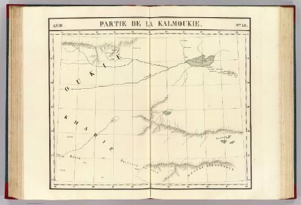
Partie, la Kalmoukie. Asie 56.
1 : 1641836 Vandermaelen, Philippe, 1795-1869
Die Staaten von Missouri Illinois, Indiana, Ohio, Kentucky & Tennessee
Cincinnati (Ohio) Scherer, Heinrich Kleinknecht
120-121. China, West. The World Atlas.
1 : 5000000 USSR (Union of Soviet Socialist Republics).
Central Asia
1 : 4000000 Asie střední War Office
Central Asia
1 : 4000000 Asie střední War Office
Das Himálaja Gebirg in Bissahir, Gherwal & Kemaun, von Südrande des Plateaus von Mittel-Tibet bis zum Tieflande von Hindostan
1 : 900000 Himálaj Grimm, J. L. Etzel, Franz August von C. Ritter und F.A. O'etzel
Das Himalaja Gebirg in Bissahir, Gherwal & Kemaun, von Südrande des Plateaus von Mittel-Tibet bis zum Tieflande von Hindostan
1 : 900000 Himálaj Grimm, J. L. Etzel, Franz August von C. Ritter und F.A. O'etzel
Charte von den Vereinigten Staaten von Nord-America mit Luisiana.
Spojené státy americké-oblast východní Martius, C. von Löwenberg, J.
[Indien & Inner-Asien, Nördliches Blatt]
Handatlas über alle Theile der Erde und über das Weltgebäude Stieler, Adolf Justus Perthes
Carte des Etats-Unis d'Amérique, et du cours du Mississippi
Spojené státy americké-oblast východní Brion de La Tour, Louis Homann, Johann Baptist Esnauts et Rapilly
Inner-Asien & Indien, Nördliches Blatt
Adolf Stieler's Handatlas über alle Theile der Erde und über das Weltgebäude Stieler, Adolf Justus Perthes
Turkestan.
1 : 5000000 Vivien St Martin, L.
地圖綜要 : 三卷(遠北西番諸夷圖)
地圖綜要 南明弘光元年(1645),吴学俨等编纂,李釜源鉴定,朗润堂藏板。 该书为明末军事防务地图集,涉及诸多江防、海防、边防等相关地图和解说,军事意味明显,这与成书背景有密切关系。该书在江南刊刻成书之际,清军已大举入关,大明王朝覆灭,仅剩南明小王朝残喘于南方,军事防务至关重要。也因其明显的南明立场,该书被列为四库禁毁书。全书分总卷、内卷和外卷三部分。燕京藏本共八册,书前序言、凡例和目录的总卷部分缺失。 总卷论及大明疆域沿革、军事防守要害、各省道里等内容,地图有《華夷古今形勝圖》,未画方,标绘各府所在,在空白处标注史地简介;《天下各鎮各邊要圖》,未画方,标注北方边防各山口关隘、东南海防、西南边防等;《京省合宿分界圖》,未画方,图上方标注各星宿,对应大明各府州;《天下輿地分里總圖》,计里画方,每方五百里,绘制两京十三省各府所在地。 内卷为两京十三省的建置总数、分里图、分界图、各府州县志、总论及事宜,其中,建制总数包括府州县卫所及各类机构数量、户数、口数、税、钞、丝、绢、盐、马草等数量;分里图采用计里画方,分别绘制两京十三省各府、州、县、卫所及山川河流名;分界图则以突出府界和州县的相对位置,并不追求里程的准确性,因此,与分里图相比,不仅删去了山川地名和解说,而且地图变形较大,以便于较为疏朗地标注各府州县地名;各府州县志则包括省内各府的山川河流、土产古迹、名宦人物等通常为方志所记载的内容;总论高度概括各地历史和地理形势;事宜则多论及该地的军事守备要领。每省分里图和分界图各一幅。 外卷主要为江防、海防、边防相关地图和图说。包括《長江會源分里全圖》《江防全圖》《漕河分里圖》《黃河分里圖》《海防全圖》《日本島夷入寇要害圖》《海運分里圖》《九邊總圖》及九边分图《遼東沿邊圖》《薊鎮沿邊圖》《宣府沿邊圖》《大同沿邊圖》《山西沿邊圖》《大同山西二邊分里合圖》《延綏沿邊圖》《寧夏沿邊圖》《固原沿邊圖》《甘肅沿邊圖》《四夷總圖》及四夷分图《東北諸夷圖》《朝鮮圖》《日本圖》《琉球圖》《東南海夷圖》《東南濱海諸夷圖》《西南海夷圖》《安南圖》《迤北西番諸夷圖》《西域圖》《朔漠圖》等。 在外卷诸图中,以《江防全圖》规模最大、绘制最为详细,并附有详细的解说,显然,这与当时南明小王朝偏居南方的局势密切相关,天堑长江实际上已经成为南明小王朝最后的屏障。 在图例上,府用正方形,州用菱形(包括土州),县用椭圆,卫所用椭圆外加四方短线,但图上大多数卫所并没有标志。 李釜源名茹春,崇祯十年(1637 年)进士,知华亭县。 《中國古籍善本書目》著录。 8册64图,墨刻本,中文,尺寸24.7 x 16.3 cm,计里画方。 Harvard-Yenching | Rare Book | T 3080.7 2925,Harvard-Yenching | Microfilm | FC9113, Master Microforms | Offsite Storage | Film Mas 34483;Hollis Number:008094513 吴学俨等 朗润堂
Nord-Indien
1 : 4000000 Indie severní War Office
Partie occidentale de la Nouvelle France ou du Canada
Velká kanadská jezera (Kanada a Spojené státy americké) Bellin, Jacques-Nicolas Berra, Marco par le Heritiers de Homan
Eastern Turkistan
1 : 2027520 Survey of India Survey of India
Indien & Inner-Asien, Nordliches Blatt.
1 : 7500000 Petermann, A.
Map of China
Diakoff, John A.
Greece and the Aegean.
1 : 2000000 John Bartholomew and Son
Map of High Asia

Density of the population in Peninsular India

Höhen-Verhältnisse vom östlichen Hochasien
1 : 6200000 Asie východní Grimm, J. L. Scharrer, W.
Hindostan or British India.
1 : 10000000 Colton, G.W.
Magni Mogolis imperivm
1 : 6940000 Mongolsko Wit, Frederick de I. Covens & C. Mortier
China.
1 : 10000000 Colton, G.W.
Decima Asie Tabula [Karte], in: [Clavdii Ptholomei Cosmographi ...], S. 329.
1 Karte aus Atlas Nicolaus Germanus [und Ptolemaeus, Claudius]
China.
1 : 5500000 Thomson, John
Inde. Asie Centrale.
1 : 10806700 Migeon, J.
China
1 : 9500000