Maps of Paramushir
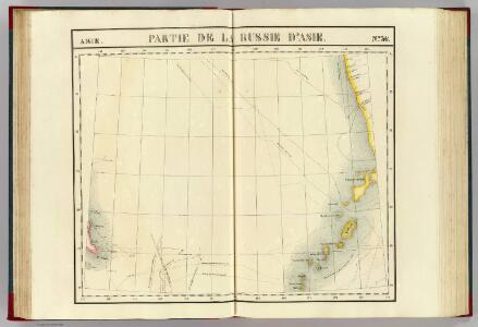
Partie de la Russie d'Asie. Asie 36.
1 : 1641836 Vandermaelen, Philippe, 1795-1869
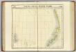
Iles Kuriles, Aleutiennes.
1 : 1900000 La Perouse, Jean-Francois de Galaup, comte de, 1741-1788
Plan of the Kurile Islands.
La Perouse, Jean-Francois de Galaup, comte de, 1741-1788
Kamschatka
1 : 4000000 Kamčatka (Rusko)
Karte von Jesso und Sagalien
Hokkaidó (Japonsko)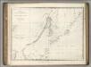
Chart of Discoveries, Made in 1787, in the Seas of China and Tartary, Sheet II.
1 : 6050000 La Perouse, Jean-Francois de Galaup, comte de, 1741-1788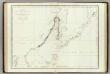
Mers, Chine, Tartarie. 2.
1 : 6250000 La Perouse, Jean-Francois de Galaup, comte de, 1741-1788
Ice Chart, Okhotsk Sea Region, August.
U.S. Navy
Ice Chart, Okhotsk Sea Region, June.
U.S. Navy
Ice Chart, Okhotsk Sea Region, March.
U.S. Navy
Manchuria
1 : 4000000 Mandžusko (Čína) War Office
Manchuria
1 : 4000000 Mandžusko (Čína) Royal Geographical Society
Ice Chart, Okhotsk Sea Region, January.
U.S. Navy
Ice Chart, Okhotsk Sea Region, November.
U.S. Navy
Ice Chart, Okhotsk Sea Region, April
U.S. Navy
Ice Chart, Okhotsk Sea Region, October.
U.S. Navy
Ice Chart, Okhotsk Sea Region, February.
U.S. Navy
Ice Chart, Okhotsk Sea Region, December.
U.S. Navy
Ice Chart, Okhotsk Sea Region, May.
U.S. Navy
Ice Chart, Okhotsk Sea Region, July.
U.S. Navy
Charte von der Nordwestküste Americas nach Vancouver
Vancouver-oblast (Britská Kolumbie) Martius, C. von Schwarzmann, I.
Japan, Mandshuria (showing the course of the Amur river), the Kurile Isles &c. : according to the British & Russian Admiralty surveys, Krusenstern, Siebold &c. / by J. Bartholomew Jun.r ; engraved by J. Bartholomew
1 : 9000000 titelvariant: Islands of Japan; Annotatie: Uit: The Royal illustrated atlas of modern geography. - London [etc.] : A. Fullarton & Co., 1860; Lit: A list of geographical atlases, I, no. 838; Titel boven de kaart: Islands of Japan Bartholomew, John (1831-1893) Edinburgh [etc.] : A. Fullarton & Co.
[Kaart], uit: Ezo kōkyō yochi zenzu
1 : 1200000 Edo : Harimaya Katsugorō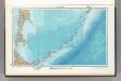
45. Kuril Islands. The World Atlas.
1 : 3000000 USSR (Union of Soviet Socialist Republics).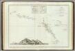
Decouvertes nord du Japon.
1 : 2800000 Vries, Maarten Gerritszoon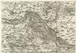
Archiducatus Austriae inferioris Geographica, et Nouiter Emendata Accuratissima Descriptio :
1 : 153333 Mollova mapová sbírka Vischer, Georg Matthaeus Hoffmann, Jakob
Islands of Japan.
1 : 8553600 Fullarton, A. & Co.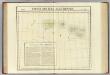
Partie, Iles Aleutiennes. Asie 38.
1 : 1641836 Vandermaelen, Philippe, 1795-1869
Suite de la carte de la Sibérie et le pays de Kamtschatka
1 : 14500000 1 Karte : Kupferdruck ; 23 x 25 cm [Bellin]