Maps of Kalmyk

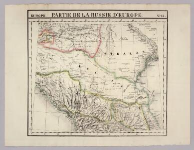
Partie, Russie d'Europe. Europe 23.
1 : 1641836 Vandermaelen, Philippe, 1795-1869
Mapa ruské národnosti na severním Kavkazsku
1 : 1080000 Kavkaz-oblast Chotek, Karel Česká společnost zeměvědná
Karta teatra vojny s Turcieju
1 : 350000 1 Karte : mehrfarbig ; 56 x 80 cm Kartograf. zavod A. Ilʹina
Partie des Gouvernemens d'Astracan et de Woronez; le Kabarda et partie du païs des Cosaques du Don
1 : 1400000 1 Karte : Kupferdruck ; 40 x 53 cm Rizzi-Zannoni, Giovanni Antonio [Santini-Remondini]
Plan des nivellirten Landstrichs zwischen dem schwarzen und caspischen Meere
1 : 1760000 Kaspické moře-oblast Reisen, E. Ramberg, F.
Lěvyj flang Kavkazckoj linīi v 1848 godu.
Aserbaidschan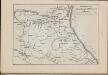
Operacīonnaja karta voennych dějstvīj A. P. Ermolova na Kavkazě
Russland Dagestan Ermolov, Alexej Petrovič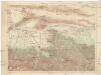
[Vladikavkaz]
1 : 210000 Severní Osetie-Alanie (Rusko)
Carte des embouchures du Tanais et des environs depuis Taigan, jusqu'a Nova-Krepa / Croisey scul.
1 : 310000 1 Karte : Kupferdruck ; 17 x 23 cm Bellin, Jacques Nicolas [Bellin]
Plan d'Azak où Azof / Croisey scul.
1 : 35000 1 Karte : Kupferdruck ; 21 x 16 cm Bellin, Jacques Nicolas [Bellin]
Plan osady Achul'go
Russland Dagestan Ashil'ta Belagerung
Moscowitische belagerung und Eroberung der Haubt-Stadt Asoff, im Tartarischen Königreich Nagaja am
1 Vogelschaukt. : Kupferdruck ; 26 x 34 cm Merian, Caspar [Merian's Erben]
Wolga-Delta
1 : 2000000 Wolgadelta
General Charte der Laender Zwischen dem Schwarzen und Caspischen Meere : Circassien, Georgien, Armenien, Wüste von Astrachan und Caucasus hauptsoechlich die Grosse und Kleine Kabarda
1 : 1750000 Treuttel, Jean-Georges, 1744-1826 Joh. Georg Treuttel
Russia at the Caucasus.
1 : 3380000 Sharpe, J.
Uebersichts Karte der russischen Provinzen nördlich und südlich vom Kaukasus
1 : 2900000 Kavkaz (pohoří : oblast) Literarisch artistische Anstalt
Russia 9.
1 : 3421400 Letts, Son & Co.
Russia in Europe Part IX and Georgia.
1 : 3500000 Society for the Diffusion of Useful Knowledge (Great Britain)
Russia in Europe part IX and Georgia / published under the superintendence of the Society for the Di
1 : 3500000 1 Karte : Kupferdruck ; 31 x 38 cm Walker, John by Baldwin and Cradock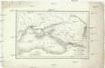
Carte du pourtour septentrional de la Mer Noire
1 : 5000000 Černé moře-oblast Lapie, Pierre Arnoul Firmin Didot
Uebersichts Karte der Russischen Provinzen nördlich und südlich vom Kaukasus
1 : 2500000 München : in der literarisch artistischen Anstalt
Uebersichts Karte der russischen Provinzen nördlich und südlich vom Kaukasus
1 : 2900000 1 Karte : Kupferdruck ; 42 x 47 cm in der literarisch artistischen Anstalt
Nowaja Semlja zum Gouv. Archangelsk gehörig
1 : 8000000 1 Karte : Lithographie ; 26 x 19 cm Schlieben, W.E.A. von [Georg Joachim Göschen]
XXXX. Panzerkorps vom 30. 6. bis 30. 9. 1942
1 : 2500000 Kavkaz-oblast Korpskartenstelle
[Ost-Europa, Blatt 6]
Adolf Stieler's Handatlas über alle Theile der Erde und über das Weltgebäude Stieler, Adolf Justus Perthes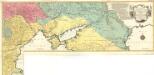
Carte Geographique representant le Théatre de la Guerre entre les Russes les Turcs, et les Polonois Confédérés
1 : 1600000 Mollova mapová sbírka Lotter, Tobias Conrad Lotter, Georg F. Lotter, Tobias Conrad
Carte générale du pays entre les mers Noire et Caspienne
1 : 2300000 Kaspické moře-oblast Darmet, J.M. Damas, Ange Hyacinthe Maxence de
Reliefkarte des Schwarzen Meeres, einschließlich der Dardanellen und der Kaukasus
Dardanely (Turecko : průliv) Franckh'sche Verlagshandlung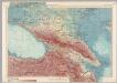
U.S.S.R. - Caucasia. Pergamon World Atlas.
1 : 2500000 Polish Army Topography Service
Charte der Laender am Caucasus
1 : 2100000 Kavkaz (pohoří : oblast) Reinecke, Johann Christoph Matthias