Maps of Scandinavia

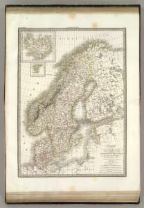
La Scandinavie.
1 : 4200000 Lapie, M. (Pierre), 1779-1850
Spesielle kart 129-3: Oversigtskart over fà ̧rste ordens trianguleringen og præcisionsnivellementet
1 : 2800000
Nástěnná mapa Evropy

Suede, Danemark.
1 : 4650000 Andriveau-Goujon, J.
Spesielle kart 130-2: Oversigt over tætbebyggelse, stà ̧rre industrielle bedrifter og vigtige gruber ...
1 : 2800000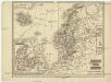
Schweden und Norwegen
1 : 11400000 Dánsko

Nordeuropa 1937
Nordeuropa Kunz, Andreas ; Treiling, Thomas
Suecia, Dania, Et Norvegia, Regna Europae Septentrionalia. [Karte], in: Le théâtre du monde, ou, Nouvel atlas contenant les chartes et descriptions de tous les païs de la terre, Bd. 1, S. 55.
1 Karte aus Atlas Blaeu, Willem Janszoon und Blaeu, Joan Blaeu, Willem Janszoon
Nieuwe kaart van Noord-Europa / door A. de Moor
1 : 3250000 Moor, A. de (fl. 1920) [S.l. : Zijlstra]
Nordeuropa 1814
Nordeuropa Kunz, Andreas ; Treiling, Thomas
Suecia, Dania, Et Norvegia, Regna Europae Septentrionalia. [...] [Karte], in: Theatrum orbis terrarum, sive, Atlas novus, Bd. 1, S. 53.
1 Karte aus Atlas Blaeu, Joan Blaeu, Willem Janszoon
Sweden, Denmark, Norway and Finland.
1 : 6336000 Carey, Mathew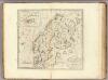
Sweden, Denmark, Norway and Finland.
1 : 8236800 Carey, Mathew
Sweden, Denmark, Norway and Finland.
1 : 8236800 Carey, Mathew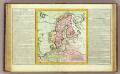
Suede, Dannemarck, Norwege.
1 : 8500000 Clouet, J. B. L. (Jean-Baptiste Louis), b. 1730
Nordeuropa 1809
Nordeuropa Kunz, Andreas ; Treiling, Thomas
Carte generale de toute l'Europe, 2
1 Blatt : 56 x 46 cm J.M. Will
Nordeuropa 1905
Nordeuropa Kunz, Andreas ; Röss, Wolf ; Johnen, Bettina ; Moeschl, Joachim Robert
Sweden, Denmark, Norway and Finland.
1 : 6400000 Carey, Mathew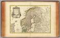
Suede, Danemarck et Norwege.
1 : 6900000 Janvier, Jean
Nordeuropa 1871
Nordeuropa Kunz, Andreas ; Röss, Wolf ; Johnen, Bettina ; Moeschl, Joachim Robert
Nordeuropa 1949
Nordeuropa Kunz, Andreas ; Treiling, Thomas
Nordeuropa 1820
Nordeuropa Kunz, Andreas ; Röss, Wolf ; Johnen, Bettina ; Moeschl, Joachim Robert
Statistikk 42: Døgnets normaltemperatur i Skandinavia, januar måned
1 : 4000000
Svecia, Dania, Et Norvegia, Regna Europae Septentrionalia [Karte], in: Novus Atlas, das ist, Weltbeschreibung, Bd. 1, S. 39.
1 Karte aus Atlas Blaeu, Joan Blaeu, Willem Janszoon
Nordeuropa 1815
Nordeuropa Kunz, Andreas ; Treiling, Thomas
Neueste Karte von Schweden und Norwegen
Grosser Hand-Atlas über alle Theile der Erde in 170 Karten Meyer, J. Verlag des Bibliographischen Instituts
Nordeuropa 1914
Nordeuropa Kunz, Andreas ; Röss, Wolf ; Johnen, Bettina ; Moeschl, Joachim Robert