Maps of Egypt

Syrie, Egypte anciennes.
1 : 3300000 Lapie, M. (Pierre), 1779-1850
Egypte, Syrie Phoenicie et Asie Mineure.
1 : 5400000 Monin, C.V.
L'ancienne Thebaide ou les deserts d'Egypte habitez par les S.s Peres des deserts
1 : 3630000 Egypt Mortier, Pieter chez Pierre Mortier
REGNI DAVIDICI et SALOMONAEI Descriptio Geographica
1 : 3600000 Egypt Hase, Johann Matthias in officina Homan[n]iana
Regni Davidici et Salomonaei descriptio geographica
1 : 3600000 Egypt Hase, Johann Matthias in officina Homan[n]iana
Perigrinatie ofte veertich-jarige reyse der Kinderen Israëls, uyt Egypten door de Roode Zee, ende de Woestyne, tot in 't Beloofde Landt Canaan / met groote verbeteringe van nieuws geteeckent en uytgegeven door Nicolaus Visscher ; A. van den Broeck fecit
1 : 1500000 Annotatie: In rechteronderhoek, rechts naast putto, onder naam graveur A. van den Broeck: 3; Vermelding boven uitgeversnaam C.J. Visscher: "Deze Caerte wert gestelt voor het 33. Capittel Numeri"; Origineel is Blad 185 in atlas factice; Met afbeeldingen van religieuze attributen; Annotatie geografische gegevens: Schaalstok: 20 Uren-gaens yder inhoudende 24 Stadien dat is 3000 Passen; West boven; Inzet: Afbeeldinge van 't Leger Israëls na de Ordinantie Godts treckende door de Woestyne na 't Beloofde Landt Canaan Nicolaes Jansz Visscher sr 1618-1679; Abraham van den Broeck ca. 1616-1688 [S.l. : C.J. Visscher excud]

Deserta AEgypti, Thebaidis, Arabiae, Syriae, etc. ubi accurate notata sunt loca inhabitata per Sanctos Patres Anachoretas
Egypt Seutter, Matthäus Rogg, Gottfried Matth. Seutter
[Historisch-geographischer Atlas zu den allgemeinen Geschichtswerken von C. v. Rotteck, Pölitz u. Becker] : Aegypten und Canaan seit der frühesten Zeit bis auf Moses
von J. Loewenberg Lithographie von B. Herder in Freiburg im Breisgau [Freiburg im Breisgau] : [Herder]
A chart of the LEVANT or the sea coast of Egypt, Syria, Caramania and the Island Cyprus
from The sea-atlas : containing an hydrographical description of most of the sea-coasts of the known parts of the world.
Palestine.
From [Series of advertising cards issued by Arbuckle Bros. Coffee Company, each consisting of a map of a country of the world with related illustrations.]
88-89. Turchia, Siria, Palestina.
1 : 3000000 Touring club italiano
Abraham Patriarchae Peregrinatio, Et Vita. [Karte], in: Theatrum orbis terrarum, S. 445.
1 Karte aus Atlas Ortelius, Abraham
Carte General de la Turquie d'Asie.
1 : 4200000 Vivien de St Martin, L.
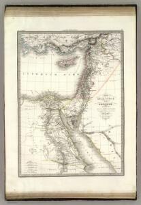
Egypt, Arabia Petraea, Nubia.
1 : 2854868 Johnston, Alexander Keith, 1804-1871
Egypt, Arabia Petraea, and Lower Nubia.
1 : 2854868 Johnston, W. & A.K.
Bez titulu: Historický Atlas

Egypt and Arabian Petraea.
1 : 3380000 Sharpe, J.
Aegypti Recentior Descriptio: Aegyptis & Turcis Elchibith; Arabibus Mesre & Misri, Hebraeis Mitsraim. [Karte], in: Novus atlas absolutissimus, Bd. 6, S. 165.
1 Karte aus Atlas Janssonius Offizin
Carte physique & politique de la Syrie, pour servir à l'histoire des conquêtes du général Bonaparte en Orient
faite au Kaire en l'an 8, par Charles Paultre [...] dessiné par Lapie [...] ; gravé par Blondeau [...] ; l'écriture gravée par L. Aubert [...] A Paris [etc.] : chez Lapie [...] ; Picquet [...] [etc.]
Aegyptus et Palaestina
Schul-Atlas der alten Welt bei Justus Perthes
Composite: Egypte geographique.
1 : 1000000 Jacotin, Pierre, 1765-1827
Nova Ægypti tabula
1 : 3000000 Annotatie: Kaart van Noord-Egypte en de Rode Zee; Origineel is Blad 203 in atlas factice; Annotatie geografische gegevens: Vertikale schaalstok op kaart: 25 Milliaria Germanica (=6,3 cm); Oost boven [Amstelaedami] : [Labore & Sumptibus Ioannis Blaeu]
Egypt, Arabia, Palestine.
1 : 1940000 Robert Laurie & James Whittle
Syrien u. Aegypten
[Allgemeiner Atlas über alle Theile der Erde in 29 Blättern] Ziegler, Jakob Melchior Top. Anstalt v. J. Wurster u. Comp.
Übersichtskarte Konya-Kairo
1 : 1000000 Gen St d H Abt f Kr Kart u Verm Wes
Aegypten oder Misr
1 : 3710000 Egypt Schlieben Gleditsch
Das alte Aegypten
1 : 3871000 Egypt Schlieben Gleditsch