Maps of Africa
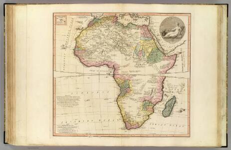
Africa.
1 : 17000000 Faden, William, 1750?-1836
Africa.
1 : 48000000 Cummings, J. A. (Jacob Abbot)
Africa
A new general atlas of modern geography, consisting of a complete collection of maps of the four quarters of the globe Wyld, James James Wyld
Africa [...] [Karte], in: Atlas, sive, Cosmographicae meditationes de fabrica mundi et fabricati figura, S. 68.
1 Karte aus Atlas Mercator, Gerhard
[3][3]Totius Africae accuratissima tabula, uit: Atlas sive Descriptio terrarum orbis
Annotatie: Gedigitaliseerde versie. Amsterdam. Heiloo : Picturae (vervaardiger), 2015. tiff-bestand. Gedigitaliseerd: 07-01-2015; Origineel: Universiteitsbibliotheek Vrije Universiteit (XL.05127.-) ; Netherlands; Titelpagina ontbreekt Wit, Frederik de Amsterdam : Frederick de Wit

Afrique physique dressée et dessinée par J.V. Barbier
1 : 20000000 Nancy : A. Barbier
Afrique pour la petite géographie méthodique et le manuel de géographie Achille Meissas et Michelot
1 : 40000000 Meissas, Achille; Hachette. Firme [Paris?] : A la librairie de L. Hachette
Africa.
1 : 65000000 Adams, Daniel

Africa.
1 : 38000000 Reichard, C. G.
Africa [Karte], in: Gerardi Mercatoris Atlas, sive, Cosmographicae meditationes de fabrica mundi et fabricati figura, S. 67.
1 Karte aus Atlas Mercator, Gerhard Montanus, Petrus

Africa.
1 : 50000000 D.F. Robinson & Co.
Africa.
1 : 45000000 Huntington, Hezekiah, 1795-1865
Afrika
Allgemeiner Atlas [Walch, Johannes] im Verlag bei Johannes Walch
Stanford's library map of Africa / [Edward Stanford]
1 : 5977382 Annotatie: Oorspr. kaart op 4 bl; Oorspr. uitg.: London : Stanford, 1866; De kaart geeft de Britse heerschappij weer tijdens het hoogtepunt van de kolonisatie na de Eerste Wereldoorlog; Annotatie geografische gegevens: Schaalstokken op kaart: Eng: & Ital: Geo: miles; English stat: miles; French kilometres; French leagues; Portuguese leagues; Spanish miles, Turkish berri Edward Stanford 1827-1904 London : Stanford's Geographical Establishment
Africae nova Tabula. [Karte], in: Gerardi Mercatoris et I. Hondii Newer Atlas, oder, Grosses Weltbuch, Bd. 1, S. 33.
1 Karte aus Atlas Mercator, Gerhard und Hondius, Jodocus Jansson, Jan
Afrika.
1 : 30000000 Flemming, Carl
Afrika

AFRICÆ | nova descriptio
Auct: Guiljelmo Blaeuw [Amsterdam : Joan Blaeu]
Afrika.
1 : 30000000 Berghaus, Hermann
Africae nova Tabula. [Karte], in: Novus atlas absolutissimus, Bd. 6, S. 156.
1 Karte aus Atlas Janssonius Offizin
Composite: Africa.
1 : 8400000 Boulton, S.
CHARTE von AFRICA
1 : 30000000 Afrika
Charte von Africa
1 : 30000000 Afrika
L'AFRIQUE
1 : 21900000 Afrika Jaillot, Alexis-Hubert chez H. Iaillot
Africa
1 : 18050000 Afrika Weiland, Karl Ferdinand Verlag des Geograph. Instituts
Africa.
1 : 57000000 Adams, Daniel