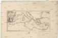
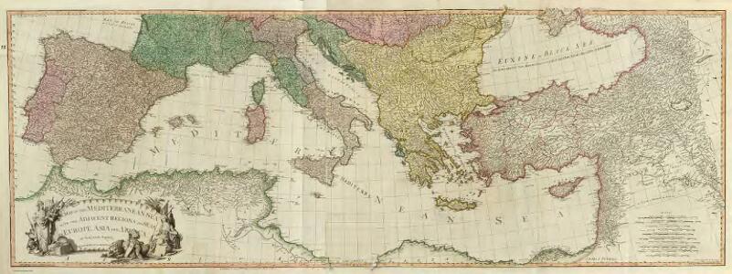
Maps of Mediterranean Sea
Composite: Mediterranean.
1 : 2850000 Faden, William, 1750?-1836
Mare internum cum populis adiacentibus a Pompeii ex Asia reditu usque ad bellum Actiacum.
1 : 12000000 Menke, Th.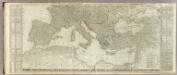
(Europe divided into its empires, kingdoms, states, republics, &c. Southern States)
1 : 4800000 Kitchin, Thomas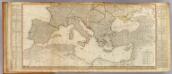
Europe (south)
1 : 4800000 Anville, Jean Baptiste Bourguignon d, 1697-1782; Kitchin, Thomas; Robert Laurie & James Whittle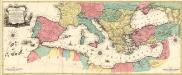
Carte Geographique representant la Mer Mediterranée ou la seconde Partie du Theatre de la Guerre entre les Russes et les Turcs
1 : 4400000 Mollova mapová sbírka Lotter, Tobias Conrad Lotter, Johann Jakob II.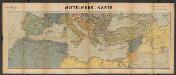
Metzer karten der Mittelmeer Raum
1 : 5950000 Metzer Verlagsanstalt Metz : Metzer Verlagsanstalt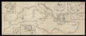
A correct chart of the Mediterranean sea from the coast of Portugal to the Levant
6 Carta nàutica. Conté: A plan of the city and Port of Civita-Vechia; The bay of Scanderoon; The bay of Tunis; A plan of the port of Neptune or Nation. Datació aproximada. Mount & Page William Mount & Thomas Page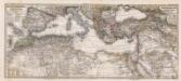
Composite: Mittellandische Meer, Nord-Afrika.
1 : 7500000 Petermann, A.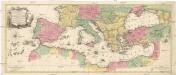
Carte geographique representant la Mer Mediterranée ou la seconde partie du théatre de la guerre entre les Russes et les Turcs
1 : 1000000 Evropa jižní Lotter, Tobias Conrad Tobie Conrad Lotter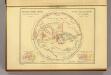
Geographie des Grecs Primitive.
Malte-Brun, Conrad, 1775-1826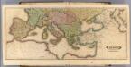
Europe (south)
1 : 6000000 Lizars, Daniel
Mittelländisches und Schwarzes Meer
Atlas der Hydrographie Berghaus, Hermann Justus Perthes
Das Mittellandische Meer Und Nord-Afrika.
1 : 7500000 Petermann, A.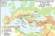
Südosteuropa im Frühmittelalter mit Jireček-Linie
Südosteuropa Sprachgeografie Zwick, J.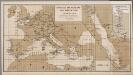
[Europa], uit: Routekaart van Nederland naar Ned. Indië en terug
1 : 8000000 Annotatie: Samengest. op uitnoodiging der Stoomvaart Maatschappij Nederland Groustra, J. Amsterdam : Seyffardt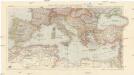
Karte der Länder des Mittelmeeres
1 : 5000000 Středozemní moře-oblast Freytag & Berndt
萬國通鑑:歐羅巴洲
美国传教士撰的向中国人介绍世界地理概况的著作,后有世界地图册1份,共13幅世界、大洲和区域地图,其中一幅题为《中國地圖》的清朝内地地图。 Sheffield, Devello Zelotos 謝衛樓 福州 : 美華書局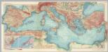
Mediterranean Sea. Pergamon World Atlas.
1 : 5000000 Polish Army Topography Service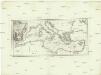
Karte des Mittellaendischen Meers
Středozemní moře Bonne, Rigobert Schraembl, Franz Anton F.A. Schraembl
Carte nouvelle de la mer Mediterranée : divisée en mer de Levant et de Ponant, subdivisés en leurs principales parties ou mers : avec les observations des Mrs. de l'Académie
1 : 4375000 Sanson, Nicolas, 1600-1667 chez Pierre Mortier
Mediterranean Sea.
1 : 8236800 Stanford, Edward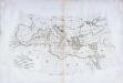
Carte des pays qu'occupe maintenant la mer Mediterranée
1 Karte : Kupferdruck ; 32 x 66 cm La Borde s.n.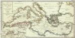
Karte des Mittellaendischen Meers enthaltend die europaische, afrikanische u. asiatische Küste
1 : 7000000 Středozemní moře-oblast Walch, Johann Joh. Walch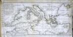
Charte vom mittellændischen Meer
1 Karte : Kupferdruck ; 23 x 49 cm Abel; Cotta im Verlag der J. G. Cotta'schen Buchhandlung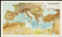
Mapa de la Conca Mediterrània: principals infrastructures de transport : regions europees riberenques de la Mediterrània
1 : 3500000 1 Mapa. Institut Cartogràfic de Catalunya ICC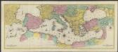
Carte géographique representant la Mer Méditerranée ou la seconde partie du Théatre de la guerre entre les russes et les turcs : c'est a dire les roiaumes, les étâts, les provinces et les diverses isles situées dans la dite Mer, avec la Mer Noire ou Pont Euxine et une partie de la province Georgie en Asia
1 : 4400000 par Tobie Conrad Lotter Augsbourg : Lotter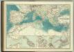
Mediterranean Basin.
1 : 6800000 Johnston, W. & A.K.
Mittelländisches Meer
1 : 8250000 Středozemní moře-oblast Elfert, P. Geogr. Anstalt von Wagner & Debes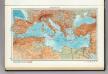
101. Mediterranean Sea. The World Atlas.
1 : 10000000 USSR (Union of Soviet Socialist Republics).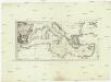
Karte des Mittellaendischen Meers
Středozemní moře-oblast Bonne, Rigobert Schraembl, Franz Anton F.A. Schraembl