Maps of United Kingdom

Bretagne Anglo Saxonne, 600 ans apres Jesus Christ.
1 : 4500000 Houze, Antoine Philippe
Angleterre, Irelande & Ecosse 1281 a 1400.
1 : 4500000 Houze, Antoine Philippe
Royaume Uni, Angleterre, Ecosse, et Irlande 1603 a 1839.
1 : 4500000 Houze, Antoine Philippe
Iles Britanniques ancienne, Germanie, de la Rhetie, du Norique, etc.
1 : 3800000 Picquet, C.
Iles Britanniques et Germanie Anciennes.
Levasseur, E.
Bretagne Anglo Saxonne, 800 ans apres J.C.
1 : 4500000 Houze, Antoine Philippe
Bretagne apres l'invasion des Saxons, 500 ans apres Jesus Christ.
1 : 4500000 Houze, Antoine Philippe
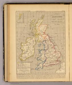
Angleterre, Ecosse, Irlande et Man en 1100.
1 : 4500000 Houze, Antoine Philippe
Soubor němých map pro gymnasia a odborné školy

Map of the British Isles.
1 : 3500000 Warner & Beers
British Isles.
1 : 4100000 Cornell, S. S. (Sarah S.)
Iles Britanniques, chemins de fer, canaux.
1 : 2700000 Garnier, F. A., 1803-1863
Iles Britanniques.
1 : 2900000 Garnier, F. A., 1803-1863
British Isles.
1 : 9300000 Fenner, Rest.
Gt. Britain, Ireland.
1 : 1800000 Robert Laurie & James Whittle
A compleat map of the British Isles.
1 : 2200000 Kitchin, Thomas
Bretagne Romaine sous Honorius, 400 ans apres Jesus Christ.
1 : 4500000 Houze, Antoine Philippe
Grossbritannien und Ireland
1 : 2200000 Irsko Weiland, Karl Ferdinand Maedel, Carl Jos. Geograph. Institut
Grossbritannien, Ireland.
1 : 3800000 Flemming, Carl
Grossbritanien und Irland
Irsko Sotzmann, Daniel Friedrich Kliewer, Heinrich

Britischen Inseln.
1 : 1800000 Kiepert, Heinrich, 1818-1899
British Islands.
1 : 5500000 Fitch, George W.
Gt. Britain, Ireland.
1 : 4800000 Mitchell, Samuel Augustus
Iles Britanniques.
1 : 2500000 Andriveau-Goujon, J.
British Isles.
1 : 5000000 Adams, Daniel
Industrial map of the British Islands
1 : 1200000 Shetlandy (Skotsko) Hughes, W. George Philip & Son

Grossbritannien.
1 : 24000000 Ziegler, J. M.