Maps of Levant Coast

Terre Sainte divisee en royaumes d'Israel et de Juda de 975 a 588.
1 : 2700000 Houze, Antoine Philippe
La Terre Sainte sous Salomon.
1 : 2800000 Houze, Antoine Philippe
Palestine.
1 : 840000 Hall, S. (Sidney)
Map of Syria

Palestine & Adjacent Countries.
1 : 1160000 Mitchell, Samuel Augustus
151. Palestine and Lebanon. The World Atlas.
1 : 1250000 USSR (Union of Soviet Socialist Republics).
Palestine & Adjacent Countries.
1 : 1150000 Tanner, Henry S.
Palestine.
1 : 714649 Johnston, W. & A.K.
La Terre Sainte partagee en 12 tribus.
1 : 2800000 Houze, Antoine Philippe
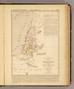
Karte von Phoenicien und Damask
1 : 700000 Damašek (Sýrie) Anville, Jean-Baptiste Bourguinon d' Schraembl, Franz Anton F.A. Schraembl
Karte von Phoenicien und Damask
1 : 700000 Damašek (Sýrie) Anville, Jean-Baptiste Bourguinon d' Schraembl, Franz Anton F.A. Schraembl
Syria Phoenice, Syria Palaestina, Provinciae ab aerae Christianae anno 70 usque ad Diocletiani tempus; Phoenice, Coelesyria, Decapolis, Iudaea Herediadarum tempore.
1 : 2000000 Menke, Th.
Palästina
Handatlas über alle Theile der Erde und über das Weltgebäude Stieler, Adolf Justus Perthes
Palästina
Hand-Atlas über alle Theile der Erde und über das Weltgebäude Stieler, Adolf Justus Perthes
Karte von Palestina
Izrael Marco Berra
Palastina. Das Libanon-Gebiet.
1 : 1200000 Petermann, A.
Palestine & Adjacent Countries.
1 : 1160000 Mitchell, Samuel Augustus
Palestine & Adjacent Countries.
1 : 1160000 Mitchell, Samuel Augustus
Palestine sous Constantin le Grand, 330 apres J.C.
1 : 2750000 Houze, Antoine Philippe
Palaestina.
1 : 1220000 Radefeld, Carl Christian Franz, 1788-1874
Purveyorships in the Reign of Solomon. (1826)
1 : 1800000 Tanner, Henry S.
Palestine.
1 : 60800000 Johnson, A.J.
Palestine.
1 : 60800000 Johnson, A.J.
Terra Sancta, sive Promessionis, olim Palestina / recens delineata, et in lucem edita per Nicolaum Visscher
1 : 900000 Annotatie geografische gegevens: West boven Visscher, Nicolaes (1618-1679) [Amsterdam : C.J. Visscher]
Carte de la Terre Promise
1 : 1600000 Izrael
KARTE von SYRIEN
1 : 450000 Sýrie Berghaus, Heinrich Karl Wilhelm Burckhardt, Johann Ludwig Justus Perthes
Karte von Syrien
1 : 450000 Sýrie Berghaus, Heinrich Karl Wilhelm Burckhardt Justus Perthes
Palästina und Libanon
Adolf Stieler's Handatlas über alle Theile der Erde und über das Weltgebäude Stieler, Adolf Justus Perthes