Maps of Morocco

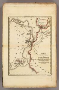
Conjecturale de l'Atlantide.
1 : 11000000 Vincent
West Africa.
1 : 15000000 Colton, G.W.
L'Afrique 1.
1 : 10000000 Brue, Adrien Hubert, 1786-1832
Archipelagus atlanticus cum suis insulis Canariis, Hesperidibus et Azoribus
1 : 1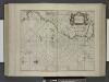
De cust van Barbaria, Gualata, Arguyn, en Geneheo, van Capo Verde.
from De zee-atlas ofte water-wereld : waer in vertoont werden alle de zee-kusten van het bekende des aerd-bodems : seer dienstigh voor alle heeren en kooplieden, als oock voor alle schippers en stuurlieden / by Pieter Goos.
Africa NW.
1 : 10000000 Andree, Richard; Times (London, England)
Partie occidentale de l'ancien continent depuis Lisbonne jusquà la Riviere de Sierra Leona, avec l'Isle Madere, les Isles Canaires, et celles du C. Verd
1 : 11500000
Carte d'une parte de l'Afrique
1 : 5860000 Afrika severozápadní Lapie, Pierre
Barbariae et Guineae maritimi à freto Gibraltar ad fluvium Gambiae cum Insulis Salfis Flandrisis et Canaricis
1 : 55000000
La Guinee 1.
1 : 9000000 Bonne, Rigobert, 1727-1794
De cust van Barbaria, Gualata, Arguyn, en Geneheo, van Capo S. Vincente tot Capo Verde
1 : 6000000 Annotatie: Uit: De lichtende columne, ofte zeespiegel ... - Amsterdam : Anthony Jacobsz., 1644 [Amsterdam : Anthony Jabobsz.]
[135][138] Barbariae et Guineae Maritimi ..., uit: Atlas sive Descriptio terrarum orbis
Annotatie: Gedigitaliseerde versie. Amsterdam. Heiloo : Picturae (vervaardiger), 2015. tiff-bestand. Gedigitaliseerd: 07-01-2015; Origineel: Universiteitsbibliotheek Vrije Universiteit (XL.05127.-) ; Netherlands; Titelpagina ontbreekt Wit, Frederik de Amsterdam : Frederick de Wit
A chart of the coast of Barbaria with the western, Canaria, & Cape de Verd, isles
1 : 6000000
Partie occidentale de l'Afrique
1 : 9600000 Afrika západní Bonne, Rigobert André
Pascaart, Waer in men claarlyck zien can, alle havens rivieren droogten, gelegen tußchen C.S. Vincent en C. Verde [...] [Karte], in: Novus atlas absolutissimus, Bd. 9, S. 239.
1 Karte aus Atlas Janssonius Offizin
Pascaart, Waer in men claarlyck zien can, alle havens rivieren droogten, gelegen tußchen C.S. Vincent en C. Verde [...] [Karte], in: Het vijfde Deel Des Grooten Atlas : Vervatende De Water-Weereld, S. 182.
1 Karte aus Atlas Jansson, Jan Jansson, Jan
Karte von der westlichen kuste von Africa : von der strasse bey Gibraltar bis zu dem XI grade norderbreite ...wahrnehmungen entworfen
1 : 1
A chart of the western coast of Africa, from the Straits of Gibraltar to eleven degrees of north latitude, including the Canary & Cape Verd Islands
1 : 13000000
Barbariæ et Guineæ maritimi à freto Gibraltar ad fluvium Gambiæ
1 Karte : Kupferdruck ; 47 x 56 cm Renard apud L. Renard
de Vlaamsche en Canarische Eylanden [Karte], in: De Nieuwe Groote Vermeerderde Zee-Atlas ofte Water-Werelt, S. 55.
1 Karte aus Atlas Doncker, Hendrick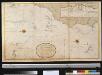
Generaale kaart van de kust van Barbarija van Portugaal tot Cabo Verde als ook de Carnarisse, Vlaamse en Zoute Eijl.
Atlantic Ocean Gerard van Keulen
De cust van Barbaria, Gualata, Arguyn en Geneheo van Capo S. Vincent tot Capo Verde
1 Karte : Kupferdruck ; 42 x 53 cm Doncker bÿ Hendrick Doncker boecverkoper en graadboog-maker inde Nieuwe-brug-steech
Untitled

De cust van Barbaria, Gualata, Arguyn en Geneheo van Capo S Vincente tot Capo Verde
1 : 6000000
Paskaart van de cust van Portugal, Barbaria en Genehoa, beginnende van d'Barlenges tot aan C. Verde met al zyn Diepte en Drooghte dus ver Naaukeurig opgesocht door Ervaren Stuurlieden
1 : 5200000
167-168. Africa, West. The World Atlas.
1 : 7500000 USSR (Union of Soviet Socialist Republics).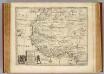
Negroland, adjacent countries.
1 : 10000000 Bowen, Emanuel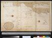
Nieuwe afteekening van de Spaanse Zee van het Canaal tot Cabo Verde
Atlantic Ocean Gerard van Keulen