Maps of Piedmont
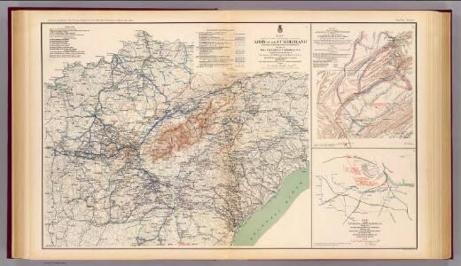
Army of the Cumberland campaigns.
1 : 2200000 United States. War Department
Campaigns in which the Army Of The Cumberland Took part during the War of the Rebellion.
1 : 1267200 Ruger, Edward
A map of Virginia, North and South Carolina, Georgia, Maryland with part of New Jersey &c.
from Parts Printed for R. (Richard) Baldwin in Pater Noster Row: [London] -- Bookseller,
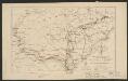
Carte des Etats-unis : provinces méridionales.
from Parts
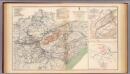
Army of the Cumberland.
1 : 7800000 National Tribune Co.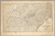
Military map showing the marches of the United States Forces 1863-1865.
1 : 1267200 United States. Army. Military Division of the Mississippi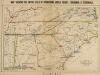
Map, shewing the Entire Field of Operations under Grant, Sherman & Thomas
Map, shewing the Entire Field of Operations under Grant, Sherman & Thomas. Published in London by Bacon & Co., this image of a Map Shewing the Entire Field of Operations, Under Grant, Sherman & Thomas details the Deep South Confederate States, principally of Tennessee, North Carolina, South Carolina, Georgia and Alabama, as well Virginia and the Union state of Kentucky. These areas witnessed the Union Army push in the last year and a half of the war, under the leadership of General Ulysses S. Grant. General George H. Thomas predominately fought in the western theatre of the conflict, while General William T. Sherman was responsible for the Army’s ultimately devastating march through the Southern states in 1864 and 1865. His marches through Georgia and the Carolinas, which crippled the home–front, remain a vital part of Civil War military history and Southern memory of the conflict. Bacon & Co.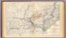
Military map, W.T. Sherman.
1 : 2200000 United States. War Department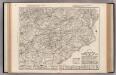
Auto Trail Map. Indiana, Ohio, Virginia, North Carolina, South Carolina, Georgia.
1 : 1893000 Rand McNally and Company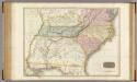
United States of America, southern part.
1 : 2200000 Pinkerton, John, 1758-1826
Shell Sectional Map No. 4 - East Central States.
1 : 1710720 Shell Oil Company
Carte des Provines Meridionales des Etats-Unis.
1 : 2400000 Marshall, John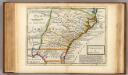
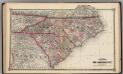
Carolina.
1 : 5500000 Moll, Herman, d. 1732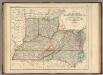
States Of Delaware, Maryland, Virginia (with the District of Columbia) North Carolina, Ohio, Kentucky, Tennessee, And Indiana.
1 : 3453120 Rogers, Henry Darwin
Nouvelle carte de la Caroline / par R. Morden.; L'Amerique angloise, ou Description des isles et terres du roi d'Angleterre, dans l'Amérique. Avec de nouvelles cartes de chaque isle & terres. Traduit de l'anglois.
from L'Amerique angloise, ou Description des isles et terres du roi d'Angleterre, dans l'Amérique. Avec de nouvelles cartes de chaque isle & terres. Traduit de l'anglois. Blome, Richard,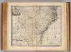
N. & S. Carolina, Georgia &c.
1 : 2900000 Bowen, Emanuel
The State of Tennessee.
from Carey's general atlas, improved and enlarged : being a collection of maps of the world and quarters, their principal empires, kingdoms, &c.
Frank Leslie's war maps
Leslie, Frank
Virginiae partis australis, et Floridae partis orientalis, interjacentiumq[ue] regionum, nova descriptio.
from John H. Levine Collection Meurs, Jacob van; Montanus, Arnoldus,
Virginiae partis australis, et Floridae partis orientalis, interjacentiumq[ue] regionum nova descriptio.
from Parts J. and C. Blaeu: [Amsterdam]; Blaeu, Joan; Blaeu, Willem Janszoon,
Virginiae partis australis et Floridae partis orientalis interjacentimq[ue] regionum, nova descriptio.
from Charts and maps Ioannem Ianssonium?: [Amstelodami?]; Jansson, Jan,
Virginiae partis australis, et Floridae partis orientalis, interjacentiumq[ue] regionum nova descriptio.
from Parts J. and C. Blaeu: [Amsterdam]; Blaeu, Joan; Blaeu, Willem Janszoon,
Virginiae partis australis, et Floridae partis orientalis, interjacentiumq[ue] regionum nova descriptio.
from John H. Levine Collection J. and C. Blaeu: [Amsterdam]; Blaeu, Joan; Blaeu, Willem Janszoon,
Virginiae partis australis, et Floridae partis orientalis, interjacentiumq[ue] regionum nova descriptio.
from Charts and maps J. and C. Blaeu: [Amsterdam]; Blaeu, Joan; Blaeu, Willem Janszoon,
Virginiae partis australis, et Floridae partis orientalis, interjacentiumq[ue] regionum nova descriptio.
from Parts J. and C. Blaeu: [Amsterdam]; Blaeu, Joan; Blaeu, Willem Janszoon,
County map of Kentucky and Tennessee.
from Mitchell's new general atlas, containing maps of the various countries of the world, plans of cities, etc., embraced in fifty-three quarto maps., forming a series of eighty four maps and plans, together with valuable statistical tables.
Maryland, Virginia, North Carolina, and South Carolina.
1 : 3651000 Fisher, Richard Swainson
Map showing route of marches of the army of Genl. W.T. Sherman, from Atlanta, Ga. to Goldsboro, N.C. : to accompany the report of operations from Savannah, Ga. to Goldsboro, N.C
1 : 1950000 United States. Army. Corps of Engineers Lith. of P.S. Duval & Son