Maps of Denmark
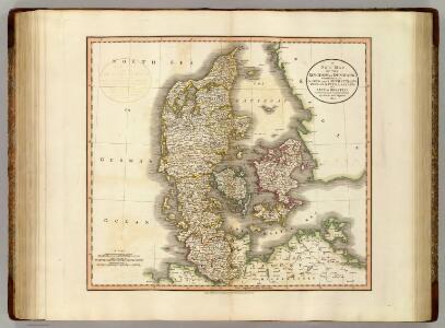
Denmark.
1 : 1100000 Cary, John, ca. 1754-1835
Daenemarck.
Dánsko Güssefeld, Franz L. Mollo, Tranquillo Tranquillo Mollo
Daenemarck
1 : 1260000 Bornholm (Dánsko) Mollo, Tranquillo Tranquillo Mollo
Daenemarck
1 : 1245000 Dánsko Tranquillo Mollo
Daenemarck.
Dánsko Güssefeld, Franz L. Mollo, Tranquillo Tranquillo Mollo
Denmark, Iceland, Feroe Islands.
1 : 960000 Thomson, John
Daniae Regnum [Karte], in: Gerardi Mercatoris Atlas, sive, Cosmographicae meditationes de fabrica mundi et fabricati figura, S. 140.
1 Karte aus Atlas Mercator, Gerhard Montanus, Petrus
Daniae Regnum [Karte], in: Atlas, sive, Cosmographicae meditationes de fabrica mundi et fabricati figura, S. 135.
1 Karte aus Atlas Mercator, Gerhard
[Daenemark mit Holstein und Lauenburg; auch Island und Fär-Öer]
Schul-Atlas über alle Theile der Erde nach dem neuesten Zustande, und über das Weltgebäude Stieler, Adolf bei Justus Perthes
Daenemark
E. von Sydow's Schul-Atlas in sechs und dreissig Karten Sydow, Emil von bei Justus Perthes
Daenemark mit Holstein und Lauenburg auch südlicher Theil von Schweden
1 : 3200000 Dánsko
Daniae Regnum [Karte], in: Gerardi Mercatoris et I. Hondii Newer Atlas, oder, Grosses Weltbuch, Bd. 1, S. 103.
1 Karte aus Atlas Mercator, Gerhard und Hondius, Jodocus Jansson, Jan
Daenemark
Allgemeiner Atlas [Walch, Johannes] im Verlag bei Johannes Walch
Regni Daniae Novißima et Accuratißima Tabula
1 : 1100000 Mollova mapová sbírka Visscher, Nicolaes Visscher, Nicolaus
Daenemark mit Schleswig, Holstein und Lauenburg auch Südl. Theil v. Schweden
Hand-Atlas über alle Theile der Erde nach dem neuesten Zustande und über das Weltgebäude Stieler, Adolf bei Justus Perthes
[Daenemark mit Schleswig, Holstein und Lauenburg auch Südl. Theil v. Schweden]
Hand-Atlas über alle Theile der Erde nach dem neuesten Zustande und über das Weltgebäude Stieler, Adolf bei Justus Perthes
[Königreich Daenemark]
Neuester Schul-Atlas Walch, Johann im Verlag bei Joh. Walch

Denmark, Sleswig, Holstein.
1 : 823680 Stanford, Edward
Dania regnum in quo sunt ducatus Holsatia et Slesvicum insulae Danicae et provinciae Iutia Scania Blekingia et Hallandia
1 : 1100000 Dánsko Danckerts, Justus per I. Danckers
Denmark with Northwest portion of the German Empire
1 : 1332000 Johnston, W. & A.K.
Pas-Caarte van't Schager-Rack, De Sondt en de Belt. [Karte], in: De Nieuwe Groote Vermeerderde Zee-Atlas ofte Water-Werelt, S. 21.
1 Karte aus Atlas Doncker, Hendrick
Denmark with Northwest portion of the German Empire
1 : 1332000 Johnston, Alexander Keith
Danemark, Schleswig, Holstein u. Lauenburg, Nebst Den Danischen Colonie'n.
1 : 1500000 Petermann, A.
Denmark with Northwest portion of the German Empire
1 : 1332000 Johnston, Alexander Keith
Das Königreich Daenemark nebst seinen Nebenlaendern in Europa
1 : 1100000 entworfen und gezeichnet von C.F. Weiland Weimar : Verlag des Geographischen Instituts
Atlas für Handel und Industrie: Für Kaufleute, Fabrikante u. Gewerbetreibende, Handlungs- u. Gewerbe-Schulen
Dania Regnum [Karte], in: Theatrum orbis terrarum, sive, Atlas novus, Bd. 1, S. 47.
1 Karte aus Atlas Blaeu, Joan Blaeu, Willem Janszoon
Le royaume de Danemark
1 : 1200000 Dánsko Sanson, Guillaume Cordier, Louis chez H. Iaillot
Das Königreich Daenemark
1 : 1090000 Dánsko Weiland, Karl Ferdinand Geographischen Institut