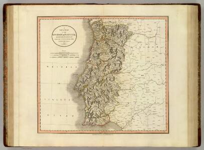
Maps of Portugal
Portugal.
1 : 1400000 Cary, John, ca. 1754-1835
Novissima regnorum Portugalliæ et Algarbiæ descriptio
1 Karte : Kupferdruck ; 41 x 52 cm Danckerts; Ottens; Ottens R. et I. Ottens
Novissima regnorum Portugalliæ et Algarbiæ descriptio
1 Karte : Kupferdruck ; 41 x 52 cm Danckerts I. Danckerts
Les estats de la couronne de Portugal en Espagne
1 Karte : Kupferdruck ; 41 x 43 cm Sanson; Somer chez l'autheur
Novissima regnorum Portugalliæ et Algarbiæ descriptio
1 Karte : Kupferdruck ; 57 x 47 cm Wit ex officina J. Cóvens et C. Mortier
Novissima regnorum Portugalliæ et Algarbiæ descriptio
1 Karte : Kupferdruck ; 57 x 47 cm Wit ex officina Frederici De Witt
[7][7]Novissima regnorum Portugalliae et Algarbiae descriptio, uit: Atlas sive Descriptio terrarum orbis
Annotatie: Gedigitaliseerde versie. Amsterdam. Heiloo : Picturae (vervaardiger), 2015. tiff-bestand. Gedigitaliseerd: 07-01-2015; Origineel: Universiteitsbibliotheek Vrije Universiteit (XL.05127.-) ; Netherlands; Titelpagina ontbreekt Wit, Frederik de Amsterdam : Frederick de Wit
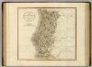
Portugal.
1 : 2600000 Moll, Herman, d. 1732
Portugallia et Algarbia, quæ olim Lusitania novissima descriptio
1 Karte : Kupferdruck ; 41 x 52 cm Danckerts in de Calverstraet inde Danckers
Regna Portugalliæ et Algarbiæ
1 Karte : Kupferdruck ; 56 x 47 cm Lotter; Lotter Tobias Konrad Lotter
Nova regni Portugalliæ et Algarbiæ descriptio
1 Karte : Kupferdruck ; 49 x 58 cm La Feuille; Ottens; Ottens apud Jaco.m de la Feuille
Portugalliae et Algarbiae Regna
1 : 1500000 per Nicolaum Visscher [Amsterdam] : nunc apud Petrum Schenk Junior
Portugalliae et Algarbiae Regna / per Nicolaum Visscher
1 : 1500000 Annotatie: Cum privilegio ordinum Hollandiæ et West-Frisiæ; Origineel is Blad 6 in atlas factice; Annotatie geografische gegevens: Met 3 schaalstokken; Legenda Nicolaes Jansz. Visscher jr. 1649-1702 [Amsterdam : Nicolaes Visscher]
Portugallia et Algarbia quae olim Lusitania. [Karte], in: Le théâtre du monde, ou, Nouvel atlas contenant les chartes et descriptions de tous les païs de la terre, Bd. 2, S. 219.
1 Karte aus Atlas Blaeu, Willem Janszoon und Blaeu, Joan Blaeu, Willem Janszoon
Portugalliæ et Algarbiæ regna
1 Karte : Kupferdruck ; 45 x 55 cm Visscher Nicolaes Visscher
Regnorum Portugalliæ et Algarbiæ tabula, tam in suas sacras, quam profanas ditiones distincta
1 Karte : Kupferdruck ; 58 x 48 cm Allard; Elliger; Gouwen apud I. Cóvens et C. Mortier
Regnum Portugalliæ
1 Karte : Kupferdruck ; 58 x 45 cm Homann Homännische Erben
Portugallia et Algarbia quae olim Lusitania. [Karte], in: Novus Atlas, das ist, Weltbeschreibung, Bd. 2, S. 228.
1 Karte aus Atlas Blaeu, Joan Blaeu, Willem Janszoon

Portugalliæ et Algarbiæ regna
1 Karte : Kupferdruck ; 48 x 56 cm Seutter Matthäus Seutter
Portugalliæ et Algarbiæ cum finitimis Hispanniæ regnis
1 Karte : Kupferdruck ; 48 x 54 cm Homann Johann Baptist Homann
PORTVGALLIA | et | ALGARBIA | quæ olim | LVSITANIA
Auctore | Vernando Alvero Secco. Amsterdami | Apud Guiljelmum et Joannem Blaeuw
Portugallia et Algarbia quae olim Lusitania [Karte], in: Novus atlas absolutissimus, Bd. 6, S. 37.
1 Karte aus Atlas Janssonius Offizin
Portugallia et Algarbia quae olim Lusitania [Karte], in: Gerardi Mercatoris et I. Hondii Newer Atlas, oder, Grosses Weltbuch, Bd. 2, S. 192.
1 Karte aus Atlas Mercator, Gerhard und Hondius, Jodocus Jansson, Jan
Corona Portugalliæ et Algarbiæ
1 Karte : Kupferdruck ; 58 x 49 cm Schenk Pieter Schenk
Portugallia et Algarbia quae olim Lusitania. [Karte], in: Theatrum orbis terrarum, sive, Atlas novus, Bd. 2, S. 226.
1 Karte aus Atlas Blaeu, Joan Blaeu, Willem Janszoon
Portvgallia
1 Karte : Kupferdruck ; 39 x 32 cm Weigel; Secco; Vasconcellos; Nonius Christoph Weigel
Portugall.
from A new systeme of the mathematicks: containing I. Arithmetick, as well natural and decimal, as in species, or the principles of algebra. II. Practical geometry, together with the first six books of Euclid's Elements, as also the eleventh and twelfth, symbo
Royaume de Portugal
1 Karte : Kupferdruck ; 53 x 41 cm Duval; Michu chez l'autheur en l'isle du Palais sur le quay de l'Orloge proche le coin de la ruë de Harlay