Maps of Florida

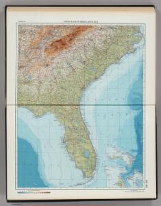
203-204. United States of America, South East. The World Atlas.
1 : 2500000 USSR (Union of Soviet Socialist Republics).
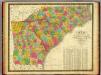
N. & S. Carolina.
1 : 6300000 Grigg, John
United States.
1 : 3380000 Sharpe, J.
A general map of the southern British colonies, in America comprehending North and South Carolina, Georgia, East and West Florida, with the neighbouring Indian countries : from the modern surveys of Engineer de Brahm, Capt. Collet, Mouzon & others
1 : 3000000 Romans, Bernard Robert Sayer & John Bennett (Firm)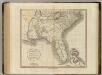
Carolinas, Georgia, Floridas, Bahamas.
1 : 3300000 Cary, John, ca. 1754-1835
A GENERAL MAP OF THE SOUTHERN BRITISH COLONIES IN AMERICA
1 : 3000000 Bahamy (souostroví) Romans, Bernard Collet, John Abraham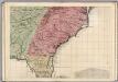
A Map of the British Empire in America. (Sheet 10).
1 : 2000000 Popple, Henry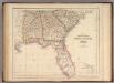
States Of South Carolina, Georgia, Alabama, And Florida.
1 : 3453120 Rogers, Henry Darwin
Florida, Georgia, and South Carolina.
1 : 3000000 Lloyd, H.H.
Florida, Georgia, and South Carolina.
1 : 3000000 Walling, H. F.
Alabama, Georgia, Sud Carolina und Florida.
1 : 3400000 Lange, Henry, 1821-1893.
Shell Sectional Map No. 5 - Southeastern States.
1 : 1710720 Shell Oil Company

Georgia, Alabama, and Florida.
1 : 3623775 Fisher, Richard Swainson
Virginiae Item et Floridae Americae Provinciarum, nova Descriptio. [Karte], in: Gerardi Mercatoris Atlas, sive, Cosmographicae meditationes de fabrica mundi et fabricati figura, S. 553.
1 Karte aus Atlas Mercator, Gerhard Montanus, Petrus
Florida.
from Supplement to the New York observer.
N. & S. Carolina, Georgia &c.
1 : 2900000 Bowen, Emanuel
Carolina.
1 : 5500000 Moll, Herman, d. 1732
Carte general de la Caroline: dresse sur les memoires le plus nouveaux
1 : 1300000 Published in N. Sanson's "Atlas Nouveau Contenant Toutes Les Parties du Monde", Paris, 1696, based on the 1685 Thornton-Morden-Lea map. Relief shown pictorially. Depths shown by soundings. Prime meridian: [Cadiz]. Includes inset [scale ca. 1:203,000] of the Ashley and Cooper Rivers, including Charles Town. Sanson, Nicolas, 1600-1667.;Mortier, Pierre. chez Pierre Mortier
North Carolina, South Carolina, Georgia.
1 : 1788000 Finley, Anthony
Georgia & Florida.
1 : 2920000 Black, Adam & Charles
North Carolina, South Carolina, Georgia and Eastern Tenessee

North Carolina, South Carolina, Georgia and Eastern Tennessee
Map of North and South Carolina, and Georgia.
1 : 1800000 Mitchell, Samuel Augustus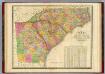
Map Of North and South Carolina And Georgia.
1 : 1750000 Finley, Anthony
VIRGINIÆ | partis australis, | et FLORIDÆ partis | orientalis, interjacentiumque regionum | NOVA DESCRIPTIO.
[Amsterdam : Joan Blaeu]
North Carolina, South Carolina, Georgia and eastern Tennessee
1 : 2000000 Charleston (Jižní Karolína) Bumstead, Albert H. National Geographic Society
Virginiae partis australis, et Floridae partis orientalis, interjacentiumque regionum Nova Descriptio. [Karte], in: Novus atlas absolutissimus, Bd. 6, S. 210.
1 Karte aus Atlas Janssonius Offizin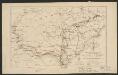
Map showing route of marches of the army of Genl. W.T. Sherman, from Atlanta, Ga. to Goldsboro, N.C. : to accompany the report of operations from Savannah, Ga. to Goldsboro, N.C
1 : 1950000 United States. Army. Corps of Engineers Lith. of P.S. Duval & Son