Maps of Belgium

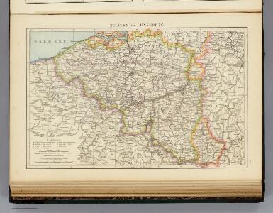
Belgien, Luxemburg.
1 : 1000000 Andree, Richard
Netherlands.
1 : 1650000 Bowen, Frances
Provinces des Pais Bas
1 : 800000 Mollova mapová sbírka Fer, Nicolas de Starckman, P. Fer, Nicolas de
Seat of war Netherlands.
1 : 630000 Robert Laurie & James Whittle
Nieuwe kaart van de tien verdeelde Nederlanden
1 : 1700000 [S.l.] : [s.n.]
Belgique. Carte oro-hydrographique 1:500 000 = België oro-hydrografische kaart 1:500 000
1 : 500000 Ghellinck, A . de Turnhout : Brepols
Netherlands.
1 : 1670000 Seaman, James V.
Pay-Bas Autrichiens.
1 : 1020000 Clouet, J. B. L. (Jean-Baptiste Louis), b. 1730
(Les Pays-Bas autrichiens & francois)
1 : 5200000 Bruyset, Jean-Marie; Schneider, J. H.
Der Burgundische Kreis oder die Oestreichischen Niederlande
1 : 1370000 Burgundsko (Francie)
Carte des Pais Bas Catholiqves ou des X Provinces de l'Allemagne Inferieure etc. dessinée au juste selon les exactes observations Astronimiques et Operations Geometriques des Mess. Cassini. Snelius. Muschenbrok etc. dresée par Sr. Tobias Maier. Mathematicien
1 : 725000 Mollova mapová sbírka Mayer, Tobias Homann, Johann Baptista - dědici
Pays Bas meridionale.
1 : 970000 Janvier, Jean
Circvlvs Bvrgundicvs
1 : 2700000 Mollova mapová sbírka Franz, Johann Michael Homann, Johann Baptista - dědici
Austrian French and Dutch Netherlands.
1 : 1030000 Carey, Mathew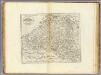
Austrian French and Dutch Netherlands.
1 : 1020000 Carey, Mathew
Austrian French and Dutch Netherlands.
1 : 1020000 Carey, Mathew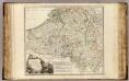
Pays-Bas Catholiques, Luxembourg.
1 : 630000 Robert de Vaugondy, Gilles, 1688-1766
Belgium Regium Accuratissime Divisum. &c: Ad Usum Serenissimi Burgundiae Ducis. Authore G. de l'Isle, Geographe
1 : 710000 Mollova mapová sbírka Delisle, Guillaume Luchtenburg, Johannes van Covens, Johannes I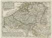
Flanders or the Austrian Netherlands
1 : 1400000 Mollova mapová sbírka Moll, Herman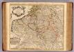
Pays Bas Catholoques.
1 : 700000 L'Isle, Guillaume de, 1675-1726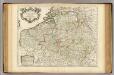
Pays Bas Catholoques.
1 : 700000 L'Isle, Guillaume de, 1675-1726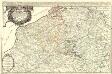
Les Provinces des Pays Bas Catholiques, restées pour la pluspart sons l'obeißance du Roy d'Espagne se'les Duchés de Brabant, Limbourg, Luxembourg, et partie de Gueldre, Les Comtes de Flandre, Artois, Haynaut, Namur, Le Marquisat du Empire, Anvers, et la Seugneurie de Malines, ou sont exactement distiquées toutes les Conquestes de Sa Majeste Tres Chrestienne. reünies a la Couronne de France, dans les Provinces de Flandre, Artois, Haynaut, Namur, et Luxembourg, comme außy tout ce que poßedent les Estats Generaux des Provinces - vnies dans la Flandre, le Brabant, et le Limbourg, ou sont encor l'Archevesche de cambray en Protection du Roy d'Espagne, et l'Evesche de Lyege possedé par l'Eslecteur de Cologne. Dressé sur les Memoires les plus recents
1 : 550000 Mollova mapová sbírka Sanson, Guillaume Jaillot, Alexis Hubert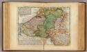
Flanders or the Austrian Netherlands.
1 : 1400000 Moll, Herman, d. 1732
Belgium Catholicum seu Decem Provinciae Germaniae Inferioris...

Netherlands.
1 : 1350000 Arrowsmith, Aaron; Lewis, Samuel
Netherlands.
1 : 1350000 Arrowsmith, Aaron; Lewis, Samuel
The theatre of the present war in the Netherlands : being an improvement of a large map of the Low Countries by Mr. La Rouge : with the addition of the adjacent parts of England, Germany and the United Provinces
1 : 350000 Annotatie: Met plaatsnamenregister (met coördinaten en afstanden t.o.v. Londen, Parijs en Den Haag) London : printed for R. Wilkinson ... and Bowles & Carver
Circvlvs Bvrgvndicvs
1 : 732700 Belgie Mayer, Tobias Cassini de Thury Homannianis heredib.
Belgivm catholicvm seu Decem provinciae Germaniae inferioris
1 : 732700 Belgie Mayer, Tobias Cassini de Thury Homannianis heredib.