Maps of Algeria
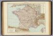
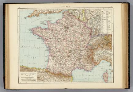
Frankreich.
1 : 3000000 Andree, Richard
The River Niger.
1 : 3400000 Arrowsmith, John
Algérie
1 : 3500000 Alžírsko Gouvernement général de l'Algérie, Service cartographique
Algérie
1 : 3500000 Alžírsko Gouvernement général de l'Algérie, Service cartographique
Afrika
1 : 7500000 Afrika severozápadní Domann, Bruno Justus Perthes
Région saharienne française
1 : 4000000 Niox, Gustave-Léon 1840-1921 Paris : Ch. Delagrave
Carte reduite de la Mer Mediterranée, 1
1 Blatt : 59 x 51 cm ; s.n.
Partie occidentale de la mer Méditerranée
1 Karte : Kupferdruck ; 49 x 55 cm Robert de Vaugondy Didier Robert de Vaugondy
Algérie
1 : 7000000 Alžírsko SCGGA
Carte des divisions administratives de l'Algérie
1 : 3200000 Calléja, N.; Algérie. Direction de l'agriculture et de la colonisation Alger : Imp. Jourdan
Algérie, Tunisie et Sahara central, pour servir particulièrement à l'intelligence des évenements actuels et notamment à suivre les deux explorations du colonel Flatters
1 : 5000000 Barbier, Joseph-Victor 1840-1898 Nancy : Albert Barbier
La mer Mediterranée vers l'occident
1 Karte : Kupferdruck ; 38 x 49 cm Duval P. Duval
[133][136] Occidentalior tractus Maris Mediterranei, uit: Atlas sive Descriptio terrarum orbis
Annotatie: Gedigitaliseerde versie. Amsterdam. Heiloo : Picturae (vervaardiger), 2015. tiff-bestand. Gedigitaliseerd: 07-01-2015; Origineel: Universiteitsbibliotheek Vrije Universiteit (XL.05127.-) ; Netherlands; Titelpagina ontbreekt Wit, Frederik de Amsterdam : Frederick de Wit
France.
from A new systeme of the mathematicks: containing I. Arithmetick, as well natural and decimal, as in species, or the principles of algebra. II. Practical geometry, together with the first six books of Euclid's Elements, as also the eleventh and twelfth, symbo
Ooster Deel der Middelandsche Zee [Karte] [Bona.] [Saragoßa.] [C. Carbonera] [Baya de Agde in Languedoq.] [Alcol] [P. Farina.] [Susa.] [Alzyra.] [8 Nebenkarten], in: De Nieuwe Groote Vermeerderde Zee-Atlas ofte Water-Werelt, S. 51.
1 Karte aus Atlas Doncker, Hendrick
Spain, or Celtiberia.
from A new sett of maps both of antient and present geography : wherein not only the latitude and longitude of many places are corrected according to the latest observations, but also the most remarkable differences of antient and present geography may be quickly discern'd by a bare inspection or comparing of correspondent maps, which seems to be the most natural and easy method to lead young students (for whose use the work is principally intended) unto a competent knowledge of the geographical science : together with a geographical treatise particularly adapted to the use and design of these maps / by Edward Wells, M.A. and student of Christ-Church, Oxon.
Western part of the mediterranean sea with the coasts of Spain France Italy Barbary
1 Blatt : 53 x 68 cm Sayer
France, Spain, and Portugal.
1 : 3650000 Johnson, A.J.
Carte generale de toute l'Europe, 4
1 Blatt : 56 x 48 cm J.M. Will
Pascaarte Van 't westlyckste deel vande Middelandsche-Zee [...] [Karte], in: Novus atlas absolutissimus, Bd. 9, S. 253.
1 Karte aus Atlas Janssonius Offizin
Carte de la Mer Méditerranée, 1
1 Blatt : 50 x 51 cm Froullé
萬國通鑑:歐羅巴洲耶穌後一千年
美国传教士撰的向中国人介绍世界地理概况的著作,后有世界地图册1份,共13幅世界、大洲和区域地图,其中一幅题为《中國地圖》的清朝内地地图。 Sheffield, Devello Zelotos 謝衛樓 福州 : 美華書局
Pascaarte Van't westlyckste deel vande Middelandsche-Zee [...] [Karte], in: Het vijfde Deel Des Grooten Atlas : Vervatende De Water-Weereld, S. 187.
1 Karte aus Atlas Jansson, Jan Jansson, Jan
Afrique occid.le franç.se
1 : 3000000 Afrika západní Meunier, Alexandre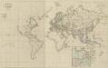
XI. Charte für die allgemeine Geschichte von der Selbstregierung Ludwig XIV. bis auf den österreichischen Erbfolgekrieg : d.i. von 1661 bis 1740 n. Christus
Entworfen von F.W. Benicken A. Falger gr. Weimar : im Verlage des L. Industrie-Comptoirs
La Mediterranée, 1
1 Blatt : 53 x 63 cm Le Rouge
Western Europe.
1 : 7303000 Fisher, Richard Swainson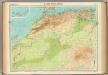
North-west Africa.
1 : 5000000 John Bartholomew and Son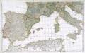
Prémière partie de la carte d'Europe contenant la France, l'Alemagne, l'Italie, l'Espagne & les isles britanniq.s, 2
1 Blatt : 53 x 85 cm s.n.