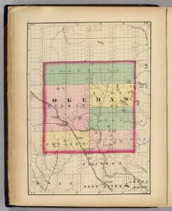
Maps of Ogemaw County

(Map of Ogemaw County, Michigan)
1 : 190080 Walling, H. F.
Sage Lake
1 : 24000
Ogemaw Springs
1 : 24000
Ogemaw Springs
1 : 24000
West Branch
1 : 24000
West Branch
1 : 24000
West Branch
1 : 24000
Selkirk
1 : 24000
Selkirk
1 : 24000
South Branch
1 : 24000
South Branch
1 : 24000
Damon
1 : 24000
Rose City
1 : 24000
Rose City
1 : 24000
Rose City
1 : 24000
Edwards
1 : 24000
Sterling NW
1 : 24000
Skidway Lake
1 : 24000
Prescott
1 : 24000
Houghton Lake
1 : 100000
Traverse City
1 : 250000
Traverse City
1 : 250000
Traverse City
1 : 250000
Traverse City
1 : 250000
Traverse City
1 : 250000
Traverse City
1 : 250000
Tawas City
1 : 100000
Tawas City
1 : 100000
Tawas City
1 : 100000