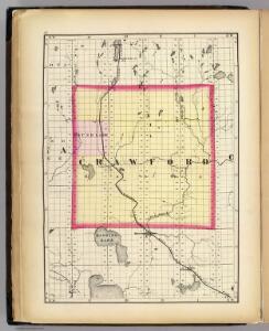
Maps of Michigan

Maps of Michigan

$title$

(Map of Crawford County, Michigan)

1 : 190080 Walling, H. F.
$title$

Grayling

1 : 62500
$title$

Eldorado

1 : 24000
$title$

Eldorado

1 : 24000
$title$

Pere Cheney

1 : 24000
$title$

Pere Cheney

1 : 24000
$title$

Pere Cheney

1 : 24000
$title$

Roscommon North

1 : 24000
$title$

Roscommon North

1 : 24000
$title$

Luzerne NW

1 : 24000
$title$

Luzerne NW

1 : 24000
$title$

Luzerne NW

1 : 24000
$title$

Grayling

1 : 24000
$title$

Wakeley Lake

1 : 24000
$title$

Wakeley Lake

1 : 24000
$title$

Grayling

1 : 24000
$title$

Cote Dame Marie

1 : 24000
$title$

Cote Dame Marie

1 : 24000
$title$

Cote Dame Marie

1 : 24000
$title$

Lake Margrethe

1 : 24000
$title$

Big Bradford Lake

1 : 24000
$title$

K P Lake

1 : 24000
$title$

K P Lake

1 : 24000
$title$

Lovells

1 : 24000
$title$

Lovells

1 : 24000
$title$

Lovells

1 : 24000
$title$

Frederic

1 : 24000
$title$

Grayling

1 : 100000
$title$

Grayling

1 : 100000
$title$

Fletcher

1 : 62500
© MapTiler © OpenStreetMap contributors
How does it work?
These instructions will show you how to find historical maps online.
Getting started
Type the place name in the search box to find the exact location. You can further adjust the search by zooming in and out.
Zoom
Zoom in and out with the buttons or use your mouse or touchpad natively.
Exact Area tool
Click here and draw a rectangle over the map to precisely define the search area.
Set filters
Narrow your search with advanced settings, such as Years (from/to), Fulltext, Publisher, etc.
Results
See the results of your search on the right side. You can scroll down to find more maps of this location.
?

Download OldMapsOnline Mobile