Maps of Egvekinot

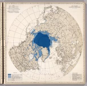
Ice Chart, Northern Hemisphere, November.
U.S. Navy
River Ice in Relation to Navigation, Opening Dates.
U.S. Navy
River Ice in Relation to Navigation, Closing Dates.
U.S. Navy
Ice Chart, Northern Hemisphere, December.
U.S. Navy
Ice Chart, Northern Hemisphere, June.
U.S. Navy
Ice Chart, Northern Hemisphere, July.
U.S. Navy
Comparative Size of Lakes and Islands of the world.
1 : 12500000 Colton, G.W.
5. Atlas des ganzen Erdkreises.
1 : 45000000 Reichard, C. G.
Frontispiece: North Pole Chart.
1 : 23500000 Johnston, Alexander Keith
Northern Regions, North Pole. Southern Regions, South Pole.
Colton, G.W.
(World, gnomonic proj. V. North Pole-45 N. Lat.)
1 : 5000000 Society for the Diffusion of Useful Knowledge (Great Britain)
Frontispiece: North Pole Chart.
1 : 23500000 Johnston, Alexander Keith
Gareloi Island
1 : 250000
Gareloi Island
1 : 250000
Gareloi Island
1 : 250000
Gareloi Island
1 : 250000
Gareloi Island
1 : 250000
Gareloi Island
1 : 250000
Gareloi Island
1 : 250000
Regions Polaires
Vivien St Martin, L.
World in Hemispheres.
1 : 72000000 Johnston, Alexander Keith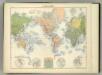
Planisphere.
1 : 82000000 Jouvet et Cie.
The World.
1 : 110000000 Hughes, William
Mappe -Monde en deux Hemispheres.
1 : 95000000 Vivien de St Martin, L.
Forest Trees, Useful Plants, and Minerals.
1 : 100000000 Johnson, A.J.
World on Mercator's Projection.
1 : 65000000 Asher & Adams
World, Moravia missions.
1 : 210000000 Peterson, Augusts
World Mercator's proj.
1 : 114000000 Darton, William
248-249. Arctic, Antarctic. The World Atlas.
1 : 20000000 USSR (Union of Soviet Socialist Republics).