Maps of Aragón

41-42. Spagna, Portogallo est.
1 : 1500000 Touring club italiano
Spanien oest.
1 : 2350000 Radefeld, Carl Christian Franz, 1788-1874
[Spanien oestliche Hälfte]
Grosser Hand-Atlas über alle Theile der Erde in 170 Karten Meyer, J. Verlag des Bibliographischen Instituts
Spain & Portugal - eastern section.
1 : 2000000 John Bartholomew and Son
Carte de la Peninsule Hispanique.
1 : 2750000 Vivien de St Martin, L.
Les estats de la couronne d'Arragon en Espagne ou sont l'Arragon royaume, le Catalogne princip.te
1 Karte : Kupferdruck ; 41 x 53 cm Sanson; Mariette; Somer chez Pierre Mariette rue St. Iacques a l'esperance
Mapa del domini lingüístic del català / Entitat Autònoma del Diari Oficial i de Publicacions, Institut Cartogràfic de Catalunya
1 Mapa, col. Entitat Autònoma del Diari Oficial i de Publicacions ; Institut Cartogràfic de Catalunya
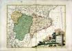
La Catalogna li regni di Aragona, ed Alta Navarra
1 Karte : Kupferdruck ; 28 x 38 cm Zatta presso Antonio Zatta

A new Military Map of Spain and Portugal compiled from The Nautical Surveys of Don Vincent Tofiño, the new Provincial maps of Don Tomas Lopez, the large map of the Ptrenees by Roussill, and various original documents
1 Mapa en 4 seccions dins d'un estoig. John Stockdale J. Stockdale
Mapa dels actuals dominis de la llengua catalana: ab indicació dels principals dialectes qui la formen y de les localitats estudiades lexicològicament per a la formació del Diccionari / F. de B. Moll dib.
1 : 800000 1 mapa b/n. Originàriament dins: Diccionari català, valencià, balear de A.M. Alcover i F. de B. Moll, vol.I. Palma, 1926. Datat entre 1921 i 1926 aproximadament. Moll, Francesc de Borja; Alcover, Antoni Maria
Espagne et Portugal. Flle. N.E.
1 : 1250000 Vivien St Martin, L.
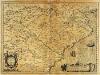
Arragonia et Catalonia [Karte], in: Gerardi Mercatoris Atlas, sive, Cosmographicae meditationes de fabrica mundi et fabricati figura, S. 192.
1 Karte aus Atlas Mercator, Gerhard Montanus, Petrus
Les royaumes d'Aragon et de Navarre, partie des deux Castilles et du royaume de Valence
1 Karte : Kupferdruck ; 44 x 56 cm Jaillot; Dezauche chez Dezauche géog. rue des Noyers près celle des Anglois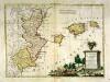
Li regni di Valenza et Murcia con l'isole Baleari, e Pitiuse
1 Karte : Kupferdruck ; 29 x 39 cm Zatta presso Antonio Zatta
[Spanien und Portugal, Blatt 2]
Adolf Stieler's Handatlas über alle Theile der Erde und über das Weltgebäude Stieler, Adolf Justus Perthes
[Spanien und Portugal in 4 Blättern, Blatt 2]
Handatlas über alle Theile der Erde und über das Weltgebäude Stieler, Adolf Justus Perthes
Spanische Halbinsel, Blatt 2.
1 : 1500000 Vogel, C.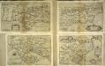
Aragonia et Catalonia
1 Karte : Kupferdruck ; 15 x 22 cm Lambert Andreae
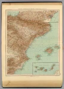
Spain = España : II
1 mapa. J. & C. Walker sculp. The Society for the Diffusion of Useful Knowledge; Charles Knight & Co
Carte De La Mer Mediterranee. II.
Roux, Joseph
Hispania Benedictina
1 : 2100000 Mollova mapová sbírka Carl, Rupert Homann, Johann Baptista - dědici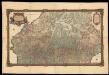
Carte generale des Monts Pyrénees, et partie des royaumes de France et d'Espagne / par le Sr. Roussel ; J.B. Delahaye scrip. ; A. Coquart fecit
1 : 270000 1 Mapa, col. Datació aproximada. Roussel ; Delahaye, J.B. ; Coquart, A. Dépôt des Fortifications
Exactissima et postomnes alias nunc demùm edita tabula continens perfectam descriptionem regnorum Arragoniæ et Navarræ, principatûs Cataloniæ
1 Karte : Kupferdruck ; 46 x 58 cm Ottens; Ottens R. et J. Ottens
[Spanien und Portugal in 4 Blättern]
Hand-Atlas über alle Theile der Erde nach dem neuesten Zustande und über das Weltgebäude Stieler, Adolf bei Justus Perthes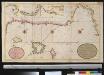
Afteekening van Valence Catalonie Langedocq en Provence tussen C. St. Martin en Toulon met de eijlanden Ivica Majorka en Minorca
Spain Gerard van Keulen
[Spanien und Portugal in 4 Blättern]
Hand-Atlas über alle Theile der Erde nach dem neuesten Zustande und über das Weltgebäude Stieler, Adolf bei Justus Perthes
[Spanien und Portugal in 4 Blättern]
Hand-Atlas über alle Theile der Erde und über das Weltgebäude Stieler, Adolf Justus Perthes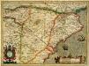
Arragonia et Catalonia
1 Karte : Kupferdruck ; 33 x 45 cm Mercator; Hondius Henricus Hondius
Arragonia [et] Catalonia
1 Karte : Kupferdruck ; 17 x 24 cm Mercator; Keere Cloppenburgh