Maps of Denmark
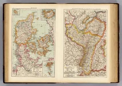
Denmark, Alsace-Lorraine, Palatinate.
1 : 1500000 Andree, Richard; Times (London, England)
Denmark, Sleswig, Holstein.
1 : 823680 Stanford, Edward
Dänemark mit Schleswig, Holstein
Dánsko
Denmark.
1 : 1500000 Colton, G.W.
Denmark.
1 : 1800000 Mitchell, Samuel Augustus
Denmark.
1 : 1800000 Mitchell, Samuel Augustus
Denmark.
1 : 1800000 Darton, William
Daenemark
Dánsko Berra, Marco bei Marco Berra
Daenemark
Allgemeiner Atlas [Walch, Johannes] im Verlag bei Johannes Walch
DANIA | REGNVM.
[Amsterdam : Joan Blaeu]
[64][64] Dania Regnum ..., uit: Atlas sive Descriptio terrarum orbis
Annotatie: Gedigitaliseerde versie. Amsterdam. Heiloo : Picturae (vervaardiger), 2015. tiff-bestand. Gedigitaliseerd: 07-01-2015; Origineel: Universiteitsbibliotheek Vrije Universiteit (XL.05127.-) ; Netherlands; Titelpagina ontbreekt Wit, Frederik de Amsterdam : Frederick de Wit
Regni Daniae Novißima et Accuratißima Tabula
1 : 1100000 Mollova mapová sbírka Visscher, Nicolaes Visscher, Nicolaus
Danemark.
1 : 2250000 Malte-Brun, Conrad, 1775-1826
Regni Daniæ : novissima et accuratissima tabula / per Nicolaum Visscher
1 : 1150000 Annotatie: Origineel is Blad 144 in atlas factice; Annotatie geografische gegevens: Met schaalstok: Milliaria Germanica communia Nicolaes Jansz. Visscher jr. 1649-1702 [Amsterdam] : [Nicolaes Visscher]
Denmark.
1 : 2400000 Bowen, Emanuel
[Königreich Daenemark]
Neuester Schul-Atlas Walch, Johann im Verlag bei Joh. Walch
Pas-Caarte van't Schager-Rack, De Sondt en de Belt. [Karte], in: De Nieuwe Groote Vermeerderde Zee-Atlas ofte Water-Werelt, S. 21.
1 Karte aus Atlas Doncker, Hendrick
Regni Daniae, Novißima et Accuratißima Tabula [Karte], in: Novus atlas absolutissimus, Bd. 1, S. 119.
1 Karte aus Atlas Janssonius Offizin
Das Königreich Daenemark
1 : 1090000 Dánsko Weiland, Karl Ferdinand Geographisches Institut
Post Karte von Daenemark nach Meilen
Dánsko Hallberg, von Santjohanser, N.
Daenemarck.
Dánsko Güssefeld, Franz L. Mollo, Tranquillo Tranquillo Mollo
Daenemarck
1 : 1260000 Bornholm (Dánsko) Mollo, Tranquillo Tranquillo Mollo
Daenemarck
1 : 1245000 Dánsko Tranquillo Mollo
Daenemarck.
Dánsko Güssefeld, Franz L. Mollo, Tranquillo Tranquillo Mollo
Dania Regnum [Karte], in: Le théâtre du monde, ou, Nouvel atlas contenant les chartes et descriptions de tous les païs de la terre, Bd. 1, S. 49.
1 Karte aus Atlas Blaeu, Willem Janszoon und Blaeu, Joan Blaeu, Willem Janszoon
Denmark.
1 : 840000 Arrowsmith, John
Regni Daniae Accuratissima delineatio. [Karte], in: Novus atlas absolutissimus, Bd. 1, S. 116.
1 Karte aus Atlas Janssonius Offizin
Danemark.
1 : 1290000 Migeon, J.
Daenemark mit Holstein und Lauenburg auch südlicher Theil von Schweden
1 : 3200000 Dánsko