Maps of Denmark
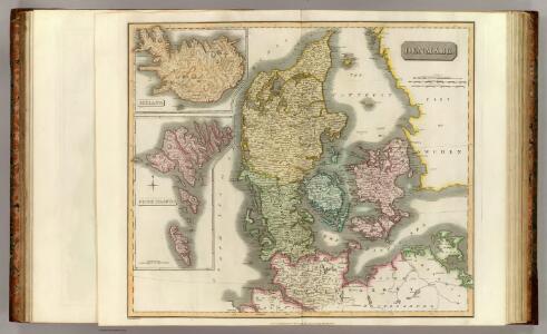
Denmark, Iceland, Feroe Islands.
1 : 960000 Thomson, John
Denmark.
1 : 1100000 Cary, John, ca. 1754-1835
Daenemark
Allgemeiner Atlas [Walch, Johannes] im Verlag bei Johannes Walch
Daenemark mit Schleswig, Holstein und Lauenburg auch Südl. Theil v. Schweden
Hand-Atlas über alle Theile der Erde nach dem neuesten Zustande und über das Weltgebäude Stieler, Adolf bei Justus Perthes
[Daenemark mit Schleswig, Holstein und Lauenburg auch Südl. Theil v. Schweden]
Hand-Atlas über alle Theile der Erde nach dem neuesten Zustande und über das Weltgebäude Stieler, Adolf bei Justus Perthes
[Daenemark mit Holstein und Lauenburg; auch Island und Fär-Öer]
Schul-Atlas über alle Theile der Erde nach dem neuesten Zustande, und über das Weltgebäude Stieler, Adolf bei Justus Perthes
Daenemark
E. von Sydow's Schul-Atlas in sechs und dreissig Karten Sydow, Emil von bei Justus Perthes
Daenemarck.
Dánsko Güssefeld, Franz L. Mollo, Tranquillo Tranquillo Mollo
Daenemarck
1 : 1260000 Bornholm (Dánsko) Mollo, Tranquillo Tranquillo Mollo
Daenemarck
1 : 1245000 Dánsko Tranquillo Mollo
Daenemarck.
Dánsko Güssefeld, Franz L. Mollo, Tranquillo Tranquillo Mollo
[Königreich Daenemark]
Neuester Schul-Atlas Walch, Johann im Verlag bei Joh. Walch
Daniae Regnum [Karte], in: Gerardi Mercatoris Atlas, sive, Cosmographicae meditationes de fabrica mundi et fabricati figura, S. 140.
1 Karte aus Atlas Mercator, Gerhard Montanus, Petrus
Daenemark mit Holstein und Lauenburg auch südlicher Theil von Schweden
1 : 3200000 Dánsko
Denmark, Sleswig, Holstein.
1 : 823680 Stanford, Edward
Denmark.
1 : 1250000 Teesdale, Henry
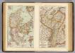
Denmark.
1 : 1837440 Tallis, J. & F.
Daniae Regnum [Karte], in: Atlas, sive, Cosmographicae meditationes de fabrica mundi et fabricati figura, S. 135.
1 Karte aus Atlas Mercator, Gerhard
Daniae Regnum [Karte], in: Gerardi Mercatoris et I. Hondii Newer Atlas, oder, Grosses Weltbuch, Bd. 1, S. 103.
1 Karte aus Atlas Mercator, Gerhard und Hondius, Jodocus Jansson, Jan
Denmark with Northwest portion of the German Empire
1 : 1332000 Johnston, Alexander Keith
Denmark with Northwest portion of the German Empire
1 : 1332000 Johnston, Alexander Keith
Regni Daniae Novißima et Accuratißima Tabula
1 : 1100000 Mollova mapová sbírka Visscher, Nicolaes Visscher, Nicolaus
Denmark with Northwest portion of the German Empire
1 : 1332000 Johnston, W. & A.K.
Denmark.
1 : 1800000 Mitchell, Samuel Augustus
Denmark.
1 : 1800000 Mitchell, Samuel Augustus
Denmark, Alsace-Lorraine, Palatinate.
1 : 1500000 Andree, Richard; Times (London, England)
Denmark.
1 : 1800000 Mitchell, Samuel Augustus
Dänemark mit Schleswig, Holstein
Dánsko