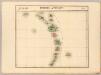
Maps of Lesser Antilles

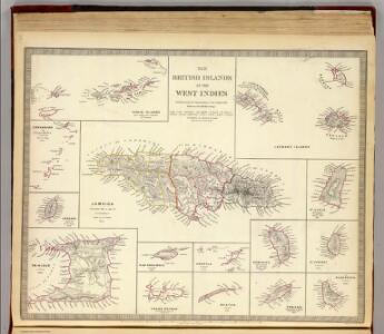
The British islands in the West Indies.
1 : 1090000 Society for the Diffusion of Useful Knowledge (Great Britain)
The Antilles.
1 : 5000000 Andree, Richard; Times (London, England)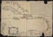
Carte des Isles Antilles dans l'Amérique septentrionale, avec la majeure partie des isles Lucayes faisant partie du théâtre de la guerre entre les anglais et les américains
1 : 3700000 Brion de La Tour, Louis, géographe 1756-1803 Paris : chés Esnauts et Rapilly
181. Haiti, Dominican Republic, Jamaica, Puerto Rico Island, Lesser Antilles, Trinidad and Tobago, Panama Canal (West Indies). The World Atlas.
1 : 3750000 USSR (Union of Soviet Socialist Republics).
A map of the English, French, Spanish, Dutch, & Danish Islands, in the West Indies, taken from an improved map of the geographer to the King of France, with the tract of the last West India Fleet, through the Windward Passage
1 : 4942000
Nova Isthmi Americani, qui et Panamiensis item Dariensis Tabula
Solo algunos mapas impresos por los hermanos Reinier y Josua Ottens llevan su impronta. Para armar sus atlas, los Ottens solían simplemente copiar o reimprimir mapas de otros cartógrafos holandeses y franceses. Este mapa del Istmo de Panamá evidencia, en cambio, adaptaciones y mejoras significativas de los Ottens a la Carte Particuliere De Isthmus ou Darien publicada por Pierre Mortier en 1700, poniendo particular énfasis en las islas, islotes, cayos, bajos, arenas, etc., del litoral centroamericano, así como en el relieve y la hidrografía del istmo y del continente. Ottens, R. (Reinier) (1698-1750); Ottens, J. (Josua) (1704-1765).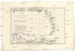
Les Petites Antilles ou les Isles du Vent avec celles de Sous le Vent
1 : 7320000 Malé Antily (souostroví) Bonne, Rigobert André
Carte des iles Antilles. Par J.B. Poirson . Nivose An XI, 1803
1 : 3100000 Herbin de Halle, Etienne de.
Carte des Antilles
1 : 2777775
Nieuwe Carybsche Pascaart: The Carybes Ilands [Karte], in: De Nieuwe Groote Vermeerderde Zee-Atlas ofte Water-Werelt, S. 65.
1 Karte aus Atlas Doncker, Hendrick
[Puerto Rico, Kleine Antillen, Trinidad]
1 Karte : Kupferdruck ; 44 x 55 cm Doncker bij Hendrick Doncker boeckverkooper en graadbooghmaeker inde Nieuwbrugh steegh in 't Stuurmans gereedtschap
CANIBALES | INSVLÆ.
[Amsterdam : Joan Blaeu]
Antilles, Charibbee Islands.
1 : 2700000 Faden, William, 1750?-1836
A CHART OF THE ANTILLES, or, CHARIBBE, or, CARIBS ISLANDS, WITH THE VIRGIN ISLES
This chart by cartographer L. S. de la Rochette (1731 ? 1802) was engraved by William Palmer and published by 'geographer to the King' William Faden in 1784. There is a compass rose at the centre of a network of rhumb lines (for sailing directions) and a smaller scale map of the region is inset at top right showing distances between the islands, sailing routes and a table recording latitude and longitude of each island. Down the right side of the map are represented the profiles of the headlands of the different islands- this is as they would appear to sailors from the sea. La Rochette. Cartographer.
Central America.
1 : 5068800 Colton, G.W.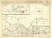
Carte particuliere de Isthmus, ou Darien, qui comprend le Golfe de Panama &c., Cartagene et les isles aux environs
1 : 1850000 Chez J. Cóvens et C. Mortier
Insula S. Iuan De Puerto Rico Caribes; Vel Canibalum Insulae. [Karte], in: Het vijfde Deel Des Grooten Atlas : Vervatende De Water-Weereld, S. 66.
1 Karte aus Atlas Jansson, Jan Jansson, Jan
Insula S.Iuan de Puerto Rico Caribes; Vel Canibalum Insulae. [Karte], in: Novus atlas absolutissimus, Bd. 9, S. 76.
1 Karte aus Atlas Janssonius Offizin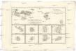
Cartes de supplément pour les isles Antilles
1 : 1330000 Antigua (Antigua a Barbuda) Bonne, Rigobert André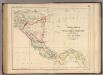
Central America.
1 : 3453120 Rogers, Henry Darwin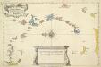
A New And Correct Map Of The Caribbean Islands From The Latest Observations
This map of the West Indies by Archebald Bontein was published in 1751. Bontein was the Chief Engineer in Jamaica and published a map of that island in 1763. A system of colour codes and letters, with the key in a panel at bottom centre, identifies the various European dominions in the region. Bontein, Archibald. Cartographer
Curacao. Amer. Sep. 74.
1 : 1641836 Vandermaelen, Philippe, 1795-1869
Grandes Antilles. Amer. Sep. 73.
1 : 1641836 Vandermaelen, Philippe, 1795-1869
South part of St. Domingo, or Hispaniola.
1 : 1560000 Jefferys, Thomas
Jamaica, Cape Gracias a Dios.
1 : 1560000 Jefferys, Thomas
De kusten van Caraques, Venezuela, Cartagena en St. Martha van Caap Caldera tot Caep Auga
Venezuela Gerard van Keulen
The Caribbee Islands, the Virgin Islands, and the Isle of Porto Rico.
1 : 1560000 Jefferys, Thomas
De kust van Carthagena, Tierra Firma, Costa Rica en de Honduras van Rio Grande de St. Martha tot Baija Honda int groot
Panama Gerard van Keulen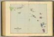
Leeward Islands.
1 : 887040 Stanford, Edward