Maps of Matruh

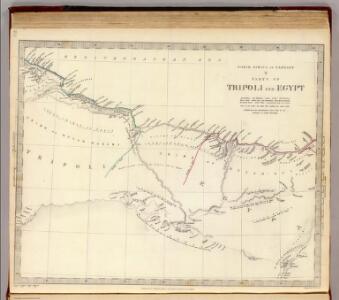
Tripoli, Egypt.
1 : 2000000 Society for the Diffusion of Useful Knowledge (Great Britain)
Egypt and Cyrenaica 1:250,000, Sidi Barrani-Matruh
Egypt and Cyrenaica 1:250,000 , Series GSGS 4386. Great Britain. Army. Middle East Command. [London] : War Office
Egypt, Western Desert 1:25 000 to 1:100 000, El Daba El Alamein
[Egypt, Western Desert 1:25 000 to 1:100 000]. Germany. Heer. Afrikakorps. [S.l.] : [Deutches Africa Korps]
Map of Baharia oasis
1 : 100000 Ball, David W. Survey of Egypt
27 Abu Mina.
1 : 100000 Jacotin, Pierre, 1765-1827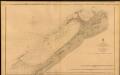
The Port of Alexandria, Egypt
The Port of Alexandria. Surveyed by Lieut. E. W. Brooker, etc. 1857. [Admiralty Chart] London
Alexandria ... Dikheila Extension. Scale 1 : 10,000
Alexandria ... Dikheila Extension. Scale 1 : 10,000. [El Giza] : Survey of Egypt.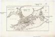
Geometrischer Grundiss der Stadt Alexandria
1 : 158000 Alexandrie (Egypt) Ausfeld, Johann Carl Gleditsch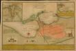
A plan of the cities of Alexandria
A plan of the cities of Alexandria vetus, and New Alexandria or Scanderia; with the old and new ports: also Lower Egypt and the Bay of Aboukir: with illustrations from the authorities of Norden, Tott, Volney & other eminent travellers / by, John Luffman, Geogr. Shows ancient and modern Alexandria. Text describes history of Alexandria and its rulers up to 1798. -- Inset of Bay of Aboukir includes brief description of the Battle of the Nile (July 1798). -- A second state published in The Naval Chronicle, 1807. Luffman, J. (John), 1756-1846 London: engraved & published Nov.r 5th, 1798, by John Luffman, no.2, Inner Sweetings Alley Royal Exchange. Price one shilling, plain, eighteen pence, coloured
[Sketch of Alexandria : reconstruction of historical places]
[S.l.] : [s.n.]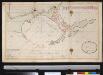
Afteekening van de haven van Alexandria agter in de Middellandsche Zee, aen de kust van Barbarija in Egypte
Egypt Laurent Brémond Gerard van Keulen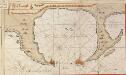
De haven van Alexandria
Egypt Gerard van Keulen
Egypt. Town Series, Alexandria (Sheet 20)
Egypt. Town Series ... Alexandria. Scale 1: 5,000. [El Giza] : Survey of Egypt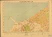
Egypt. Town Series, Alexandria (Sheet 14)
Egypt. Town Series ... Alexandria. Scale 1: 5,000. [El Giza] : Survey of Egypt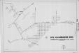
Cyrenaica, Lybia, Maddalena
Ente Colonizzazione Libia, comprensorio [district]. One of a collection of maps of districts in Libya; reproduced from Italian originals. [S.l.] : 512 Fd. Survey Co. R.E.
Piano dei due porti di Allesandria, e posezione della squadra Turco-Egizia in Agosto 1831
1 : 43000 Alexandrie (Egypt)
Stadtplan von Alexandria, 1:15,000
Stadtplan von Alexandria, 1:15,000. Germany. Luftwaffe Berlin : Luftwaffe.
38 El Hammam.
1 : 100000 Jacotin, Pierre, 1765-1827
Map of Mersa Matruh & Râs Allem Rum
1 : 25000 Survey department Egypt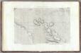
28 Fleuve Sans Eau.
1 : 100000 Jacotin, Pierre, 1765-1827
Africa 1:2.000.000, Cyrenaica
Cyrenaica, Libya
Feuille 47 (E VII), uit: Carte géologique internationale de l'Europe : la carte, votée au congrès géologique international de Bologne en 1881, est exécutée conformément aux décisions d'une commission internationale, avec le concours des gouvernements, sous le dir. de M.M. Beyrich et Hauchecorne
Annotatie: Blad 48 gamme des couleurs; blad 49: bladwijzer en titelblad Heinrich Ernst Beyrich 1815-1896; Wi. Hauchecorne Berlin : Reimer / (Berlin: Institut lithographique)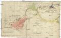
[Unter Ägypten]
Egypt Brose, Wilhelm
Feuille No. 7, uit: Carte de la Turquie d'Asie (moins l'Arabie) / dessiné et héliogravé au Service géographique de l'Armée
1 : 1000000 titelvariant: Turquie d'Asie; Annotatie: Titel boven de kaart: Turquie d'Asie; Bl. genummerd 1-4 en 7-10; Met lijst van de meest gebruikte woorden op de kaart vertaald uit het Turks, Arabisch en Perzisch; Annotatie geografische gegevens: Inzetkrt. op bl. 9: Plan de Jérusalem et de ses environs, Plan d'Alep, Plan de Damas et de ses faubourgs, Plan de Beyrout et de ses environs (alle 1:50.000) Service géographique de l'Armée [S.l. : Service géographique de l'Armée]
Libyan Desert [Route survey in the northern part of] (1894)
Route survey in the northern part of the Libyan Desert by Capt. H G Lyons RE, April 1894, IDWO 1042. Covers part of Egypt from Wadi Natrun to Bahariya Oasis. Great Britain. War Office. Intelligence Division. [London] : [War Office, Intelligence Division].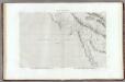
26 Lacs Natroun.
1 : 100000 Jacotin, Pierre, 1765-1827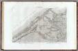
37 Alexandrie.
1 : 100000 Jacotin, Pierre, 1765-1827
Egypt and Cyrenaica 1:250,000, Salum-Torbruch
Egypt and Cyrenaica 1:250,000 , Series GSGS 4386. Great Britain. Army. Middle East Command. [London] : War Office
Egypt a průplav Suezský
1 : 3700000 Egypt