Maps of Norway

Sweden & Norway, northern, Russia.
1 : 4500000 Society for the Diffusion of Useful Knowledge (Great Britain)
Russia 1.
1 : 4435200 Letts, Son & Co.
Geologičeskaja karta Evropejskoj Rossii
1 : 2500000 Nordwest-Blatt Karpinskij, A.P. (Aleksandr Petrovič) Kartografičeskoe zavedenie A.Il'ina
Sweden, Norway.
1 : 8600000 Arrowsmith, Aaron; Lewis, Samuel
Sweden, Norway.
1 : 8600000 Arrowsmith, Aaron; Lewis, Samuel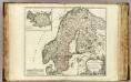
Suede, Norwege, l'Islande.
1 : 3800000 Robert de Vaugondy, Gilles, 1688-1766
N. European ports.
1 : 10000000 Philip, George
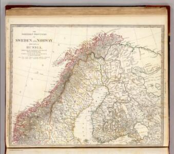
The northern provinces of Sweden and Norway with part I, of Russia
1 : 5000000 Finsko Walker, C. Baldwin & Cradock
Sueciae regnum cum vicinis regionibus
1 : 15900000 1 Karte : Kupferdruck ; 14 x 17 cm Weigel, Johann Christoph [Johann Christoph Weigel]
Das Koenigreich Schweden und Norwegen / verfertiget von Io. George Schreibern
1 : 12000000 1 Karte : Kupferdruck ; 15 x 20 cm, Bildgr. 16 x 24 cm Schreiber, Johann Georg [J. G. Schreiber]
Sweden, Denmark, Norway and Finland.
1 : 6400000 Carey, Mathew
[Skandinavien]
Skandinávie
SUECIAE Regnum cum vicinis Regionibus
Finsko
Karte des Baltischen Meeres
Baltské moře (oblast) Artaria
La Scandinavie où sont les royaumes de Suede, Danemark et Norwege
1 : 4000000 Jaillot, Alexis Hubert, 1632?-1712 chez Pierre Mortier

Homannův atlas světa
1 : 5000000
Sweden, Denmark, Norway.
1 : 8500000 Darton, William
Scandinavien bis zum Frieden von Friedrichshamm 1809.
1 : 6000000 Spruner von Merz, Karl
Nieuwe kaart van Noord-Europa / door A. de Moor
1 : 3250000 Moor, A. de (fl. 1920) [S.l. : Zijlstra]

Exactissima totius Scandinaviae tabula
Skandinávie Visscher, Nicolaes Jansz. Siebert, Selmar per Nicolaum Visscher
Sweden & Norway.
1 : 7600000 Tanner, Henry S.
Sweden & Norway.
1 : 7603200 Tanner, Henry S.

Svecia et Norvegia cum confinijs
1 Karte : Kupferdruck ; 53 x 46 cm Mercator; Hondius Henricus Hondius
Synopsis plagae septentrionalis, sive Sueciae Daniae et Norwegiae regn. accuratissime delineatum
Švédsko Seutter, Matthäus Lotter, Tobias Conrad studio Matth. Seütteri
Accuratissima regnorum Sueciae, Daniae et Norvegiae, tabula
1 : 4600000 Dánsko Danckerts, Justus per I. Danckers
Accuratissima regnorum Sueciae, Daniae, et Norvegiae, tabula
1 : 4000000 1 Karte : Kupferdruck ; 49 x 57 cm Danckerts, Justus [Danckerts]
Karte von dem Koenigreiche Schweden
1 : 3000000 Skandinávie Reilly, Franz Johann Josef von Müller, Franz Franz Ioh. Ios. von Reilly