Maps of North Atlantic Ocean
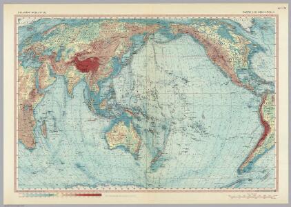
Pacific and Indian Ocean. Pergamon World Atlas.
1 : 50000000 Polish Army Topography Service
Bu harita, büyük Türk denizcisi Piri reis tarasindam 1513 tarihinde yapilmis olan ve Topkapi Müzesinde bulunan aslindan alinarak basilmistir
Atlantský oceán-oblast Devlet Basimevi
6-8. Linee di comunicazione, oceano Indiano, Pacifico.
1 : 30000000 Touring club italiano
Nord-Atlantischer Ocean.
1 : 28000000 Berghaus, Hermann
Carte de la partie de l'ocean vers l'equateur entre les cotes d'Afrique et d'Amerique où la situation des isles, bancs, et vigies
2 Karten auf einem Blatt : Kupferdruck ; Bildgrösse 48 x 64 cm Buache Philippe Buache
L'Ocean, Fernand de Noronha.
1 : 14800000 Compagnie des Indes
Africa.
1 : 21542400 Fullarton, A. & Co.
A new map or chart of the Western or Atlantic Ocean, with part of Europe Africa & America, showing the course of galleons, flota &c. to and from the West Indies
1 : 1800000 Bowen, Emanuel Cave, Edward
A new draught of the coast of GUINEA and BRASILE
from The sea-atlas : containing an hydrographical description of most of the sea-coasts of the known parts of the world.
A draught of the coast of AFRICA from the streights mouth to cape bona Esprance
from The sea-atlas : containing an hydrographical description of most of the sea-coasts of the known parts of the world.
Portugal.
From [Series of advertising cards issued by Arbuckle Bros. Coffee Company, each consisting of a map of a country of the world with related illustrations.]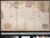
Niwe paskaard van de Spaanse Zee beginnende van Hitland of Eijsland en eijndigende aan Cabo Verde of de Zoute Eijlanden, lopende om de West tot aan de bancq van Terra Neuf, na de wassende graade paskaart gelegt
Atlantic Ocean Gerard van Keulen
Barbary and Bildulgerid ; A map of Zaara, Negroe-land, Guinea, &c. (Inset: The Isles of C, Verd)
from A system of geography, or, A new & accurate description of the earth in all its empires, kingdoms and states : illustrated with history and topography, and maps of every country : fairly engraven on copper, according to the latest discoveries and corrections / by Herman Moll.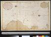
Wassende graade kaart van de Spaanse Zee van het Canaal tot voorbij de Vlaemse Eijlanden
Atlantic Ocean Gerard van Keulen
CARTE DE L'OCEAN MERIDIONAL
1 : 6700000 Atlantský oceán-oblast Bellin, Jacques-Nicolas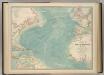
North Atlantic Ocean.
1 : 19000000 Johnston, W. & A.K.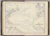
N. Atlantic Ocean.
1 : 19000000 Johnston, Alexander Keith, 1804-1871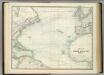
North Atlantic Ocean.
1 : 17500000 Johnston, Alexander Keith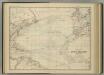
North Atlantic Ocean.
1 : 17500000 Johnston, Alexander Keith
Carte de l'ocean meridional
1 Karte : Kupferdruck ; 33 x 44 cm Bellin Arkstée et Merkus
Chart of the Atlantic Ocean.
1 : 43000000 Melish, John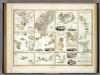
Specialia vom Vulkan Gurtel des Atlantischen Oceans.
Berghaus, Heinrich
Brasil, divided into its captainships.
from New & accurate description of the earth in all its empires, kingdoms and states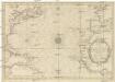
CARTE DE L'OCEAN OCCIDENTAL
1 : 6600000 Atlantský oceán-oblast Bellin, Jacques-Nicolas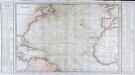
Carte générale de l'océan Atlantique ou Occidental
1 Karte : Kupferdruck ; 59 x 88 cm s.n.
Tableau des courants observés dans l'Océan Atlantique Septentrional, au moyen de bouteilles jetées à la mer. / dressé par P. Daussy, ingénieur hydrographe en chef de la Marine; gravé par Michel; écrit par J.M. Hacq.
from Atlantic Ocean P. Daussy; Michel; J.M. Hacq.,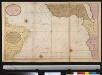
De zeekusten van Gunea van C. Verde tot Cabo de Bona Esperanco als mede de kusten van Brasil op wassende grade
Atlantic Ocean Gerard van Keulen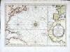
Carte de l'ocean occidental
1 Karte : Kupferdruck ; 31 x 44 cm Bellin Arkstée et Merkus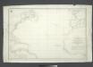
Carta general del Oceano Atlantico ú ocidental desde 52o de latitud norte hasta el Equador / construida de orden del Rey en el Deposito Hidrografico de Marina y presentada á S.M. por mano del Exmo. Señor D. Antonio Cornel, Secretario de Estado y del Despacho Universal de Guerra, Encargado del de Marina y de la Direccion General de la Real Armada.
from Atlantic Ocean D. Antonio Cornel,