Maps of South America

The World on Mercator's projection, western part.
1 : 40000000 Pinkerton, John, 1758-1826
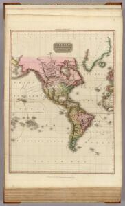
Western Hemisphere.
1 : 100000000 Lucas, Fielding Jr.
Volcanic action.
1 : 80000000 Johnston, Alexander Keith, 1804-1871
Neueste Karte von America
Grosser Hand-Atlas über alle Theile der Erde in 170 Karten Meyer, J. Verlag des Bibliographischen Instituts
W. Hemisphere.
1 : 100000000 Tanner, Henry S.
America.
1 : 67000000 Radefeld, Carl Christian Franz, 1788-1874
Amerika
Amerika Schlieben Gleditsch
America.
1 : 54000000 Melish, John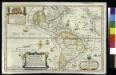
L'Amerique meridionale et septentrionale / dressée selon les dernieres relations et suivant les nouvelles decouvertes dont les points principaux sont placez sur les observations de Mrs. de l'Academie Royale des Sciences par N. de Fer ; C. Inselin, scr...
From Whole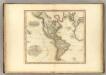
America.
1 : 43000000 Tanner, Henry S.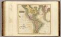
America.
1 : 43000000 Thomson, John
Nova Tabula Americae
Sandrart, Jakob von; Homann, Johann Baptist
America
1 : 40400000 Amerika Berra, Marco bei Marco Berra
Americae mappa generalis
Amerika Böhme, August Gottlob Hase, Johann Matthias in lucem proferentibus Homannianis Heredibus
AMERICAE Mappa generalis
Amerika Böhme, August Gottlob Hase, Johann Matthias in lucem proferentibus Homannianis Heredibus
Americae mappa generalis
Amerika Böhme, August Gottlob Hase, Johann Matthias in lucem proferentibus Homannianis Heredibus
Americae
Amerika Böhme, August Gottlob Homannianis Heredibus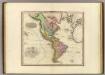
America.
Tanner, Henry S.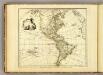
America.
1 : 50000000 Faden, William, 1750?-1836
America (blank)
1 : 50000000 Faden, William, 1750?-1836
Novissima et Accuratissima Totius Americae Descriptio [Karte], in: Novus atlas absolutissimus, Bd. 6, S. 194.
1 Karte aus Atlas Janssonius Offizin
Carte d'Amerique divisées en ses principales parties
1 Karte : Kupferdruck ; 47 x 57 cm L'Isle; Anville; Condet chez Cóvens & Mortier & Cóvens junior
Western Hemisphere.
1 : 95000000 Finley, Anthony
America 1841 mit Benutzung der neuesten Vermessungen
1 : 37600000 Amerika Arrowsmith, David K. Geographischen Anstalt des Bibliographischen Instituts
Recentissima novi orbis sive Americæ septentrionalis et meridionalis tabula
1 Karte : Kupferdruck ; 48 x 57 cm Wit; Ottens; Ottens ex officina R. et I. Ottens
Novissima et accuratissima septentrionalis ac meridionalis Americæ
1 Karte : Kupferdruck ; 42 x 53 cm Wit ex officina I. Cóvens et C. Mortier
Novissima et accuratissima septentrionalis ac meridionalis Americæ
1 Karte : Kupferdruck ; 48 x 56 cm Wit F. de Wit excudit
Novissima et accuratissima totius Americæ descriptio
1 Karte : Kupferdruck ; 48 x 56 cm Danckerts Justus Danckerts
Novissima et accuratissima totius Americæ descriptio
1 Karte : Kupferdruck ; 48 x 56 cm Wit F. de Wit excudit