Maps of Poland
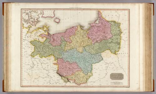
Prussian Dominions.
1 : 1440000 Pinkerton, John, 1758-1826
Prussian Dominions.
1 : 1450000 Thomson, John
Generale-Charte der Preussischen Monarchie in zwey Blättern
1 : 1030000 Prusko Streit, Friedrich Wilhelm Gilly Geograph. Institut
Charte des nordöstlichen Deutschlands nebst Preussen u. Polen
Preußen, Kongresspolen
Preussen, Polen.
1 : 3000000 Haller von Hallerstein, Friedrich; Reichard, C. G.
Charte von den Königreichen Preussen und Polen, dem Grosherzogthum Posen nebst dem Gebiete der freien Stadt Krakau. Nach dem am 3. May 1815 zu Wien zwischen Russland, Preussen und Oesterreich abgeschlossenen Tractate
Kongresspolen, Provinz Posen
[Nordöstl. Deutschland und Polen]
[Allgemeiner Atlas über alle Theile der Erde in 29 Blättern] Ziegler, Jakob Melchior Top. Anstalt v. J. Wurster u. Comp.
Prussia and Saxony.
1 : 3000000 Colton, G.W.
Germany, Prussia and Saxony.
1 : 2500000 Colton, G.W.
Prussia & Poland.
1 : 1584000 Arrowsmith, John
Prussia.
1 : 4118400 Lucas, Fielding Jr.
Die Preussischen Provinzen Preussen und Posen, und das Konigreiche Polen
1 : 1200000 Geographisches Institut (Weimar, Germany)
Prussia and Saxony.
1 : 3000000 Colton, G.W.
Prussia.
1 : 3400000 Finley, Anthony
Polen unter Boleslaw Chrobry und bis 1139
1 : 12000000 Polen Bolesław I., Polen, König
Germany, eastern border regions surface configuration
Relief shown by gradient tints. Includes most of western Poland. Includes location map. United States. Office of Strategic Services. Research and Analysis Branch. [Washington, D.C.] : R & A, OSS
Charte vom Königreiche Preussen dem Herzogthume Warschau und dem neuen Danziger Gebiethe
1 : 1510000 Gdaňsk-oblast (Polsko) Soltzmann, D. F. Geographischen Instituts
Carte de la monarchie prussienne, a l'orient du Weser
1 : 2300000 Prusko Mentelle, Edme Tardieu, Pierre François
Prussia.
1 : 3300000 Tanner, Henry S.
Prussian States.
1 : 3738240 Burr, David H., 1803-1875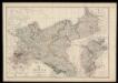
Prussia and Mecklenburg / drawn & engraved by J.W. Lowry
Lowry, Joseph Wilson Day & Son
[Nordöstliches Deutschland]
Schul-Atlas über alle Theile der Erde nach dem neuesten Zustande, und über das Weltgebäude Stieler, Adolf Justus Perthes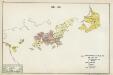
IV. 1640 - 1688
Brandenburg Expansion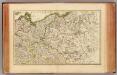
L'Alemagne 2.
1 : 1800000 Rizzi Zannoni, Giovanni Antonio Bartolomeo, 1736-1814
Prussia and Saxony.
1 : 3000000 Colton, G.W.
Charte vom Preussischen Staate oder Gebirgs- und Fluss- Charte des nördlichen Teutschlands
1 : 1700000 Neuchâtel (Švýcarsko) Streit, Friedrich Wilhelm Leutemann, H. J. C. Hinrichssche Buchhandlung
Polen und Preussen 1140 - 1240
1 : 6000000 Polen, Preußen (Ordensstaat)
Prussian States.
1 : 5200000 Arrowsmith, Aaron; Lewis, Samuel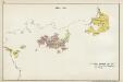
III. 1608 - 1619
Brandenburg Expansion