Maps of Indian Ocean

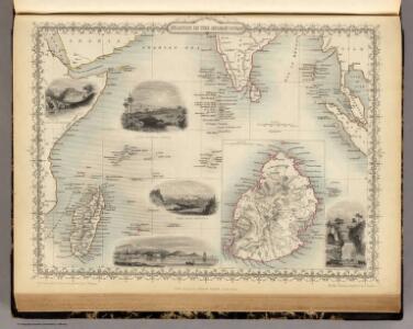
Islands In The Indian Ocean (with) inset map of Mauritius.
1 : 23760000 Tallis, J. & F.
Indian Ocean Islands.
Society for the Diffusion of Useful Knowledge (Great Britain)
[Azië], uit: Routekaart van Nederland naar Ned. Indië en terug
1 : 8000000 Annotatie: Samengest. op uitnoodiging der Stoomvaart Maatschappij Nederland Groustra, J. Amsterdam : Seyffardt
Indes II.
1 : 10000000 Bonne, Rigobert, 1727-1794
Arabian Sea.
1 : 10000000 Philip, George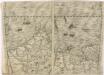
Bez titulu: Indie, Indický oceán

Carte d'une partie des Indes orientales, estats du Mogol les côtes de Malabar et de Coromandel &c
1 : 14000000 Himálaj-oblast par Cóvens et Mortier
Ost-Indien
[Allgemeiner Atlas über alle Theile der Erde in 29 Blättern] Ziegler, Jakob Melchior Top. Anstalt v. J. Wurster u. Comp.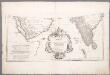
Prémière partie de la carte d'Asie : contenant la Turquie, l'Arabie, la Perse, l'Inde en deçu du Gange et de la Tartarie ce qui est limitrophe de la Perse et de l'Inde / par le Sr. d'Anville ; gravé par Guill. de-la-Haye
1 : 6650000 Annotatie: In: [Atlas du Sr. d'Anville], bl. 1 Anville, Jean Baptiste Bourguignon d'; Haye, Guill. de la A Paris : chez l'auteur
Ost-Indien oder Vorder-Indien
Schul-Atlas in 36 Karten Völter, Daniel Verlag der J.M. Dannheimer'schen Buchhandlung

Ost-Africa und Madagascar
Grosser Hand-Atlas über alle Theile der Erde in 170 Karten Meyer, J. Verlag des Bibliographischen Instituts
Ost-Africa, Madagascar.
1 : 12900000 Radefeld, Carl Christian Franz, 1788-1874
Charte von Zanguebar der Kafferküste und der Insel Madagascar : nach den neuesten und besten Hülfsmitteln
1 : 6800000 Reinecke, J. C. M. (Johann Christoph Matthias), 1770-1818 Im Verlag des Industrie Comptoirs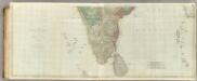
The East Indies, with the roads (southern section).
1 : 2600000 Jefferys, Thomas
Le royaume d'Adel
1 : 9600000 Jemen Bonne, Rigobert André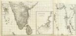
(Carte de l'Inde. Southern section).
1 : 3100000 Anville, Jean Baptiste Bourguignon d, 1697-1782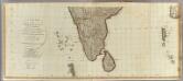
Hindoostan (south)
1 : 2500000 Robert Laurie & James Whittle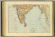
India South.
1 : 5448960 Stanford, Edward

A new mapp of the Island of ZELOAN
from The sea-atlas : containing an hydrographical description of most of the sea-coasts of the known parts of the world.
Topographical map of the Island of Madagascar
1 : 4580000 from the original design drawn on the spot by M. Roberts S.I. Neele sculpt. London : [s.n.]
CHARTE von OST-INDIEN diesseits des Ganges oder HINDOSTAN und DEKAN
1 : 10800000 Ganga-oblast (Indie a Bangladéš)
Charte von Ost-Indien diesseits des Ganges oder Hindostan und Dekan
1 : 11000000 Hindustán (Indie)
Carte Particuliere De L'Isle Dauphine ou Madagascar Et St. Laurens, Levée Par Ordre Expres des Roys De Portugal sous qui on en a Fait la Decouverte. [Karte], in: Atlas nouveau, contenant toutes les parties du monde [...], Bd. 2, S. 225.
1 Karte aus Atlas Sanson, Nicolas Jaillot, Alexis Hubert und Mortier, Pieter
Carte de l'Indostan servant à indiquer les possessions françaises en Asie
1 : 10000000 par A.M. Perrot gravé par les frères Malo Paris : Duprat-Duverger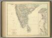
India (southern sheet).
1 : 4457000 Johnston, Alexander Keith
Carte de l'ile de Madagascar
1 : 4500000 réd. par B.F. Leguével de la Combe d'après ses reconnaissances, ses itinéraires, et les cartes du Depôt de la Marine dressée par A. H. Dufour ; la topographie par Felix Charpentier ; la lettre par Ch. Simon Paris : chez Desessart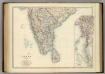
India (southern sheet).
1 : 4457000 Johnston, Alexander Keith