Maps of Gran Chaco

Carte du Grand Chaco et contrees voisines.
1 : 3750000 Martin de Moussy, V. (Victor), 1810-1869
Carte du Grand Chaco (Territoire Indien du Nord) et des Contrées voisines
1 : 2000000 Description géographique et statistique de la Confédération Argentine Martin de Moussy, Victor Librairie de Firmin Didot frères, fils et Cie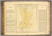
Paraguay.
1 : 2350000 Pierron, Jean Antoine
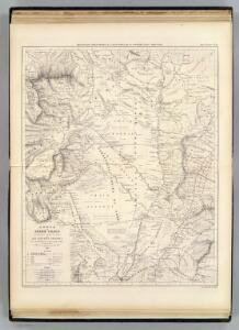
Carte, Province de Santiago del Estero, Grand Chaco.
1 : 1850000 Martin de Moussy, V. (Victor), 1810-1869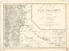
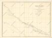
Map of the river Pilcomayo

Carte de la Province de Santiago del Estero et du Territoire Indien du Nord ou Grand Chaco
1 : 2000000 Description géographique et statistique de la Confédération Argentine Martin de Moussy, Victor Librairie de Firmin Didot frères, fils et Cie
Plano Nuevo de los Territorios del Chaco argentino
1 : 800000 Jorge Rohde Buenos Aires : G. Kraft
Partie, la Plata. Amer. Merid. 26.
1 : 1641836 Vandermaelen, Philippe, 1795-1869
Partie, la Plata. Amer. Merid. 30.
1 : 1641836 Vandermaelen, Philippe, 1795-1869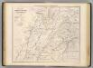
Carte, Prov. de Corrientes, Terr. des Missions, pays adjacents.
1 : 1850000 Martin de Moussy, V. (Victor), 1810-1869
Carte de la Province de Corrientes du Territoire des Missions et des Pays Adjacents
1 : 2000000 Description géographique et statistique de la Confédération Argentine Martin de Moussy, Victor Librairie de Firmin Didot frères, fils et Cie
Mapa de la Republica del Paraguay.
1 : 1490000 Paz Soldan, Mariano Felipe, 1821-1886
Gobernacion de Formosa.
1 : 1800000 Paz Soldan, Mariano Felipe, 1821-1886
Carte hist., Prov. des Missions, etabl. Jesuites, Parana et l'Uruguay, 1575- 1768.
1 : 1870000 Martin de Moussy, V. (Victor), 1810-1869
Carte Historique de la Province des Missions et des Établissements des Jésuites sur le Parana et l'Uruguay
1 : 2000000 Description géographique et statistique de la Confédération Argentine Martin de Moussy, Victor Librairie de Firmin Didot frères, fils et Cie
Provincia de Salta.
1 : 1800000 Paz Soldan, Mariano Felipe, 1821-1886
Gobernacion de Chaco.
1 : 1800000 Paz Soldan, Mariano Felipe, 1821-1886
Partie, la Plata. Amer. Merid. 31.
1 : 1641836 Vandermaelen, Philippe, 1795-1869
Provincia de Corrientes
1 : 1000000 Seelstrang, Arthur Eduard von 1838-1896 Buenos-Aires : J. Ruland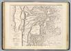
Carte, provinces de Salta et Jujuy, partie de la Bolivie.
1 : 1850000 Martin de Moussy, V. (Victor), 1810-1869
Carte des Provinces de Salta et de Jujuy et d'une partie de la Bolivie
1 : 2000000 Description géographique et statistique de la Confédération Argentine Martin de Moussy, Victor Librairie de Firmin Didot frères, fils et Cie
Carte des Provinces de Catamarca de Rucuman et des régions voisines
1 : 2000000 Description géographique et statistique de la Confédération Argentine Martin de Moussy, Victor Librairie de Firmin Didot frères, fils et Cie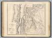
Catamarca et Tucuman.
1 : 1850000 Martin de Moussy, V. (Victor), 1810-1869
Partie du Perou. Amer. Merid. 25.
1 : 1641836 Vandermaelen, Philippe, 1795-1869
Provincia de La Rioja
1 : 1250000 Seelstrang, Arthur Eduard von 1838-1896 Buenos-Aires : J. Ruland
Provincia de Corrientes.
1 : 1800000 Paz Soldan, Mariano Felipe, 1821-1886
Provincia de Santiago del Estero.
1 : 1800000 Paz Soldan, Mariano Felipe, 1821-1886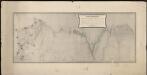
Plano topografico de la region norte argentina limitrofe con Bolivia
1 : 575000 (Argentine) Comision Argentina Demarcadora de Limites con Bolivia [Buenos Aires] :
Provincias de Jujuy y Tucuman.
1 : 1800000 Paz Soldan, Mariano Felipe, 1821-1886