Maps of Bucks County
Armees Americaine et Britannique en 1776 et 1777 dans le Maryland.
1 : 450000 Marshall, John
Various Regions and Cities in Pennsylvania.
Shell Oil Company
A mapp of ye improved part of Pensilvania in America, divided into countyes, townships, and lotts / surveyed by Tho. Holme.
from Whole
A New and accurate map of the present seat of war in North America, comprehending New Jersey, Philadelphia, Pensylvania, New-York, &c.
1 : 550000
Country from Rariton River in East Jersey to Elk Head in Maryland.
1 : 500000 Marshall, John
Delaware, Montgomery, Bucks counties.
1 : 300000 Gray, Ormando Willis; Walling, H. F.
Fac-simile of a portion of Holme's map of the Province of Pennsylvania : with names of original purchasers from William Penn 1681
Holme, Thomas, d. 1695 L. H. Everts & co.
Map Of The Vicinity Of Philadelphia
1 : 63360 Beers, S.N.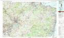
Trenton
1 : 100000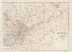
Map of the country around Philadelphia : with the good roads specially marked
1 : 63360 Smith, J. L Published by J. L. Smith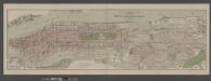
Boroughs of Manhattan and Bronx, showing the electric service of the New York Edison Co.
From Manhattan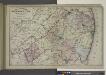
Topographical Map of Monmouth Co., New Jersey.
from Atlas of Monmouth co., New Jersey. From recent and actual surveys and records, under the superintendence of F.W. Beers.
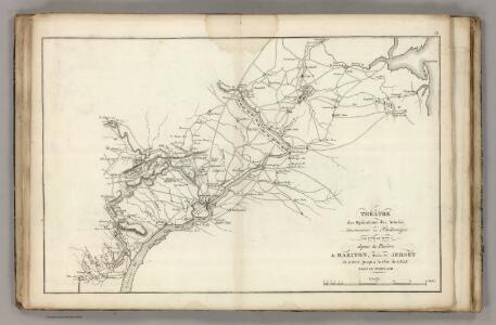
Plan of the operations of General Washington against the Kings troops in New Jersey : from the 26th of December, 1776, to the 3d January, 1777 / by William Faden.
from Cartographic materials from the Emmet Collection of Manuscripts Etc. Relating to American History.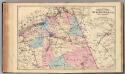
N. Burlington Co., N.J.
1 : 126720 Beers, F. W. (Frederick W.)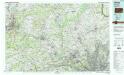
Reading
1 : 100000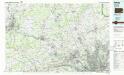
Reading
1 : 100000
Philadelphia and vicinity, Pennsylvania, New Jersey and Delaware / Henry Gannett, chief geographer ; H.M. Wilson, chief geographer in charge ; triangulation by U.S.C. and G.S. ... [et al.] ; topography by Geol. Survey of New Jersey ... [et al.]
1 : 62500 Annotatie geografische gegevens: Opname: 1894 Gannett, Henry; Wilson, H. M.; US Coast and Geodetic Survey; Geological Survey of New Jersey [Washington, D.C. : U.S. Geological Survey]
Philadelphia and vicinity : Pennsylvania and New Jersey
1 : 62500 Geological Survey (U.S.) U.S. Geological Survey
Norristown
1 : 125000
Trenton
1 : 125000
Trenton
1 : 125000
Trenton
1 : 125000
Navesink
1 : 125000
Navesink
1 : 125000
Navesink
1 : 125000
Philadelphia and vicinity, east, 1955 (and west, 1956) (Pennsylvania - New Jersey)
1 : 24000 Geological Survey (U.S.)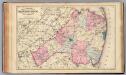
Monmouth Co., N.J.
1 : 126720 Beers, F. W. (Frederick W.)
8 Trenton.
1 : 63360 Vermeule, C. C. (Cornelius Clarkson), 1858-1950
12 Mt. Holly.
1 : 63360 Vermeule, C. C. (Cornelius Clarkson), 1858-1950