Maps of Poland
Carte historique de la Pologne.
1 : 5600000 Malte-Brun, Conrad, 1775-1826
Poland, Prussia.
1 : 2400000 Robert Laurie & James Whittle
Theilung 1772 ; Theilung 1793 ; Theilung 1795 ; Polen 1812, Theilung 1815
Polsko
Poland, Lithuania &c.
1 : 3050000 Bowen, Emanuel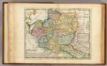
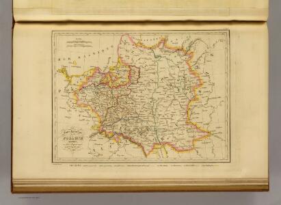
Poland.
1 : 6300000 Moll, Herman, d. 1732
Mapa rozmieszczenia bogactw kopalnych na ziemiach polskich
1 : 6300000 Polen Geologie Arct, Michał
Poloniae Regnum ut et Magni Ducat. Lithuaniae
1 : 8500000 Mollova mapová sbírka Dorn, Sebastian Raspe, Gabriel Nikolaus
Poland: Jews
1 : 3000000 Series of maps on various aspects of Poland. Distribution of Jewish minorities. War Office
Polen nach der Theilung im Jahre 1815, 1793, 1795 ; Die Theilung von Polen im Jahre 1772
Polsko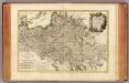
Pologne.
1 : 4000000 Rizzi Zannoni, Giovanni Antonio Bartolomeo, 1736-1814
Mapa rozmieszczenia gleb na ziemiach polskich
1 : 6300000 Polen Geologie Arct, Michał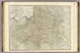
A new map of the Kingdom of Poland with its dismembered provinces.
1 : 2450000 Kitchin, Thomas
Poland: Lithuanians, Little Russians and Czechs
1 : 3000000 Series of maps on various aspects of Poland. Distribution of Lithuanians, Little Russians and Czechs, showing minorities. War Office
Mappa geographica ex novissimis observationibus repraesentans Regnum Poloniae et magnum ducatum Lithuaniae
1 : 2800000 Evropa východní Lotter, Tobias Conrad sumptibus Tobiae Conradi Lotter
Mappa geographica Regnum Poloniae ex novissimis observationibus repraesentans Regnum Poloniae et Magnum ducatum Lithuniae
1 : 2700000 Evropa východní Lotter, Tobias Conrad T. C. Lotter
Mappa geographica Regnum Poloniae ex novissimis observationibus repraesentans Regnum Poloniae et Magnum ducatum Lithuniae
1 : 2800000 Evropa východní Lotter, Tobias Conrad T. C. Lotter
Mappa geographica Regnum Poloniae ex novissimis observationibus repraesentans Regnum Poloniae et Magnum ducatum Lithuniae
1 : 2800000 Evropa východní Lotter, Tobias Conrad T. C. Lotter
Poland: Density
1 : 3000000 Series of maps on various aspects of Poland. Density. Number of inhabitants per square kilometre. War Office
Mappa Polski i krajow okolicznych
1 : 3810000 Evropa východní Sławinski, J.
Mappa geographica, ex novissimis observationibus repraesentans regnum Poloniae et magnum ducatum Lithuaniae
1 : 2700000 Bělorusko Lotter, Tobias Conrad
Mappa geographica, ex novissimis observationibus repraesentans regnum Poloniae et magnum ducatum Lithuaniae
1 : 2700000 Bělorusko Lotter, Tobias Conrad sumptibus Tobiae Conradi Lotter
Mappa geographica, ex novissimis observationibus repraesentans regnum Poloniae et magnum ducatum Lithuaniae
1 : 2700000 Bělorusko Lotter, Tobias Conrad sumptibus Tobiae Conradi Lotter
Mappa geographica, ex novissimis observationibus repraesentans regnum Poloniae et magnum ducatum Lithuaniae
1 : 2700000 Bělorusko Lotter, Tobias Conrad sumptibus Tobiae Conradi Lotter
Mappa geographica, ex novissimis observationibus repraesentans regnum Poloniae et magnum ducatum Lithuaniae
1 : 2700000 Bělorusko Lotter, Tobias Conrad sumptibus Tobiae Conradi Lotter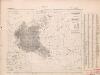
Poland: Poles
1 : 3000000 Series of maps on various aspects of Poland. Distribution of Poles showing minorities. War Office
Polonia regnum ut et magni ducat. Lithuaniae accuratiss. delin
1 : 6470000 Bělorusko Seutter, Matthäus Lotter, Tobias Conrad bey Tob. Conr. Lotter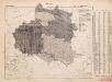
Poland: Language. No.2
1 : 3000000 Series of maps on various aspects of Poland. Distribution of languages according to various authorities. War Office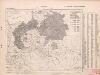
Poland: Germans and White Russians
1 : 3000000 Series of maps on various aspects of Poland. Poland. Germans and White Russians. Distribution of Germans and White Russians, showing minorities War Office
Bez titulu: soubor map pag. 245