Maps of South America
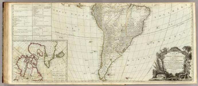
A new map of the whole continent of America (southern section)
1 : 12800000 Sayer, Robert
South America.
1 : 25344000 Carey, Mathew
Map Of South America.
1 : 25344000 Carey, Mathew
South America.
1 : 26000000 Carey, Mathew
Map Of South America.
1 : 25344000 Carey, Mathew
South America
Este mapa, sin fecha y sin autor conocido, probablemente sea de mediados del siglo XVIII. La representación de Islas Malvinas a partir del Estrecho de Falkland, como era común en la primera mitad del siglo XVIII, es un indicio en ese sentido. En enero de 1690 el inglés John Strong navegó entre las dos islas principales y llamó al paso "Falkland Channel" en honor a su mecenas el Vizconde de Falkland que como había financiado la expedición. La cartografía británica adoptaría en el siglo XVIII el nombre del canal, para designar a todo el grupo de islas, que reclamaría para Inglaterra, en contra de España. En 1740 hubo un enfrentamiento naval entre las fuerzas británicas y españolas por las islas, sin un claro vencedor. Las tensiones entre los dos imperios continuaría a lo largo del siglo XVIII.
South America and the Adjacent Islands.
1 : 3450000 Morse, Jedidiah
[Süd-Amerika]
Atlas der Geologie Zittel, K.v. ; Berghaus, Hermann Justus Perthes
L'Amerique meridionale divisée en ses principaux etats
1 : 1
South America, divided into its principall parts viz. the Firm-Land, Peru, Chili, Brasil, Paraguay the Magellanick Land and Islands, in which are distinguished the severall countries as they are at present possessed by the Spanish, English, Portugals, French, and Dutch, etc. / described by Sanson ; corr. and amended by William Berry
1 : 16000000 titelvariant: South America, divided into its principall parts, where are distinguished the severall states which belong to the Spanish, English, Portugals, and French; Annotatie: Titel in cartouche linksonder: South America, divided into its principall parts, where are distinguished the severall states which belong to the Spanish, English, Portugals, and French; Met opdracht aan Charles II Sanson, Nicolas; Berry, William London : William Berry
Ethnographische Karte von Süd-Amerika
Zweiter Band, enthaltend in vier Abtheilungen die Vertheilung der Organismen: 5. Pflanzen-Geographie, 6. Thier-Geographie, 7. Anthropographie, 8. Ethnographie Humboldt, Alexander von Verlag von Justus Perthes
South America.
1 : 48000000 Seaman, James V.
Sud-America.
1 : 27750000 Stulpnagel, F.v.
[Jižní Amerika]
1 : 50850000 Jižní Amerika
South America.
1 : 32000000 Smiley, Thomas T.
Süd-Amerika
[Allgemeiner Atlas über alle Theile der Erde in 29 Blättern] Ziegler, Jakob Melchior Top. Anstalt v. J. Wurster u. Comp.
Amerique du Sud.
1 : 16800000 Andriveau-Goujon, J.
South America divided into its principall parts where are distinguished the severall states which belong to the Spanish, English, Portugals, and French
1 : 16000000 Berry, William, fl. 1669-1708 Sold by William Berry at the sign of the Globe between Charing-Cross and White-Hall
L'America Meridionale nuovamente corretta
Mapa de Suramérica elaborado en uno de los más prestigiosos talleres cartográficos de Roma, con base en información del geógrafo francés Guillaume de Sanson. La gran calidad del grabado se puede apreciar en los detalles del cartucho decorativo y en la representación estilizada de las montañas de los Andes. En la región de Guyanas el mapa incluye el mítico Lago Parime, asociado al mito del Dorado y donde se ubicaría la fabulosa ciudad de Manoa, que los exploradores europeos buscaron infructuosamente en los siglos XVI, XVII y XVIII. Sanson, Guillaume (1600 - 1667) Vignola, Giacomo Cantelli da (1643 - 1695); Widman, Georgio de Rossi, Giovanni Giacomo (1627 - 1691)
[Süd-Amerika]
Hypsometrischer Atlas Ziegler, Jakob Melchior Topogr. Anstalt v. J. Wurster u. Comp.
Süd-America
Hand-Atlas über alle Theile der Erde und über das Weltgebäude Stieler, Adolf Justus Perthes
America Meridionalis
Waesbergen, yerno del famoso cartógrafo Johannes Janssonnius, heredó algunas planchas de grabado usadas por el taller cartográfico de la familia de los Hondius a principios del siglo XVII. Aunque estas planchas estaban bastante desactualizadas, permitían imprimir atlas de bajo costo que suplían un creciente mercado cartográfico. Esta reimpresión de un mapa, originalmente publicado en la década de 1620, representaba todavía la Tierra del Fuego como la parte norte de un vasto continente austral, pese a que desde la década de 1630 se supiera –gracias a los propios holandeses- que ésta solo era una pequeña isla al extremo sur del continente americano. Otros elementos interesantes del mapa son: la presencia de un gigante patagón en el cono sur del continente y el mítico Lago Parime en la región de las Guayanas. El mito de la existencia de gigantes y de la ciudad del Dorado en el Lago Parime, se mantuvo hasta el siglo XVIII. Waesberger, Jan Jansson van (fl. 1661 - 1681) Keere, Pieter van der (1571 – c.1646) Jan Jansson van Waesberger (fl. 1661 - 1681)
A new & exact map of the coast, countries and islands within ye limits of ye South Sea Company, from ye river Aranoca to Terra del Fuego, and from thence through ye South Sea, to ye north part of California &c. with a view of the general and coasting ...
1 : 32000000
Map of South America.
1 : 23000000 Winterbotham, W.
Süd Amerika
Geographischer Atlas über alle Theile der Erde Ziegler, Jakob Melchior Verlag von Dietrich Reimer
Carte physique de l'Amerique du Sud.
1 : 17000000 Martin de Moussy, V. (Victor), 1810-1869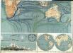
Physikalische Wandkarte der Erde in Merkartor's Projection

South America.
1 : 15840000 Fullarton, A. & Co.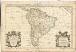
Amerique Meridionale divisée en ses principales parties ou sont distingués les vns des autres les estats suivant qu'ils appartiennent presentement aux François, Castillans, Portugais, Hollandois, &c
1 : 1600000 Jižní Amerika Sanson, Nicolas Jaillot, Alexis-Hubert chez H. Iaillot