Maps of Poland
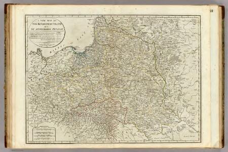
A new map of the Kingdom of Poland with its dismembered provinces.
1 : 2450000 Kitchin, Thomas
Theilung 1772 ; Theilung 1793 ; Theilung 1795 ; Polen 1812, Theilung 1815
Polsko
Polonia regnum ut et magni ducat. Lithuaniae accuratiss. delin
1 : 6470000 Bělorusko Seutter, Matthäus Lotter, Tobias Conrad bey Tob. Conr. Lotter
[Historisch-geographischer Atlas zu den allgemeinen Geschichtswerken von C. v. Rotteck, Pölitz u. Becker] : Polen von dem Aussterben der Jagellonen bis zur dritten Theilung; von 1572 bis 1795
von Julius Loewenberg Lithographie von B. Herder in Freiburg im Breisgau 1836 [Freiburg im Breisgau] : [Herder]
Die Teilungen Polens
1 : 10000000 Polen-Litauen Teilungen Polens
Pologne.
1 : 4000000 Rizzi Zannoni, Giovanni Antonio Bartolomeo, 1736-1814
Carte historique de la Pologne.
1 : 5600000 Malte-Brun, Conrad, 1775-1826
Zentren des Protestantismus im Polen des 16.-17. Jahrhunderts
Polen, Ukraine, Protestantismus Scheidig, Holger
Die Teilungen Polens
1 : 15000000 Polen Teilungen Polens
Mapa rozmieszczenia gleb na ziemiach polskich
1 : 6300000 Polen Geologie Arct, Michał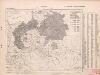
Poland: Germans and White Russians
1 : 3000000 Series of maps on various aspects of Poland. Poland. Germans and White Russians. Distribution of Germans and White Russians, showing minorities War Office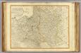
Poland, Prussia.
1 : 2400000 Robert Laurie & James Whittle
Poloniae Regnum ut et Magni Ducat. Lithuaniae
1 : 8500000 Mollova mapová sbírka Dorn, Sebastian Raspe, Gabriel Nikolaus
Mapa rozmieszczenia bogactw kopalnych na ziemiach polskich
1 : 6300000 Polen Geologie Arct, Michał
Poland: Language. No.1
1 : 3000000 Series of maps on various aspects of Poland. Languages in 1910-1913. War Office
Poland: Lithuanians, Little Russians and Czechs
1 : 3000000 Series of maps on various aspects of Poland. Distribution of Lithuanians, Little Russians and Czechs, showing minorities. War Office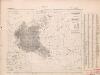
Poland: Poles
1 : 3000000 Series of maps on various aspects of Poland. Distribution of Poles showing minorities. War Office
Mappa geographica ex novissimis observationibus repraesentans Regnum Poloniae et magnum ducatum Lithuaniae
1 : 2800000 Evropa východní Lotter, Tobias Conrad sumptibus Tobiae Conradi Lotter
Mappa geographica Regnum Poloniae ex novissimis observationibus repraesentans Regnum Poloniae et Magnum ducatum Lithuniae
1 : 2700000 Evropa východní Lotter, Tobias Conrad T. C. Lotter
Mappa geographica Regnum Poloniae ex novissimis observationibus repraesentans Regnum Poloniae et Magnum ducatum Lithuniae
1 : 2800000 Evropa východní Lotter, Tobias Conrad T. C. Lotter
Mappa geographica Regnum Poloniae ex novissimis observationibus repraesentans Regnum Poloniae et Magnum ducatum Lithuniae
1 : 2800000 Evropa východní Lotter, Tobias Conrad T. C. Lotter
Poland: Poles (excluding Jews)
1 : 3000000 Series of maps on various aspects of Poland. Poles (excluding Jews). Kingdom of Poland (1897) an Galicia (1900). Distribution of Poles, showing minorities. War Office
[Geschichtlich-geographische Entwickelung des Zuwachses und der Abnahme des polnischen Reiches vom Jahre 992 bis zum Jahre 1831, dargestellt in fünf Karten] : V. Karte der Wiederherstellung Polens, 1807-1831
1 : 4800000 entw. u. gez. durch F.A. von Witzleben [Berlin] : [Reimer]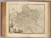
Poland, Lithuania &c.
1 : 3050000 Bowen, Emanuel
Mappa geographica regni Poloniae ex novissimis quot quot sunt mappis specialibus composita et ad LL. stereographica projectionis
1 : 2900000 Bělorusko Mayer, Tobias per Homannianos Heredes
[Geschichtlich-geographische Entwickelung des Zuwachses und der Abnahme des polnischen Reiches vom Jahre 992 bis zum Jahre 1831, dargestellt in fünf Karten] : IV. Karte der 3 Theilungen Polens von 1773-1795
1 : 4800000 entw. u. gez. durch F.A. von Witzleben [Berlin] : [Reimer]
Polen nach der Theilung im Jahre 1815, 1793, 1795 ; Die Theilung von Polen im Jahre 1772
Polsko
Poland: Jews
1 : 3000000 Series of maps on various aspects of Poland. Distribution of Jewish minorities. War Office
Volker und Reiche der Slaven zwischen Elbe und Don bis 1125.
1 : 5000000 Spruner von Merz, Karl