Maps of French Southern and Antarctic Lands
Indian Ocean.
1 : 26000000 Johnston, Alexander Keith, 1804-1871
Mare di India [Karte], in: Novus atlas absolutissimus, Bd. 9, S. 98.
1 Karte aus Atlas Janssonius Offizin
Mar di India [Karte], in: Het vijfde Deel Des Grooten Atlas : Vervatende De Water-Weereld, S. 82.
1 Karte aus Atlas Jansson, Jan Jansson, Jan
America.
1 : 42000000 Cary, John, ca. 1754-1835
America.
1 : 50000000 Bowen, Emanuel
Nova & accuratissima totius terrarum orbis tabula nautica, 3
1 Blatt : 51 x 48 cm R. & I. Ottens
America.
1 : 26000000 Kiepert, Heinrich, 1818-1899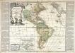
Amérique ou Nouveau Continent
1 Karte : Kupferdruck ; 45 x 52 cm, Gesamtgrösse 47 x 67 cm Nolin; Basset; Basset chez Basset rue St. Jacques
L'Amerique septentrionale [et] meridionale
1 Karte : Kupferdruck ; 45 x 56 cm Valck chez Gerard Valck sur le dam
Planisferio, posicion geografica de la Republica Argentina.
1 : 45300000 Paz Soldan, Mariano Felipe, 1821-1886
L'America secondo leultime osservazioni divisa né suoistati principali / Gio. Ma. Cassini Somo. inc.
from Whole Gio. Ma. Cassini Somo. inc.,
L'Ameriqve autrement le Novveav Monde et Indes Occidentales
1 Karte : Kupferdruck ; 36 x 37 cm Duval chez l'autheur au coin de la rüe de Harlay proche le palais
L'Ameriqve autrement le Novveav Monde et Indes Occidentales
1 Karte : Kupferdruck ; 37 x 37 cm Duval; L'Huilier chez l'autheur proche le fort l'Evesque
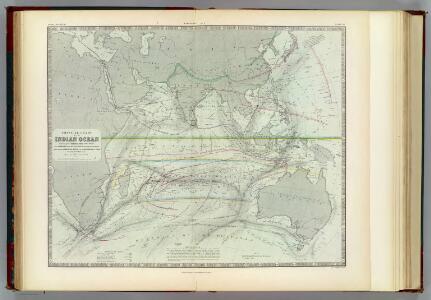
Physical Chart of the Indian Ocean
The physical atlas Johnston, Alexander Keith William Blackwood & Sons
Indian Ocean cables, wireless stations.
1 : 40000000 Philip, George
L'America divisa ne' suoi principali stati
1 Karte : Kupferdruck ; 30 x 40 cm Zatta; Zuliani presso Antonio Zatta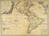
L'Amerique ou le Nouveau Continent
1 Karte : Kupferdruck ; 43 x 58 cm Nolin; Jenvilliers; Cochin chez l'auteur quay de l'Horloge du Palais a l'enseig.ne de la place des Victoires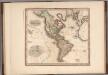
America.
1 : 44000000 Tanner, Henry S.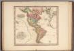
America.
1 : 44000000 Tanner, Henry S.
America.
1 : 44000000 Tanner, Henry S.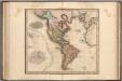
America.
1 : 44000000 Tanner, Henry S.
America
1 Karte : Kupferdruck ; 37 x 48 cm Mercator; Hondius; Hondius Jodocus Hondius excudit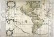
L'Amerique
1 Karte auf 4 Blatt : Kupferdruck ; 70 x 85 cm, Bildgrösse 70 x 105 cm Duval; Liébaux chez l'auteur en l'isle du palais sur le quay de l'Orloge proche le coin de la rüe de Harlay
The World on Mercator's projection, eastern part.
1 : 40000000 Pinkerton, John, 1758-1826
Physikalische Karte vom Indischen Meere
Erster Band, enthaltend in vier Abtheilungen die Erscheinungen der anorganischen Natur: 1. Meteorologie und Klimatographie. 2. Hydrologie und Hydrographie. 3. Geologie. 4. Tellurischer Magnetismus Humboldt, Alexander von Verlag von Justus Perthes
N & S America.
1 : 21000000 Jefferys, Thomas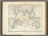
Physikalische Karte vom Indischen Meere.
1 : 44000000 Berghaus, Heinrich
Westliche Halbkugel
Amerika
Westliche Halbkugel
Amerika