Maps of Piedmont

Country drained by the Mississippi Eastern Section.
1 : 4752000 Long, Stephen H.
200-201. United States of America, North East Central. The World Atlas.
1 : 2500000 USSR (Union of Soviet Socialist Republics).
County map of the State of Illinois ; Plan of Chicago [inset].
from New general atlas.
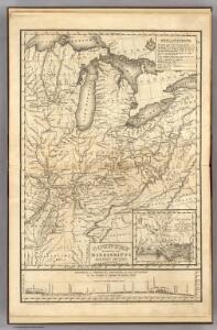
Die Staaten von Missouri, Illinois, Indiana, Ohio, Kentucky und Tennessee

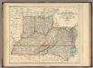
The Western Parts of Virginia, Pennsylvania, Maryland and North Carolina.
1 : 1140480 Hutchins, Thomas
Der Nördliche Theil der Vereinigten Staaten von Nord America
Hand-Atlas über alle Theile der Erde nach dem neuesten Zustande und über das Weltgebäude Stieler, Adolf bei Justus Perthes
Western Terr., Kentucky, Pennsylvania, etc.
1 : 3300000 Cary, John, ca. 1754-1835
Map of the Back Settlements.
1 : 6336000 Morse, Jedidiah
N.W. Territory.
1 : 8553600 Scott, Joseph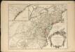
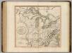
Partie de l'Amérique septentrionale, qui comprend le cours de l'Ohio, la Nlle. Angleterre, la Nlle York, le New Jersey, la Pensylvanie, le Maryland, la Virginie, la Caroline
1 : 3000000
Tourist through car line, Louisville & Nashville Railroad.
1 : 1900000 Louisville and Nashville Railroad Company
United States Of North America.
1 : 1550000 Arrowsmith, Aaron
A Map of the British American plantations, extending from Boston in New England to Georgia, including all the back settlements in the respective provinces, as far as the Mississipi
1 : 6350000
Western states, territories.
1 : 6400000 Grigg, John
N. W. Territory.
1 : 8236800 Carey, Mathew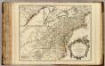
Cours de l'Ohio, Nlle. Angleterre, Nlle. York, Pensylvanie, Virginie, Caroline.
1 : 2900000 Robert de Vaugondy, Gilles, 1688-1766
Map showing the connections of the Illinois Central Railroad with the railway lines to the Gulf ports / engraved by H.H. Lloyd & Co.
1 : 2300000 H. H. Lloyd & Co, New York, N.Y [S.l. : s.n.]
A new and general map of the middle dominions belonging to the United States of America: viz. Virginia, Maryland, the Delaware-counties, Pennsylvania, New Jersey &c. with the addition of New York, & of the greatest part of New England &c as also of the bordering parts of the British possessions in Canada.
from Parts Published by Laurie & Whittle, No. 53 Fleet Street ...: London; Robert Laurie and James Whittle,
Lay's map of the United States / compiled from the latest and best authorities and actual surveys by Amos Lay, geographer and map publisher ; engraved by O.H. & D.S. Throop & Wm. Chapin.
From Whole
Bowles's new one-sheet map of the independent states of Virginia, Maryland, Delaware, Pensylvania, New Jersey, New York, Connecticut, Rhode Island, &c. : comprehending also the habitations & hunting countries of the confederate Indians.
from Bowles's universal atlas. ...
Middle British colonies in America
from Parts
Canada, Louisiane et Terres Angloises. (Northwest section)
1 : 2900000 Anville, Jean Baptiste Bourguignon d, 1697-1782
151. Centers farm, agricultural products, population, manufactures.
1 : 7000000 Gannett, Henry, 1846-1914; United States. Census Office
126. Centers of population, farms, agricultural products, manufactures 1790-1900.
1 : 7000000 Gannett, Henry, 1846-1914; United States. Census Office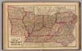
Delaware, Illinois, Indiana, Iowa ... North Carolina ... Tennessee, Virginia.
1 : 3000000 Lloyd, H.H.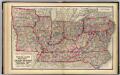
Delaware, Illinois, Indiana, Iowa ... North Carolina ... Tennessee, Virginia.
1 : 3000000 Walling, H. F.
County map of Michigan, and Wisconsin.
from Mitchell's new general atlas, containing maps of the various countries of the world, plans of cities, etc., embraced in fifty-three quarto maps., forming a series of eighty four maps and plans, together with valuable statistical tables.
Map New York Central Lines.
1 : 4200000 New York Central Railroad Company